〜From its origins as a castrum (military camp) to modern smart snow removal and the transformation into a walkable city〜
*This article is a specialized commentary based on knowledge as of December 2025 regarding the history of ancient Roman urban planning and modern urban engineering in Hokkaido.
"A city is not just a collection of buildings. It is the triumph of order (cosmos) over chaos, the very will of man written on earth."
When architect Le Corbusier once spoke about the importance of urban planning, the origins of the "order" he referenced were found in ancient Rome. The straight, wide streets that you use every day without even thinking about it, especially the orderly grid-like cityscapes seen in Sapporo and Toyako Town, are actually imbued with a powerful "philosophy" that has been passed down continuously since the Roman Empire over 2,000 years ago.
That is,"Cardo"と"Decumanus"These are the two absolute axes.
In ancient times, cities had a "sacred axis" running north-south and a "profane axis" running east-west. These were not simply roads for transportation. They were highly sophisticated systems that enabled military control, religious ceremonies, and served as economic arteries to keep the city thriving. Now, in modern Hokkaido, a rare "large metropolitan area in a cold, snowy region," this classic structure is undergoing a dramatic reevaluation in the new contexts of "disaster prevention," "snow removal efficiency," and "smart city."
This article takes a bird's-eye view of everything from Roman castrums (military camps) to the modern-day tourism urban development of Toyako Town in Hokkaido, and explains the historical significance of the axis that runs through the city and its potential for technological application in the future.
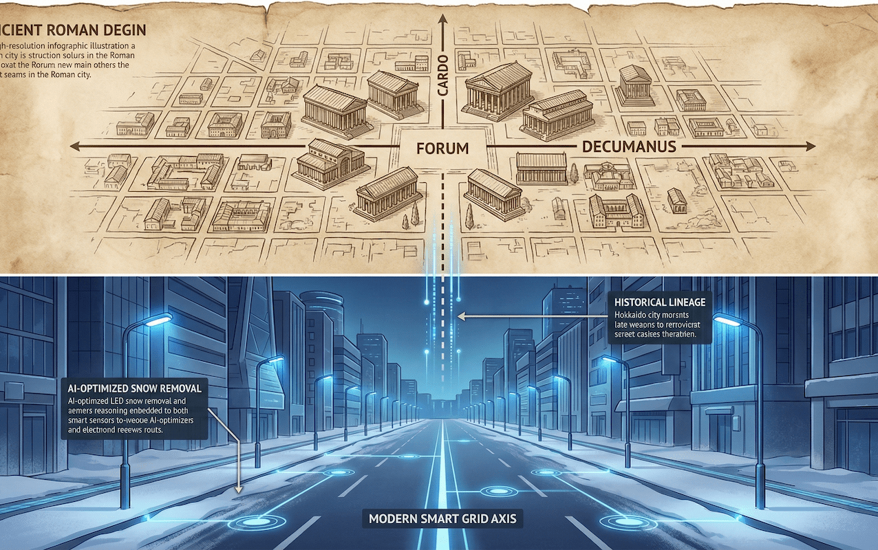
1. Ancient Roman City OS: The True Identity of the "Cardo" and "Decumanus"
From the strict perspective of urban planning or archaeology, the "cardo" and "decumanus" determine the very identity of a Roman city, and are like the city's operating system (OS). Places without these were not recognized as "urbs" by the Romans.
The "cosmic view" and "military logic" hidden in the etymology
Why were the Romans so obsessed with "perpendicular axes"? The answer becomes clearer when we unravel the Latin etymology.
North-South Axis / Sacred Line
Etymology:It means "hinge" or "axis." It is also the origin of the modern English word "Cardinal."
function:It was recognized as the direction that pointed to the axis of rotation of the celestial sphere (the North Pole). In urban planning, it was also a reference line for taking wind direction into account and creating healthy air flow.
East-West Axis / Secular Line
Etymology:It is named after the number "10 (Decem)" and is said to have been the dividing line between the 10th infantry (cohorus) and the 9th infantry in the Roman legion's camp.
function:Its axis aligned with the movement of the sun (east to west) and served as the main artery for the city's logistics, markets and commercial activities.
The intersection of these two main roads, the Cardo Maximus and the Decumanus Maximus, was called the Groma. It was the geometric center (zero point) of the city, and also the most important sanctuary of the city, where the Forum, a square where administrative buildings and temples were located, was located.
2. From Military Technology to Urban Civilization: How the Grid Dominated the World
This strict grid pattern had its origins in purely military requirements: the Castrum (military encampment): thousands of soldiers needed to set up fortified positions overnight in enemy territory, and the complex maze of streets would have been a hindrance to quickly locating which troops were where.
"Simplicity makes speed." For the Roman legions, perpendicular roads were a device that maximized the efficiency of logistics. As the Roman Empire expanded and colonies (colonia) were built throughout the country for veterans, the structure of these military camps was adapted for permanent urban planning.
- Barcelona (Barcino):The modern Gothic Quarter still bears the vivid traces of the Decumanus Maximus of that time.
- Colonnaded roads in the Middle East:In Palmyra in Syria and Jerash in Jordan, magnificent colonnades were built along the decumanus, creating "commercial corridors" that demonstrated the prestige of the cities.
- Paris (Lutetia):Rue Saint-Jacques on the left bank of the Seine corresponds to the former Cardo Maximus.
3. [Comparative Analysis] Roman Roads vs. Hokkaido's Odori
From here, we will compare and analyze the roads of ancient Rome and those of Japan's Hokkaido development period. Both use a grid, but their scale and design concepts show definite discontinuities and evolutions.
Comparison of main road widths (m)
*The graph below shows the width of representative main roads (main streets) in each era.
As is obvious at a glance, the width of the roads in Japan's planned cities (Heian-kyo and Sapporo) is on a "huge scale" that goes beyond practical transportation functions. While Roman roads were built with the minimum necessary width to specialize in "movement and logistics," Sapporo's main streets were tasked with the function of "firebreaks (open spaces to prevent the spread of fires)" from the very beginning of the development.
Detailed comparison table of design concepts
| Comparison items | [Ancient Roman City] (Original Grid) |
[Modern Hokkaido, Lake Toya] (Modern Grid) |
|---|---|---|
| Main purpose (Why) |
|
|
| The concept of the center (Where) |
Emphasis on intersections (groma) It has a centripetal structure with a square (forum) in the center. |
Emphasis on the axis (line) Rather than a central point, the road itself will function as an event space and park. |
| Weakness (Weakness) |
Difficulty adapting to the terrain. Since it travels in a straight line even on steep slopes, the load on movement can be high. |
A straight, windswept road. In winter, ground blizzards (whiteouts) and winds blowing through buildings are likely to occur. |
4. Reinterpretation and contemporary implementation of the "axis" in Toyako Town, Hokkaido
As a concrete case study, let's dissect the structure of Toyako Town in Hokkaido from a "Roman perspective." In this town, sandwiched between the overwhelming natural beauty of a volcano (Mount Usu) and a lake (Lake Toya), the two axes play extremely modern and compelling roles.
Caldo (north-south axis): An "evacuation axis" for coexisting with volcanoes
In Toyako Onsen town, the multiple approach roads that descend from the mountain side (Mount Usu) to the lakeside can be defined as modern-day "culdos." These serve as routes that lead tourists to hotels, and also as "escape routes" from volcanic disasters that occur every 20-30 years.
When Mt. Usu erupted in 2000, the well-organized road network contributed greatly to the rapid evacuation of residents. While the Roman castrum was a grid designed with enemy attacks in mind, Toyako's cardo was designed with the highest priority on evacuating from natural threats. Furthermore, the approach of preserving the roads themselves, which were uplifted and destroyed by the eruption, as "remains" and utilizing them as educational resources, such as the Konpira Crater Group Walking Path, resonates with the Roman attitude of passing on the city's memories to the future.
Decumanus (East-West Axis): A "Cultural Corridor" along the lakeside
In contrast, Lakeside Street, which stretches east to west along the lake, is a modern-day decumanus. It is not simply a national highway for through traffic. Toyako Town has redefined this axis as a linear plaza.
What is particularly noteworthy is the fusion of underground infrastructure with the above-ground landscape. In previous street construction projects, lifelines such as sewage pipes were buried underground, while the above-ground sections were developed into wide promenades. This successfully preserved the transparency of the lake (environmental protection) while creating an open-air museum with 58 sculptures (cultural promotion). This is a good example of how modern civil engineering techniques can be used to recreate the "joy of walking" and "urban dignity" of Roman colonnades.
Evolution into "Smart Decumanus".
Grid controls snow and data.
The Cardo and Decumanus are not simply 2,000-year-old archaeological remains, but physical manifestations of "humankind's fundamental will to create order in the chaos of nature and to secure a space for communication and logistics."
In the future, this classic grid structure will be combined with cutting-edge technology in cities across Hokkaido, including Toyako Town and Sapporo, and will undergo dramatic evolution.
- ✅ AI snow removal optimization:Straight grid roads are the best shape for deploying AI-powered self-driving snowplows.
- ✅ Walkable city:There will be a shift from a car-centered "road to pass through" to a "road as a place" where people stay, like the Roman Forum.
- ✅ Disaster Resilience:A simple and clear road network will continue to provide clear routes for transporting supplies and guiding evacuations in the event of a disaster.
We are now once again in the process of reshaping the axis of our city, from an inorganic space of asphalt to an organic space that protects life and fosters culture. The cardo and decumanus, reborn in the northern land after 2,000 years, will become the unshakable "backbone" of the sustainable society (sustainable city) of the future.
Related Links
- Ministry of Land, Infrastructure, Transport and Tourism: History and Role of Roads
- Hokkaido Regional Development Bureau: History of urban development in Sapporo
- UNESCO World Heritage Site: Historic Centre of Rome and the Papal States
Inquiries and requests
We help solve local issues.
Please feel free to contact us even if it is a small matter.


