〜How have Japanese people "designed" and "managed" space?〜
*This article is based on published data and academic knowledge as of December 2025.
*When viewing on a mobile device, you can scroll horizontally to view tables and graphs.
Have you ever looked down at the city below from an airplane window, or opened a map app on your smartphone and been captivated by a certain kind of "geometric beauty"?
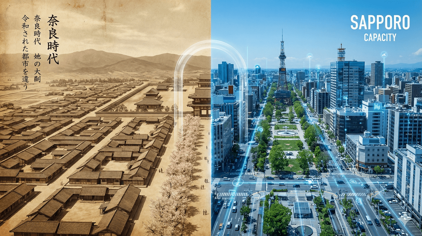
Kyoto's orderly grid system, Sapporo's beautifully laid out streets, and the vestiges of straight lines that remain in the Nara Basin - these are by no means the product of chance. They are remnants of gigantic national-level blueprints that ancient people drew on the earth more than 1,300 years ago in response to the grand question of "how should we govern this country?"
The name of the system"Jobo system"It is called.
For many people, the term "jobo system" is probably just an old term found in history textbooks. However, when we reconsider this system from the perspective of modern business, government, and urban development, we are faced with the fact that it was an astonishingly sophisticated "urban operating system (OS)." Visualization of authority, information management, and economic circulation—functions that are relevant today—were already implemented there.
This article explores how this grid system, which was passed down from Chang'an in ancient China to Heijo-kyo and Heian-kyo, is connected to modern-day Hokkaido and the cutting-edge landscape administration of Toyako Town. Deep knowledge of past archives is synonymous with gaining insights into future urban development in a society with a declining population.
1. Definition and Essence: What is the "Jobo System"?
Grid Design as a State Device
First, let's clarify the definition of the grid system. In a nutshell, the grid system is"An ancient East Asian city planning system in which straight roads running north-south, east-west, and across a vast area of land were laid out in a grid pattern, and the entire city was divided into orderly blocks for management."This refers to the following.
However, the essence of a city is not simply that the roads are straight. The French architect Le Corbusier once said that a city is a tool, and for ancient rulers, the grid system was the most powerful tool, the hardware, for running a nation.
Specifically, this system can be described as a huge master plan that integrates the following three functions:
-
① Grid pattern (framework for transportation and disaster prevention)
It serves as infrastructure for the rapid movement of troops and supplies, and also functions as a physical barrier to prevent the spread of fire. -
② Zoning (strict functional division)
A layout plan that clearly separates palaces (politics), government offices (administration), temples (religion), markets (economy), and residential areas (life) to optimize urban functions. -
③ Addressing (management by coordinates)
This database function uses coordinate axes of "jo (north-south)" and "bo (east-west)" to allow the state to instantly determine who lives where, thereby streamlining tax collection and conscription.
In other words, the Jobo system is not just about the shape of the town."Governance technologies for managing information and maintaining order"That was it.
2. Historical transition: From Chang'an to Heijo-kyo and then to Hokkaido
Acceptance of ancient global standards
So, where does this magnificent system originate? Its roots lie in ancient China. It is based on the idea of "masters running the country" as described in the Kaogongji of the Zhou Li (Records of the Zhou), which states that "the royal city should be a square with nine sides, with three gates on each side, and nine roads running north-south and east-west within the city."
From the 7th to the 8th century, Tang China was an overwhelmingly advanced country compared to Japan. The introduction of the grid system in Japan at that time was a major project that put the fate of the nation at stake, similar to importing the latest IT infrastructure to Silicon Valley today.
| Comparison items | [Ancient] Heijokyo (710) | [Present] Hokkaido (Sapporo/Lake Toya) |
|---|---|---|
| The origin of the design concept |
Emperor's authority and Ritsuryo rule To recreate the order of the universe (the theory of heaven and earth) on earth and demonstrate the legitimacy of governance both domestically and internationally. |
Efficiency and economic rationality Efficient sales of undeveloped land (Sapporo) and maximizing brand value as a tourist destination (Lake Toya). |
| Main Street |
Suzaku-oji: width approx. 74m More than twice the size of a modern highway. A huge "open space" for ceremony and prestige. |
Odori Park: Width approx. 105m While functioning as a firebreak, it has also been transformed into a place for citizens to relax and hold events. |
| Subject of spatial management |
Top-down by the state (Imperial Court) A one-sided control structure in which violators are severely punished. |
Collaboration between the government and citizens Regulations are implemented after reaching a consensus among residents based on landscape ordinances, etc. (collaboration). |
*Based on recent excavations conducted by the Nara National Research Institute for Cultural Properties, the width of Suzaku-oji in Heijo-kyo is estimated to be approximately 74m, including the gutters.
The data: 74 meters of waste creates authority
What is particularly noteworthy here is the extraordinary scale of Suzaku-oji, the main street of Heijo-kyo. It is approximately 74 meters wide. To get an idea of the scale of this road, let's compare it with modern roads.
[Illustration] Comparison of road widths (conceptual diagram)
*The percentages are relative ratios based on the maximum value (approximately 100m).
Even modern highways with three lanes in each direction are only about 30 meters wide. There is no way that a city with a population of around 100,000 at the time would have needed a width of 74 meters to meet the traffic demands.
So why was such width necessary? It was because this overwhelming "waste" was essential to visualizing the authority of the emperor. It was a long perspective created to look up at the palace towering in the distance. Urban planning has always been a device for sending out political messages.
3. Modern Jobo: The Challenge of Toyako Town, Hokkaido
Let's move the clock forward more than 1,000 years. During the Meiji period, the spirit of the grid system made a dramatic comeback in Hokkaido, Japan's northernmost prefecture.
Sapporo's urban planning was strongly influenced by American urban planning (grids from Washington, D.C., etc.), while also being strongly influenced by Kyoto's grid system. The way addresses are written, such as "Kita XX-jo Nishi XX-chome," and the division of the city into north and south with Odori Park as the axis, can be said to be a modern interpretation of the ancient grid system.
And now, this idea of "strictly managing space" has evolved into cutting-edge "landscape administration" in Toyako Town, Hokkaido.
Landscape as "capital" in tourist destinations
Toyako Town. This small town with a population of approximately 8,000 (as of 2024) is visited by over one million tourists annually. What is currently happening here is a "conscious spatial management" that is similar to the construction of ancient capital cities.
The town has enacted a "Landscape Ordinance" and designated particularly important areas as "Priority Landscape Areas." This can be thought of as a kind of sacred area designation, similar to the "Imperial Palace" of ancient times.
- Restrictions on tree and bamboo cutting:Within the priority zones, cutting down even a single tree may require notification.
- Color Control:The colors of the building's exterior walls and roof are guided to harmonize with the surrounding natural environment (earth tones, etc.).
- Skyline Preservation:By burying power lines underground and limiting building heights, the skyline and ridgelines are protected.
Why such strict regulations? If the ancient purpose was "political governance," what is the modern purpose?"Capital Maximization"is.
Beautiful scenery increases the length of time tourists stay, which in turn dramatically increases the average tourist spending. Landscapes are an economic resource that can be consumed.
[Analysis] Why is protecting the landscape profitable?
Let's analyze how landscape administration is linked to economic activity using tourism data from Toyako Town. There is a shocking "gap" here.
[Estimate] Comparison of tourism expenditures per unit in Toyako Town
(Source: Estimated based on Toyako Town tourist visitor numbers survey data for 2021)
The data speaks volumes. Overnight guests spend five times more money in a local area than day-trippers. And the essential element for attracting overnight guests is an "extraordinary environment (i.e., beautiful scenery) that makes people want to stay overnight."
This economic incentive is a strong driving force behind Toyako Town's efforts to protect its landscape, even if it means imposing a burden on the townspeople. A beautiful landscape is not just aesthetically pleasing; it is also the biggest factor supporting the local economy."Capital"So it can be said that this is the case.
4. Conclusion and the Future: Smart Shrinkage and the Age of "Choice"
However, this system also faces challenges. Both ancient capitals and modern cities face a common challenge: the struggle with maintenance costs.
In Heian-kyo, the swampy Ukyo (west side) fell into early decline and was virtually abandoned, a historical fact that the city shrank to accommodate its size.
Similarly, in modern Japanese regional cities where the population is declining, it is no longer possible to maintain all infrastructure and landscapes in a uniform manner."Smart Shrink"That's the idea.
It is predicted that future urban planning will become increasingly polarized as follows:
- Special occasions (high density management areas):Tourist hubs and residential areas are places where regulations are strengthened and stunning scenic beauty is maintained even at high cost, in order to earn foreign currency.
- Ke no Ba (return to nature area):Areas that are less managed and left to natural succession, or abandoned through intensification.
Just as ancient rulers once drew lines with rulers, we today find ourselves at a stage where we must coldly redraw the "city boundaries" based on data and consensus building.
Editor's Note: Landscapes are made up of "will" and "cost"
The ancient Greek philosopher Aristotle said, "People flock to cities to live, and stay in cities to live well."
From the magnificent Suzaku Avenue in Heijo-kyo to the detailed landscape regulations of modern Hokkaido, the "beautiful cityscapes" and "orderly roads" that we see every day are never born spontaneously. They are always the result of someone's strong and steadfast efforts.willAnd a hugecost(taxes, labor, restrictions on private rights), and meticulousplanIt is an "artificial order" that is barely maintained by
As we face the inevitable trend of population decline, we will be forced to make difficult choices about which landscapes to protect and which to let go. What the ancient grid system teaches us is that cities are not simply lumps of concrete, but are the very "projection of the will" of the people who live there.
What kind of "will" is the landscape of the city where you live based on? Why not take a moment to look at the city grid again and think about the blueprint behind it?
Related Links
- Ministry of Land, Infrastructure, Transport and Tourism: Promotion of Landscape Urban Development
- Nara National Research Institute for Cultural Properties: The Structure of Heijo-kyo and Suzaku-oji
- Toyako Town: Toyako Town Landscape Plan and Ordinance
Inquiries and requests
We help solve local issues.
Please feel free to contact us even if it is a small matter.


