〜Gaze control technology has evolved from a symbol of power to a platform for democracy〜
*This article is based on survey information as of January 2, 2026 and general urban planning theory.
Have you ever stopped to look around during your travels and come across a breathtakingly beautiful cityscape? Straight, tree-lined avenues, majestic temples and snow-capped mountains in the distance. This painting-like scenery is no coincidence.
In the disciplines of urban planning and landscape architecture, this visual effect is"Perspective"or"Vista"This is not just because it has a great view,"A deliberately controlled gaze"It refers to the very skeletal structure of a city that is constructed by
Why do beautiful cities need "dead ends"? And what specific financial impact do these landscapes have on modern business and real estate values?
This article delves deeply into the "design theory of perspective" hidden in urban spaces, from Baroque Paris to Washington DC, a symbol of American democracy, and modern-day urban development in Toyako Town, Hokkaido. We will unravel the enormous value brought about by invisible "axes" from both historical and data perspectives.
1. Definition and Structure of Perspective (Vista)
First, let's clarify the definition of the term. In urban planning, a "vista" refers to a visual device that consists of the following three elements:
[Three elements of a vista landscape]
- ① View Point:The position where the viewer stands.
- ② Axis:Straight roads, tree-lined streets, waterways, etc. that guide the eye act as a "frame."
- ③ Eye Stop:A symbolic object placed at the vanishing point (end of the line of sight), such as a landmark building, monument, or natural object such as a mountain.
By using this technique, cities are transformed from mere collections of buildings into spaces with dramatic narratives. For example, in Odori Park in Sapporo, the composition with the mountains and the former Hokkaido Development Commission headquarters visible at the far western end is not something that occurred naturally, but a typical example of a vista landscape calculated during the Meiji era city planning.
2. Historical Transition: From "King's Gaze" to "Symbol of Democracy"
If we trace the origins and evolution of the Vista landscape in detail, we can see that it has always contained political messages about who controls the city.
The Baroque City as a Stage for Absolute Monarchy
The vista technique was systematized and reached its peak during the European Baroque period from the 17th to 18th centuries, when it was put to maximum use in the reconstruction of Rome by Pope Sixtus V and the construction of the Palace of Versailles by King Louis XIV of France.
The endless straight roads radiating out from the king's castle visually symbolized the royal authority that extended to every corner of the country. The perspective that cuts straight through, ignoring the natural topography, was a metaphor for absolute power that even dominates nature.
Map: The axis of the Grand Canal can be seen stretching straight west (to the left) from the palace.
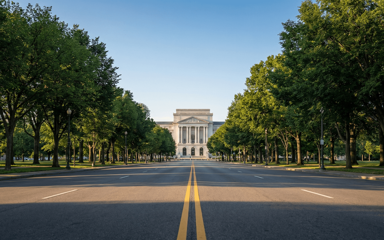
Changes brought about by the American "City Beautiful" movement
However, as time passed, in the late 19th and early 20th centuries in America, this method took on a new meaning in the "MacMillan Plan" (1901), a development plan for the capital, Washington, D.C.
Here, the original plan by the French architect Pierre-Charles L'Enfant was reevaluated, and a magnificent vista was completed, connecting the Capitol, the Washington Monument, and the Lincoln Memorial, centered around a huge green space known as the National Mall.
What is important here is that the focal point of the vista was not the king's palace but the "capital building" or the "presidential residence." The vista, which had previously been used to demonstrate the reach of power, was recast here as a stage setting expressing the "ideals of the nation" and the "prestige of democracy."
Map: A huge green axis stretches from the Capitol in the east to the Lincoln Memorial in the west.
3. Data: Comparison of "height restrictions" in major cities around the world
To maintain beautiful vista views, physical regulations, especially building height restrictions, are essential. Let's compare the regulations in major cities to see how they ensure sky space.
| City name | Regulatory basis law | Regulatory structure and characteristics |
|---|---|---|
| Washington, D.C. (America) |
1910 Building Height Restrictions Act (Height of Buildings Act) |
[Road width linked type] In commercial areas, the limit is the width of the road plus 20 feet (approximately 6 meters). The maximum height will be limited to about 40m, ensuring a clear view of the sky above the Capitol building. |
| Paris (France) |
Regional Urban Planning (PLU) *Revised in 2023 |
[Reinstatement of absolute height restrictions] The limit was relaxed in 2010, but after a debate over the landscape, it will be tightened again to 37 meters (approximately 12 stories) in 2023, returning to a policy of protecting the historic streetscape. |
| Kunitachi City (Tokyo, Japan) |
District planning/Landscape ordinance |
[Vista conservation type] On Daigaku-dori Avenue, an absolute height limit of 20m has been set to protect the tree-lined streets and the view of Hitotsubashi University's auditorium (this was tightened following a lawsuit against the condominium complex). |
As can be seen from the comparison above, the global trend is swinging back from "unlimited high-rise construction" to "appropriate height control." The case of Paris in particular can be seen as a symbolic decision to choose aesthetic benefits over development benefits, as it tightened regulations after they had once been relaxed.
4. Economic value of landscape: creating a premium
Can the "price of the sky" be calculated?
People often argue that "landscapes don't make money" or "it's a matter of personal taste," but modern urban economics is proving this to be false. Visual order in cities generates clear economic value (a premium).
Below is a visualization of survey data on the impact of landscape factors on real estate values and consumer behavior.
[Figure] Estimated economic impact of landscapes and views
*Source: Estimates based on domestic and international real estate hedonic price method research and commercial land surveys
The influence of a waterfront view is particularly significant. One study found that properties with a view of a lake or the ocean can have a value increase of up to approximately 89.91 TP3T compared to properties without such a view. Furthermore, in walkable commercial districts with tree-lined streets and vistas, consumers tend to spend 91 to 121 TP3T more, and are more willing to visit the area even from afar.
British Prime Minister Winston Churchill once said,"We shape the architecture, and then the architecture shapes us.""A chaotic skyline can put a strain on people's psychology, but a well-calculated vista and open sky can foster civic pride among the people who live there, ultimately boosting the brand value and property tax revenue of the entire area," he said.
5. Case Study: The Challenge of Toyako Town, Hokkaido
One area in Japan is trying to apply the Vista theory to strategic tourism development in a modern way: Toyako Town in Hokkaido, known worldwide as the Toyako-Usuzan Geopark.
Map: The relative positions of Lake Toya (bottom) and Mount Yotei (top pin position) located to the north.
Visualizing the "Tales of the Sea and the Earth"
Toyako Town is blessed with overwhelming natural resources that are world-class, including the caldera lake Lake Toya, the active volcano Mount Usu, and Mount Yotei (Ezo Fuji). However, simply having these individual resources scattered around will not maximize the overall appeal of the area as a tourist destination. This is where the idea of a vista, which visually connects these resources, becomes important.
The town's urban master plan and landscape plan include the following strategic regulatory guidance:
By preserving a vista that places Mt. Yotei and Nakajima on the extension of the road, a space will be created where you can feel the "power of the earth" no matter where you are in the city. This is a spectacular urban design unique to a geopark, with an active volcano as a landmark, replacing the obelisks of Rome.
By strictly limiting the height of buildings on the front row of the lakefront (including encouraging low-rise buildings in the Toyako Shore Priority Zone), we will prevent the creation of a huge "wall" along the lakefront. This will allow hotels and residences in the hinterland to see the lake, creating a "win-win structure" that will raise real estate values throughout the town.
European mountain resorts, such as Zermatt in Switzerland, attract wealthy people from all over the world because strict regulations guarantee the experience of seeing the Matterhorn from every hotel window. Toyako Town's approach suggests that Japanese local governments have entered a phase where they are competing on the quality of their landscape rather than the amount of development (floor area ratio).
6. Future Outlook: Technology and Consensus Building
Finally, let's touch on the technological advances that will come with landscape urban development. In the past, landscape debates tended to become pointless arguments, with people saying things like, "You can't really know until it's built," or "It's all subjective." However, technology will remove these barriers in the future.
Digital twin and VR advance experience
"If we build a new hotel here, how will the view of Mt. Yotei from Main Street change?"
A future is fast approaching where all residents will be able to experience this simulation during the planning stage using VR (virtual reality) and digital twin technology. By checking the position of the sun throughout the seasons and changes in viewpoint within an accurate 3D model, the vista landscape will evolve from being the property of a select few experts or the government to being a "commons" (shared property) shared and managed by all residents.
Conclusion: Leaving a "frame" for the future
The technique of "perspective," which was once born out of the desire of those in power to dominate, has now transformed into a means for everyone to equally enjoy the stories of local nature and history.
When it comes to urban development and real estate selection, what we need to consider is not just short-term figures like "how much floor space can we get under current legal regulations?""What do we want to see at the end of that road? What kind of perspective do we want to leave for the next generation?"The question is:
The straight road leading to the iconic ice stop may be a silent compass pointing out the future direction we should take in today's uncertain and confusing society.
Frequently Asked Questions (FAQ)
- Q. What is a Vista View?
- A. It is a visual device in urban planning that places an iconic building or natural landmark at the end (eye stop) of a straight road or tree-lined avenue, focusing the viewer's gaze on one point.
- Q. Are there any representative examples in Japan?
- A. Some famous examples include Odori Park in Sapporo (viewing the mountain range to the west), Daigaku-dori Street in Kunitachi, Tokyo (viewing the Kanematsu Auditorium at Hitotsubashi University), and Nihon-dori Street in Yokohama, Kanagawa Prefecture.
- Q. What is the impact on property values?
- A. Good views (especially of waterfront areas and historical buildings) are a factor in increasing real estate value. On the other hand, height restrictions restricting floor area ratios reduce the scale of development, so striking a balance is a topic of discussion.
Related Links
- Ministry of Land, Infrastructure, Transport and Tourism: Promotion of Landscape Urban Development
- National Capital Planning Commission (Washington DC)
- Toyako Town: Landscape Administration
Inquiries and requests
We help solve local issues.
Please feel free to contact us even if it is a small matter.


