〜The visual tricks of Baroque urban planning and the modern economic effects of pedestrianization〜
*This article is a full-length report based on the latest research and historical documents as of January 2026.
"The city is itself a vast theatre," as Lewis Mumford once said. Great urban spaces are "staged" to captivate visitors and draw them into the story.
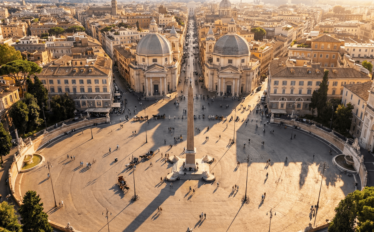
The ultimate example of this is a sacred place that urban planners and architects around the world refer to: Piazza del Popolo, the northern gateway to Rome, Italy.
The vast oval square, the central obelisk reaching for the sky, and the three streets fanning out from it, known as "Il Tridente," are more than just a road network for managing traffic. They reveal the political ambitions of centuries of popes, the sophisticated geometric tricks of Baroque architects, and meticulous calculations to stimulate the city's economic activity.
This article will thoroughly analyze the unknown "visual magic" that created this historical space, and will also attempt a bold simulation to see how this knowledge can be applied to urban development in Toyako Town, Hokkaido, a faraway northern region of Japan.
1. Deep History: From the Haunted Tomb to the "Holy Gateway"
Today, Piazza del Popolo is a popular place of relaxation with its elegant cobblestone streets and fountains, but tracing its origins reveals a surprising, dark side to its history.
The ghost of Emperor Nero and the construction of the church
In ancient Rome, this place was located at the northern end of the Campus Martius (Field of Mars), and was the boundary where the Via Flaminia entered the Roman walls. However, for medieval Roman citizens, this place was a "forbidden place" that should never be approached.
According to legend, the site of Santa Maria del Popolo today was the tomb of the notorious tyrant, the fifth emperor Nero, and was feared to be haunted by evil spirits, swarming with crows, and a constant stream of bad luck.
A turning point came in 1099, when Pope Paschal II, in order to dispel this evil legend and purify the land, collected donations from the citizens (popolo) to build a church. This is one of the reasons why the square got its name, "Popolo (Citizens' Square)" (there is also a theory that it comes from Poplar Forest). In other words, the square did not start out as part of an urban project, but rather began to carve out its history from religious motives as a kind of "exorcism."
The journey of the "obelisk" that defines the center of gravity of the city
The square began to take on its current structure from the late Renaissance to the Baroque period. The most notable change was the relocation of the Flaminio Obelisk in 1589.
Pope Sixtus V, at the time, carried out the grand "Great Remodeling Plan for Rome" to reorganize the dilapidated urban structure of Rome, connecting the major basilicas with straight roads and placing obelisks at the intersections of these roads as landmarks. This obelisk is not just a decoration.
| item | Detailed Data |
|---|---|
| Origin/production period | Around 1300 BC (Egyptian 19th Dynasty, Seti I/Ramses II) |
| Deportation to Rome | 10 BC (as spoils of war by Emperor Augustus) |
| Installation in the plaza | 1589 (architect Domenico Fontana) |
| Height and weight | Main body approximately 24m (approximately 36.5m including base) / Estimated weight 235 tons |
By placing this obelisk as the central point, a strong "centripetal force" was created in what had previously been a vague open space. This was the starting point for the later "Tridente" (three-way intersection) concept.
2. Spatial Magic: "Gaze Control" by Tridente and the Twin Churches
What makes Piazza del Popolo a landmark in the history of urban planning is the existence of the three streets radiating out from the south side of the square, known as "Il Tridente" (the trident).
Functions of the "Tridente" radial road system
If you turn your back to the obelisk and face south, you will see the following three roads unfolding in a fan shape. This structure had a great influence on the urban planning of the Palace of Versailles and Washington, D.C.
-
1. Via del Corso – Central
A direct descendant of the ancient Via Flaminia, it is the "spine of the city" that leads directly to Piazza Venezia in the heart of Rome. -
2. Via di Ripetta – right wing (west)
This road led to the port of Ripetta on the Tiber River and served as a route for logistics and commerce. -
3. Via del Babuino – left wing (east)
This road leads to the Spanish Steps and served to guide pilgrims towards the Basilica of Santa Maria Maggiore.
▲ Google Map: Three streets can be seen extending south from the square (north).
[Deep Dive] The "geometric lie" hidden in the Twin Churches
At the starting point of the Tridente, sandwiched between three roads, two wedge-shaped sites stand two churches that at first glance look identical: Santa Maria in Montesanto (left) and Santa Maria dei Miracoli (right).
However, did you know that this work also contains the sophisticated trompe l'oeil technique unique to Baroque architecture?
In fact, the two sites are asymmetrical, with the site on the left (Monte Santo side) being narrower. If they were built to the same blueprint, the church on the left would look cramped, and the symmetry of the square would be destroyed.
So the architect Carlo Rainaldi (who later collaborated with Bernini and Carlo Fontana) came up with the following solution:
| Comparison items | Left: Montesanto Church (Santa Maria in Montesanto) |
Right: Church of Miracoli (Santa Maria dei Miracoli) |
|---|---|---|
| Site conditions | Narrow width | There is ample width |
| Dome shape | oval(Duodecagonal plan) | Perfect circle(Octagonal plan) |
| visual effects |
When viewed from near the obelisk, due to the effect of perspective "Twins of the exact same size and shape"It has been corrected to look like this. |
|
In this way, the essence of Baroque urban planning lies in overcoming physical constraints through geometric ingenuity and artificially creating the "ideal urban landscape."
3. Modern Values: Economic Revitalization through Pedestrianization
Although Piazza del Popolo is a historical heritage site, it was used as a roundabout for automobiles until the 1990s, and was a place filled with exhaust fumes and noise. However, after it was "fully pedestrianized" in 1998, its value has dramatically changed.
Correlation between walkability and economic indicators
Contrary to shop owners' concerns that "removing cars will drive away customers," pedestrianization has had a huge economic impact on the surrounding areas. The graph below shows the trend in the impact of pedestrianization projects on commercial sales in major cities around the world.
[Illustration] Increase in retail sales after pedestrianization (major examples)
*Retail sales increased by 221 TP3T, and vacancy rates fell significantly
*Example of pedestrianized zone in the Strøget district
*Laneway Regeneration Project
Source: Created based on data from NYC DOT, Gehl Architects, etc.
In Piazza del Popolo, pedestrians can now move freely around the area, and the terrace seats of cafes facing the square, such as Rosati and Canova, are always full, dramatically improving their brand value. Ensuring "comfort" and "connectivity" in urban spaces is no longer simply about beautifying the landscape, but can be said to be an economic strategy with the highest ROI (return on investment).
4. Application to Toyako Town, Hokkaido: Natural Obelisks and Winter Strategies
Now let's shift our perspective to Toyako Town in Hokkaido, Japan. At first glance, the stone-built city of ancient Rome and Hokkaido's naturally rich hot spring resorts seem to have nothing in common. However, when it comes to the essence of "controlling the gaze and creating the framework of a city," Roman wisdom offers extremely useful insights.
Strategy 1: Define "natural obelisks"
Just as the Roman Trident converges towards an artificial obelisk, in Toyako Town, the natural landscape itself, with its overwhelming scale, should be redefined as the "eye stop (end point of the line of sight) of the city axis."
Flaminio Obelisk
By placing artificial vertical elements, we visualized a sense of direction and authority within the maze-like urban area.
Mount Yotei, Nakajima, and Showa Shinzan
We will identify points (vista points) from existing roads (such as Route 2 and Lakeside Street) where these mountains and lakes can be seen directly ahead, and then create a "subtraction design" by removing utility poles and signs from that axis.
▲ Google Map: The relative locations of Lake Toya and its surrounding areas (Mount Yotei, Nakajima, and Showa Shinzan).
Strategy 2: Reinventing the Square as a "Winter City"
The biggest challenges facing Hokkaido are snowfall and harsh winters, which Rome lacks. Vast open spaces like Piazza del Popolo can become barren wastelands in winter, with cold winds blowing through.
However, paradoxically, by viewing snow as a building material rather than an obstacle, a new form of plaza can emerge.
- Variable Square:In the summer, it functions as an open square like that of Rome, and in the winter, the space is segmented by snow sculptures and igloos, reconstructing it as a collection of "small places."
- Modern Gangi:Like a Roman portico, a series of semi-outdoor walkways will be installed in front of the building, creating a network of "protected pedestrian spaces" where people can enjoy the streetscape while avoiding snow and wind.
As Sapporo's "Chi-Ka-Ho" (underground pedestrian space) has proven, providing a comfortable walking environment in winter is a vital part of maintaining economic activity. Toyako Town needs to create plazas and axes that can function throughout the year, not by going underground, but by using "semi-outdoor" ingenuity.
Conclusion: The city's dignity is guided by the gaze
Piazza del Popolo teaches us the truth that a beautiful city is not simply a place lined with luxurious buildings.
It is a space designed so that the city's axis, which asks "where do we come from and where are we going," is clearly defined, and visitors' gazes are naturally guided to something beautiful (whether it's the obelisk or Mt. Yotei).
Just as the trident (three-way intersection) continues to capture people's hearts across centuries, in modern urban development we must not only focus on immediate convenience, but also draw up bold grand designs that will enable people 100 years from now to find meaning and beauty in the landscape. Isn't that the responsibility that is being asked of us today?
Related Links
- Historic Centre of Rome (World Heritage Site) – UNESCO World Heritage Centre
- Pedestrian-centered urban development – Ministry of Land, Infrastructure, Transport and Tourism
- Toyako Town Landscape Plan – Toyako Town Official Website
Inquiries and requests
We help solve local issues.
Please feel free to contact us even if it is a small matter.


