〜A mechanism that continues to attract people even after 300 years and generates an economic effect of hundreds of billions of yen per year〜
*This article is a full-length report based on the latest research and local data as of January 2026.
"What shape should a city take so that people can live like human beings?"
In the early 18th century, when the light of the Enlightenment was beginning to shine on Europe, a British general named James Oglethorpe came up with an answer to this philosophical question that was both highly mathematical and deeply human.
This is the urban planning seen in Savannah, Georgia, USA, commonly known as"Savannah Plan (Oglethorpe Plan)"is.
So, what kind of image does the word "grid" evoke for us today?
Perhaps many people imagine cities like Sapporo, Kyoto, or New York, which are orderly yet somehow impersonal, like an "infinitely expanding grid." While there are functional flow lines, the reality is that "intentional gathering places" where people can stop, talk, and form communities are left to chance.
However, Savannah's grid is fundamentally different.
It is not an infinitely homogeneous mesh, but a clearly intendedA collection of cellsAt the center of each cell is a square that acts as a "heart," which continues to generate a flow of people and a community, just like blood circulation.
In fact, this urban structure is still functioning after 300 years, and today it is being re-evaluated by urban planners around the world as a masterpiece of a "walkable city."
This paper goes beyond mere historical exploration to analyze the entire picture of the Savannah Plan structurally and numerically. It then thoroughly examines the possibilities of what revolutionary solutions this philosophy could offer to the contemporary urban development of Toyako Town, Hokkaido, which is facing a declining population, a weakening of community, and the "vacant land problem."
1. Utopian Geometry: History and Structural Features of the Savannah Plan
First, let's begin by examining the definition and uniqueness of the Oglethorpe Plan in its historical context.
In one word, it is"A grid system that physically enforces social equity and community formation by repeating cellular autonomous units called wards and placing a public space (square) at their center."is.
1-1. The city as a "social device" born from the Enlightenment
The background to James Oglethorpe's founding of the Georgia Colony in 1733 was the serious social ills that London was suffering from at the time.
Oglethorpe aimed to build a utopia that would give people who had reached a dead end in life a second chance, facing overcrowding, poverty, and debtors' prisons where people who couldn't repay their debts were held.
What is noteworthy here is that his design philosophy was based on "agrarian democracy."
Savannah's urban design is not just about dividing up land."All citizens have equal land ownership, equal defense obligations, and equal access to public spaces."It functioned as a social device that enforced this spirit of equality through the physical structure of the city.
Oglethorpe is also said to have been a member of the Freemasons, and he reflected their doctrine of "perfect order beneath the randomness of the world" in his urban design. While basing his city on the robust grid structure of a Roman military base (castrum), he combined it with a civic buffer space in the form of a "plaza," which can be said to be an invention in urban history.
▼ Current Savannah Historic District (continuity of the square can be seen)
1-2. Mathematical Structure of the Ward System, the DNA of Cities
The essence of the Savannah Project lies in its fractal (self-similar) structure.
Unlike Baroque urban planning (e.g., Washington DC or Paris), which depicts the entire city as one giant painting, Savannah adopted a method of copying and pasting small units called "wards" to multiply them.
Each ward is approximately 600 feet (180 m) square, and its interior is strictly divided into the following functions:
[Ward Components]
-
1. Square
Central public squares, of various sizes, function as the "living room" of the community. -
2. Trust Lots
The "public reserved land" is located to the east and west of the square. It is set aside in advance as a place for churches, schools, banks, etc. -
3. Tything
Residential areas are located on the north and south sides of the square. Sets of four areas form wards.
What's great about this system is that when a city expands, it doesn't just extend existing roads in a chaotic way.The proliferation of the "Ward package itself"is.
By 1851, a total of 24 wards had been established. This process was similar to cell division in living organisms, ensuring that areas maintained the same density, open space, and community functions regardless of the era in which they were created.
2. [Data Comparison] Why does the savanna make you want to walk?
There are many cities that call themselves "walkable cities."
However, what makes Savannah fundamentally different is that its urban structure incorporates "visual tricks" that reduce the psychological burden on pedestrians.
Let's quantitatively analyze the differences by comparing it with the grid structure of Sapporo, which was designed during the Meiji period under the influence of American urban planning.
The table below can be scrolled horizontally.
| Comparison items | Savannah (Ward System) | Sapporo, modern city (general grid) |
|---|---|---|
| Basic Module (Scale) |
Approximately 180m x 180m *An adult can walk across in 2-3 minutes. |
Approximately 109m x 109m (60m) ~ irregular shape *Since it continues infinitely, there is no end in sight. |
| The concept of centrality |
Multicentric/Distributed No matter where you live, you will have your own square right in front of your house. There is no hierarchy. |
Single point concentration/axis line type Functions are concentrated around a huge axis like Odori Park. The outlying blocks become homogenized and lose their distinctive character. |
| Gaze and Sequence |
The rhythm of "appearance and disappearance" The trees in the square block the view, so people say, "Let's go over there." Short goals are set repeatedly. |
Perspective The road stretches straight to the horizon. There is a sense of freedom, but it also makes you keenly aware of the distance to your destination. Reduces the desire to walk. |
| Differentiation of road functions |
Strict three-layer structure 1. Throughways 2. Slow-moving road facing the square 3. Back traffic lane |
mixed traffic Ensuring the width of the roadway is given priority, Pedestrians are subordinate beings who are forced to walk on the edge of the road. |
Of particular note is the psychological effect caused by "blocking line of sight" as shown in the table.
The grids in Sapporo and New York allow pedestrians to see far into the distance, visually reminding them that they are still two kilometers away from their destination, which can easily lead to a sense of futility (psychological fatigue).
On the other hand, in the savanna, if you walk 200 meters, the next "square" (forest) will come into view, and you will not be able to see the scenery beyond that.Repeated small accomplishments like, "Let's walk to the shade of that tree for now."As a result, you'll find yourself walking long distances effortlessly—that's the magic of the savanna.
[Illustration] Comparison of frequency of "psychological reset (mood change)" while walking
The graph can be scrolled horizontally.
Five scene changes (refreshments) occur during a 1km walk
There is no change up to 1km ahead, so the distance feels longer
3. Balance sheet of light and shadow: from the perspective of urban management
The Savannah Plan is today celebrated as a "holy grail of New Urbanism," but its implementation has not always been rosy.
We need to face up to both the significant benefits that can only be seen thanks to 300 years of operational experience, and the significant side effects that cannot be ignored.
1. Creating overwhelming dwell time
The 22 squares will transform the entire city into a "giant roofless hotel lobby," where tourists can rest and circulate among the surrounding cafes.
The number of visitors to Savannah in 2023 is expected to exceed 17 million, with tourism spending reaching approximately $4.7 billion (approximately 700 billion yen).
2. Stabilizing asset values and tax revenues
The fact that a property faces a square guarantees its value almost permanently. Property values in the historic district continue to rise, providing the city with stable property tax revenues. This creates a virtuous cycle that allows public services to be maintained without raising tax rates.
1. Accelerating gentrification
As the city has become too attractive, rents have skyrocketed, making it difficult for long-time residents and young people to live there. Many of the historic homes have been converted into vacation homes for the wealthy or short-term rentals (Airbnb, etc.), raising concerns that the community will become a "theme park."
2. Conflict with modern transportation
In Oglethorpe's time, there were no automobiles. The structure, which forces drivers to turn and slow down every 200 meters, has become an obstacle for modern logistics and commuter vehicles, causing serious congestion.
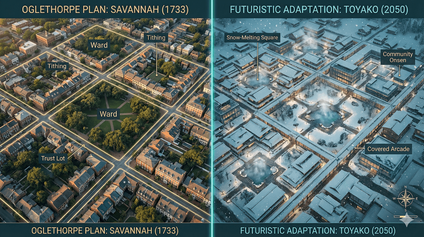
4. Application to Toyako Town, Hokkaido: The "Pocket Ward" Concept
So, is it possible to apply this 18th century urban planning to modern-day Hokkaido, for example, Toyako Town?
It is easy to dismiss the situation by saying, "The climate is different" or "The history is different," but Toyako Town is facing"Moving away from transit-based tourism"と"Vacant Houses and Vacant Land Issues"The Savannah Plan offers a surprisingly coherent solution.
A unique translation of the Savanna Plan's ideas for Hokkaido"Pocket Ward (Micro Square) Network Concept"We suggest:
▼ Target application area: Toyako Onsen town (around the main street)
4-1. Redefining "vacant lots" as "the nucleus of the city"
Currently, Toyako Onsen town is dotted with abandoned hotel sites and unused land, which are generally considered to be "negative assets that spoil the landscape."
But from Savannah's perspective, these"Possible site for future square"It is nothing but that.
Specifically, the vacant land along the main street was deliberately left unbuilt."A small square surrounded on three sides by walls (existing buildings and windbreaks)"It will be maintained as such.
Lake Toya has a vast open space called the lakeside, but it is linear, windy, and not suitable for staying there in winter.
In contrast, city squares are "planar" and surrounded by buildings, making them less susceptible to the effects of wind and thus capable of becoming "outdoor living rooms."
4-2. Turning snow into an ally: a reversal of the idea behind the "Winter Plaza"
The most important difference between a savanna and a mountain is the snow. However, this can also be reversed.
Small squares are"Planned snow dumping area"It can function as.
Rather than simply piling up snow, the snowy mountains are designed as a landscape and used as a venue for snow candles and as a shelter to block the wind.
Rather than being a "park that gets in the way of snow removal," the plaza serves as "infrastructure that helps with snow removal and also serves as a winter play area." This could be a new solution for urban planning in northern regions.
Conclusion: Cities are shifting from "functions" to "places to be."
A vision of the future revealed by wisdom from 300 years ago
Urban planner Jane Jacobs once said, "The safety of city streets depends on the eyes of the people who live there."
The reason why the Savannah Plan has retained its value for 300 years is precisely because of thisThis is because the "places where people's gazes and activities intersect" have been intentionally and dispersedly arranged.It is nothing but that.
What will be required of cities in the future is not just efficiency in terms of how smoothly cars can move around.
Beyond being "walkable," the city should be "sittable."
It is a process of transforming a road that people simply pass by into a place where people can stop and exchange words.
The seeds of the utopia dreamed by James Oglethorpe have the potential to sprout as new "urban cells" even in the faraway land of Hokkaido.
Should we view the vacant lots in our cities as mere empty spaces, or as the heart of future communities? This shift in perspective will be the first step in revitalizing local cities.
Related Links
- Design Manual for the Savannah Historic District
- Congress for the New Urbanism: The Oglethorpe Plan
- Ministry of Land, Infrastructure, Transport and Tourism: "Walkable" - A comfortable downtown area that makes you want to walk
Inquiries and requests
We help solve local issues.
Please feel free to contact us even if it is a small matter.


