〜Reinterpreting Southern European ventilation systems as snow accumulation spaces in northern Japan: new possibilities for urban development〜
*This article is based on information as of January 2026.
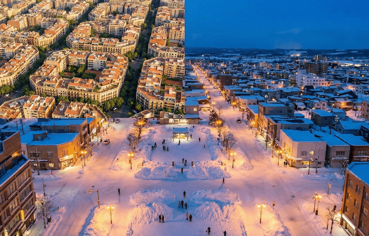
Seen from above, Barcelona's cityscape unfolds as if drawn by a ruler, a geometric tapestry. The orderly arrangement of square city blocks and the sharply cut corners of the octagonal grid are not simply the product of aesthetic design.
These are the remains of a massive, meticulous "urban surgery" designed to save the city from a serious sanitation crisis in the 19th century. It was designed by Ildefonso Cerda, who redefined the word "urbanization" for this project, and who aimed to bring "equality of light and air" to everyone, regardless of wealth.
Now, let's move forward to the present day and move our location to Toyako Town, Hokkaido, at the northern tip of Japan. In this area, which is simultaneously hit by two waves of population decline and recovering inbound demand, the idea of "chamfering corners" left behind by Cerda some 165 years ago holds extremely modern hints for solving the problems we face today: the nuisance of "snow" and the challenge of "maintaining a lively tourist destination."
In other words, it is an attempt to reinterpret the southern European "devices for letting wind pass through" as the northern "pockets for catching snow." From the perspective of a strategic partner, this paper reinterprets Barcelona's knowledge to suit the actual situation in Hokkaido, and discusses an urban engineering approach that balances capital maximization with relationship design.
1. What is the "Cerda Plan"? Urban surgery for light and air
Escaping suffocating cities
To understand why Barcelona has such an unusual shape, we need to understand the harsh conditions that Barcelona found itself in during the mid-19th century.
At the time, Barcelona was in the midst of the heat of the Industrial Revolution and was literally a "suffocating city." The old town, surrounded by walls dating back to the Middle Ages, was overflowing with workers seeking work, and records from the mid-19th century indicate that the population density reached 856 people per hectare, an abnormally high level of overcrowding—more than twice that of Paris at the same time (less than 400 people).
What happened as a result? High density and a lack of sanitary infrastructure such as water and sewage systems created a breeding ground for epidemics. Statistics from 1837 to 1847 (average for men) show that the average life expectancy of the wealthy was 38.3 years, while that of the poor was an extremely low 19.7 years.
Against this backdrop of a sense of stagnation, the removal of the city walls became an urgent issue for the sake of public health and the survival of its citizens, even before the city's development, as symbolized by the book "Abajo las Murallas" (Tear Down the Walls) written by the physician Pedro Felipe Monrau.
Urban Planning as a Science
The demolition of the city walls was initiated by royal decree in 1854, and then in 1859 a public competition was held and the architect Rovira's design was popular among the citizens, but in the end the central government was forced to adopt the "scientific grid plan" by civil engineer Ildefonso Cerda, which was put into operation in 1860.
Cerda redefined cities not as symbols of authority but as "machines for living in." He conducted thorough statistical research and calculated that "each person needs six cubic meters of fresh air per hour to live a healthy life." The "Cerda Plan" translated this figure into the physical structure of the city.
Ildefonso Cerda's words
"Urbanization is the adjustment of the relationship between space and its inhabitants to promote their physical, mental and moral well-being.
Sunshine and fresh air are rights that rich and poor alike should enjoy."
Manzana geometry
Cerda proposed a "grid structure without a center" consisting of an infinite series of 113.3m square city blocks (manzanas). Of particular note is the "chamfered" shape, with the four corners cut off at 45-degree angles.
The length of each side, the width of the road, and the height of the buildings were all designed based on scientific evidence, and the distinctive 45-degree corners were explained as a result of considerations such as ensuring visibility at intersections and the turning radius of the steam trams that were planned at the time.
▼ Barcelona's Eixample district (the octagonal grid can be seen from above)
2. Barcelona and Sapporo/Toyako: A Comparative Analysis of Grid Cities
Interestingly, Hokkaido's urban planning, especially the grid pattern of Sapporo, also has a grid structure that was planned by the Hokkaido Development Commission during the Meiji period. Here, we will quantitatively compare the grids of Barcelona and Hokkaido.
Comparison of Japanese and European grid structure data
*Please scroll horizontally to view the table below.
| Comparison items | Barcelona (Cerda Plan) | Hokkaido (Sapporo, Lake Toya, etc.) |
|---|---|---|
| Block size |
113.3m x 113.3m (approx. 12,800㎡) |
Approximately 109m x 109m (60 ken x 60 ken / shakkanho) |
| road width |
Standard 20m (Main lines are 30-60m) |
Diverse (Odori Park and other areas have a 105m fire line.) |
| Corner processing (Corner cutting) |
Chamfer Scale: hypotenuse approx. 20m (There are various theories depending on the definition and source) |
Corner cutting Scale: base 2-3m (*Based on local government standards) |
| Design Intent |
Visibility and turning radius Creating a plaza and accommodating trams |
Inner wheel difference/safety Smooth vehicle traffic |
As can be seen from the table above, the block sizes of Barcelona and Sapporo (Hokkaido) are miraculously almost the same, despite being designed according to different standards, the metric system and the shakkanho system. However, the crucial difference is in the way corners are treated.
In Japan, corner cutting is generally based on development standards and ordinances that require vehicles to turn at different speeds. In contrast, Barcelona's chamfers are enormous, with some sources describing the hypotenuse of the corner as approximately 20 meters (or the cut length), and by boldly cutting away the corner of the block, the intersection itself is defined as a "public space (plaza)."
Visual comparison of block shapes (image graph)
A simple graph shows how much the corners of the blocks have been cut and the resulting difference in "spatial margin."
*Please scroll horizontally to view the graph below.
*Conceptual comparison of the effective open space area created per intersection (may vary depending on the dimensional definition used as the basis for calculation)
3. The merits and demerits of "corner cutting" and its modern reevaluation
This huge corner cut is the greatest innovation of the Cerda Plan. It transformed the intersection from a simple "passing point" into an "octagonal plaza." However, there are clear advantages and disadvantages to applying this structure to Hokkaido as is. Let's organize them from various perspectives.
- Complete elimination of blind spots
Wide-open intersections dramatically increase mutual visibility between drivers and pedestrians. While Cerda designed them for the turning radius of steam trams, they also reduce the risk of intersection accidents in modern automobile traffic. - ● Creating an impromptu "plaza"
The spaces created at the four corners of the intersection can be used for multiple purposes, such as a cafe terrace, a bicycle sharing port, or a loading and unloading space for delivery trucks. The ability to create "public space" without having to acquire new land is an extremely valuable asset for the government.
- Severe "building winds" and ground blizzards
While ventilation is a virtue in Barcelona, it is a threat in Hokkaido's winters. Wide, unobstructed intersections are exposed to strong winds, triggering whiteouts and posing a risk of significantly lowering pedestrians' perceived temperatures. - Walking distance and psychological burden
Wider intersections mean longer crosswalks. For elderly people and pedestrians walking on winter roads, the increased physical and psychological distance can be a significant barrier.
Modern Barcelona's challenge: "Superblocks"
Furthermore, Barcelona is currently conducting a social experiment called "Superillas" that utilizes this grid structure. This involves grouping together nine 3x3 city blocks, restricting through traffic on the internal roads for general vehicles, and slowing down speeds within the area (such as to 10-20 km/h or less).
This will transform roads from "space for cars" into "living spaces for people," reducing air pollution and noise and reviving lost community ties. This paradigm shift from "car-centric to people-centric" is in line with Japan's promotion of walkable cities.
4. Application to Toyako Town: From ventilation holes to "snow pockets"
So how can we apply this knowledge to Toyako Town, our field of activity? Toyako Onsen Town is also a tourist destination with a planned grid structure.
The key is to reframe your goal: instead of "letting the wind through," you want to "hold the snow."
▼ Toyako Onsen Town (You can also see the grid-like division of land here)
Absorbing the cost of snow removal with space
For Hokkaido's local governments, the cost of snow removal and disposal in the winter is one of the biggest financial strains. Particularly problematic are the high piles of snow near intersections. Not only do these piles obstruct the view of drivers and pedestrians and are a major cause of accidents, but they also require significant labor, fuel costs, and CO2 emissions for snow removal (the task of transporting snow long distances by truck).
This is where the Cerda-style giant corner cut comes in. By expanding the intersection corner from the current legal standard in an expansive and operational manner, the area becomes a "snow pocket."
During the winter, snowplows can temporarily push snow into these pockets. This allows for clear visibility at intersections (site triangles) without narrowing the road width, and reduces the frequency of snow removal by trucks. This is truly a "structural design" that prevents capital outflows (snow removal costs).
A "tourist terrace" in summer and an "infrastructure buffer" in winter
The true value of this approach lies in its adaptability depending on the season, making it possible to use the space in a dual-cropping manner to suit Hokkaido's four seasons.
"Accommodation tax" as a source of revenue and investment in the future
Such urban structural reforms require funding. This is where the "accommodation tax" comes into focus. Hokkaido has already announced that it will be introduced on April 1, 2026 (Reiwa 8), and Toyako Town is also preparing to introduce the tax at the same time as the prefectural tax.
By investing the collected tax revenue in the development of these "variable public spaces" -- such as burying electrical wires underground, reorganizing city blocks, and widening sidewalks -- rather than simply spending it on road maintenance and repairs, it will be possible to reduce snow removal costs (cost reduction) and improve tourism value (top-line up) in the long term. Isn't this what strategic investment aiming to maximize capital looks like?
"Reducing Building Size" and "Creating Open Spaces" as Measures Against Vacant Houses
Furthermore, in this context, vacant houses that arise due to population decline can also be seen as an opportunity. Local governments and regional corporations could strategically acquire and demolish vacant houses on corner lots, and develop the areas into "corner-cutting plazas."
The land readjustment method that Cerda used in the past, when cities were expanding, can now be applied to "downsizing" in an era when cities are shrinking. This will address the issue of depopulation rather than overcrowding, providing residents with light, ventilation, and a safe place to store snow. This is not a "retreat," but rather "right-sizing" to a sustainable size.
Conclusion: Inheriting ideas, not imitating forms.
Barcelona's Manzana is beautiful not simply because of its beautiful shape. It has continued to function through the ages precisely because its shape was derived using all the science and logic of the time for the urgent purpose of "protecting the lives of the residents."
What we should aim for in Toyako Town, Hokkaido is not to simply copy the shape of Barcelona."Rewriting the rules of the land based on scientific evidence for the well-being of residents"This is the spirit of engineering that we inherit.
Snow, a uniquely local element, can be reincorporated from a "nuisance (liability)" to a "part of the system (asset)" in the city. The legal requirement of "cutting corners" can be hacked into a rich "public space." This is the urban engineering answer as a modern strategic partner that balances capital maximization with relationship design.
Related Links
- Ministry of Land, Infrastructure, Transport and Tourism: Walkable Portal Site
- Ajuntament de Barcelona: Superblocks (Superilles)
- Hokkaido Construction Department: Urban Development in Hokkaido
Inquiries and requests
We help solve local issues.
Please feel free to contact us even if it is a small matter.


