〜The logic and possibilities of "lines" being reevaluated across time and space〜
*This article is based on research information and historical documents as of January 2026.
Ever since humans began farming and adopted a settled lifestyle, the shape of cities has long been determined by three dynamics: defense, efficiency, and the symbolism of power. In ancient times, cities were "points" surrounded by strong walls to protect against foreign enemies, while in the modern era, cities have become "planes," sprawling uncontrollably into the suburbs in pursuit of economic efficiency since the Industrial Revolution.
However, at the origin of this long history of urban formation, the geometric form of "line" has always been on the table of discussion among urban planners as an innovative and somewhat unorthodox alternative. Why did they try to extend cities in a linear fashion?
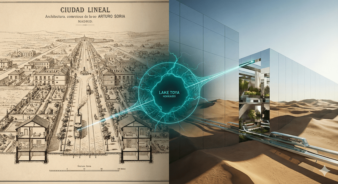
The linear city first emerged in Madrid, Spain at the end of the 19th century, captivated the Soviet Union and Le Corbusier in the 20th century, and is now emerging as a gigantic figure in the Saudi Arabian desert as "The Line" in the 21st century. This concept is not merely a utopian fantasy from science fiction. Rather, it is being reevaluated as an extremely realistic "spatial strategy" for rebuilding sustainable social infrastructure, especially in Japan's regional cities, which are being forced to retreat due to declining populations and the limits of infrastructure maintenance.
In this paper, we will go back in depth to the original ideas of the creator, Arturo Soria y Mata, trace its historical changes, and thoroughly analyze, based on data and logic, the possibilities for application in the specific field of Toyako Town, Hokkaido.
1. [Origin] Arturo Soria and the "Countryside in the Machine Age"
Let's rewind the clock to the late 19th century in Spain. At the time, the capital, Madrid, was caught up in the late waves of the Industrial Revolution and suffering from serious urban diseases. The population exploded as workers flocked to the city from rural areas in search of work, and unsanitary living conditions, widespread infectious diseases, traffic congestion, and soaring land prices due to speculation all put a strain on the lives of its residents.
In response to this, the engineer and urban planner Arturo Soria y Mata put forward a revolutionary thesis:"The form of a city should be determined by transportation."This was a very modern rationalist idea.
Soria is said to have publicly proposed his idea for the "Linear City" (Ciudad Lineal) in 1882, and it was presented and developed as an urban model throughout the 1880s. He asserted that the traditional "radial ring" type of city was the root of all evils that caused overcrowding in the center and sprawl on the periphery, and he presented the framework for an entirely new city.
Geometric definition: the tram as a spine
The structure is governed by a surprisingly rigorous geometry. Soria's urban specifications are as follows:
- City width: 500 meters
The area will be within a 5-10 minute walk from the central axis to the edge. The width will not be increased any further, and growth will be handled by "length." - Central axis (spine): 40 meters wide
Trams and railways are laid in the center, forming the spine of the city, with tree-lined streets, sidewalks, and infrastructure. - Compartment: Geometric grid
All plots are rectangular or trapezoidal, eliminating irregular alleyways.
"Turning cities into rural areas and rural areas into urban areas"
(Ruralizar la ciudad y urbanizar el campo)
For Soria, the tram wasn't just a means of transportation, but the circulatory system that pumped the blood through the city. He envisioned a life in which all residents would live in their own houses with their own gardens, with modern transport just outside their front doors and farmland and forests just outside their back doors.
The Google Map below shows Calle de Arturo Soria, which was actually constructed on the outskirts of Madrid. Although only about 5km of the original grand 50km plan was realized, traces of it remain to this day as a boulevard with abundant green spaces.
Howard the "point" vs. Soria the "line"
The twin pillars of urban planning at the end of the 19th century were the "Garden City" proposed by Ebenezer Howard of England. Both aimed for "coexistence with nature," but their approaches were as different as oil and water.
| Comparison axis | Linear City (Soria) | Garden City (Howard) |
|---|---|---|
| Basic form | Network type (band type) Development will be achieved by "connecting" existing cities with transportation hubs. |
Cluster type (satellite) Create an independent "point" away from the mother city. |
| Growth Strategy | along the axisInfinitely stretchabledo. (Cádiz to St. Petersburg) |
Once it reaches a certain size,New city in another locationConstruct. (Cytotoxic proliferation) |
| Distance from nature | back to back The back door of the house leads directly to farmland and the natural environment. |
Enclosure The city is surrounded by a green belt, with a park at its center. |
| social thought | Transportation supremacy Freedom of movement reduces class differences. |
Community supremacy Autonomous communities where people live and work close together will change society. |
While Howard sought to "escape" from the overcrowded city of London, Soria aimed to "connect" existing cities through transportation infrastructure. This idea of "networking by lines" can be said to be the forerunner of modern MaaS (Mobility as a Service) and wide-area collaboration.
2. [Present] The Ambitions and Contradictions of Saudi Arabia's "THE LINE"
In the 20th century, the idea of the linear city crossed national borders and produced various variations. In the Soviet Union, Milyutin applied it to the efficiency of industrialization as an "industrial band city," and in Japan in 1961, Kenzo Tange envisioned a huge urban axis stretching over Tokyo Bay to Kisarazu in his "Plan for Tokyo 1960."
However, most of these ideas never came to fruition. Then, in the 21st century, linear cities suddenly made a comeback as the largest practical experiment in human history within the megaproject "NEOM" led by Saudi Arabia's Crown Prince Mohammed bin Salman. This is "THE LINE."
From horizontal to vertical: A decisive departure from Soria
THE LINE is connected to the Soria lineage in that it is "linear," but its spatial composition and philosophy are not the same as those of the 19th century models. The biggest difference is the shift from two dimensions (flat) to three dimensions (vertical).
THE LINE Spec Summary (based on official announcement)
- full length:170 km (Equivalent to the area from Tokyo Station to Iwata City, Shizuoka Prefecture)
- width:200 m (Less than half of the Soria proposal)
- height:500 m (A wall higher than Tokyo Tower)
- outer wall:Fully mirrored glass (Reflections of the desert landscape)
- traffic:Realizing "20 minutes from one end to the other" with underground high-speed railways, etc.
The "paradox of movement" created by geometry
This ambitious project has drawn sharp criticism from urban engineering and mathematics researchers around the world. In particular, the "mathematical contradictions in mobility efficiency" pointed out by a research team from the Complexity Science Hub in Vienna (CSH) and others point out the inherent vulnerability of linear cities.
The graph below conceptually shows how differences in shape affect the average distance between two random points in cities with the same area and population.
Comparison of city shape and average travel distance
(The Circle)
(The Block)
(The Line)
*Conceptual diagram based on CSH research paper
Mathematically speaking, a circle (compact city) is the most efficient way to travel, and the more linear the area is stretched, the greater the cost of traveling from one end to the other. The official explanation for THE LINE is that it will be possible to travel in 20 minutes using underground high-speed rail, but if part of the system stops working, there is a risk that the entire city will cease to function (single point of failure).
Soria's goal of "improving the efficiency of movement" ended up creating a vulnerability in the form of "excessive reliance on the system" due to its extreme linearization and enormous size.
3. [Future] Application to Japanese Regional Cities: The Challenge of Toyako Town, Hokkaido
So, is the concept of linear cities merely a testing ground for large oil-rich nations, or a relic of the past? Let's now shift our focus to Toyako Town, Hokkaido, a regional city in Japan.
Population decline, aging, rising infrastructure maintenance costs... As Japanese local governments face these challenges in an "age of decline," the logic of linear cities is showing surprising affinity as a tool for "withdrawal and reorganization" rather than "development."
Case study: A decentralized town with three cores
Toyako Town was formed in 2006 by the merger of the former Abuta Town and the former Toya Village, but its structure is geographically divided into three major areas.
| District name | Key Features | Challenges |
|---|---|---|
| ① Abuta area (Former Abuta Town Center) |
Administration and living base Town hall, JR Toya Station, fishing port, public housing, supermarket |
Responding to tsunami risk, decline in commercial functions, and increase in vacant houses. |
| ② Hot spring area (Lake Toya Hot Springs) |
Tourist hub Large hotels, bus terminal, sightseeing boats, restaurants |
Declining guest numbers, disposal of dilapidated abandoned hotels, and labor shortages. |
| 3. Toya area (Former Toya Village) |
Agriculture and Nature Center Farmland, campsites, nature experience facilities |
The increase in abandoned farmland due to the aging population and poor transportation access. |
Due to topographical constraints such as mountains and lakes, these areas are forced to be connected in a linear fashion by National Route 230 and prefectural roads. It would be nonsense to build a continuous wall like THE LINE here, but Soria's idea of "connecting through transportation axes" is a powerful weapon for the town.
Proposal of the "Beaded Linear City" model
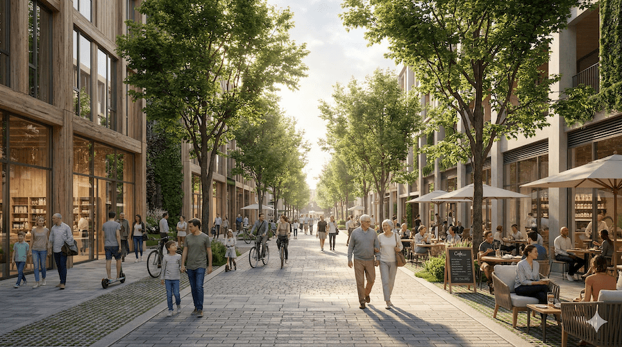
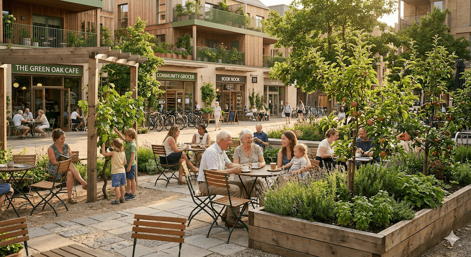
What we propose is not continuous development, but to connect the three existing cores (beads) with a strong transportation and information axis (thread), and to intentionally "ruralize" the areas between them."Beaded Linear City"I'm a model.
Strategy A: Modern Spine "MaaS and Mixed Cargo and Passenger Carriage"
The role that trams played in Soria's time is now played by digitalized bus transportation.
Local bus routes are in the red and have been reducing their service, but to maintain this, we will utilize the "wallets of tourists." By introducing a "mixed-ride system" in which high-paying tourists and publicly subsidized local residents ride in the same vehicle, and by also using it for logistics (transporting vegetables and fresh fish), we can maintain the frequency of service. This will create a psychological proximity that allows access without waiting, even if there is physical distance.
Strategy B: Complete suppression of ribbon development
A typical example of a failed linear city is "ribbon development," where shops and houses are lined up along an axis (road). In Hokkaido, a particularly snowy region, thinly spread development areas directly lead to increased snow removal distances and costs, putting pressure on local government finances.
therefore,"We will not develop the area between the cores."This requires a paradoxical courage: creating strict "agricultural and nature conservation zones" along national highways and restricting new construction. This will create a beautiful scenic byway during travel, while providing a sense of balance between enjoying urban services at the destination. This is a modern and financially viable interpretation of Soria's dream of "ruralizing the city."
Circulation design using local digital currency
Furthermore, we will implement a "regional digital currency (e.g., Touya Coin)" to facilitate this linear movement.
- tourist:The more you travel, the more points you earn, which you can use to buy local produce.
- residents:Earn points by using the bus or walking for a healthy lifestyle and use them in the shopping district.
- Data utilization:Visualize people's movements (flow data) and optimize bus schedules and snow removal plans.
In this way, the key to linear cities in the 21st century is to make the lines thicker not only through hard things (roads and buildings) but also through soft things (currency and data).
Conclusion: A path of hope drawn by "lines" in an era of shrinking
Arturo Soria y Mata's late 19th-century dream of the "linear city" is being swallowed up by waves of urban expansion in Madrid and is being transformed into a technological wall of immense proportions in Saudi Arabia.
However, the essential value of linear cities does not lie in their unusual shapes."Fully integrate transportation infrastructure and land use."Systems thinking, and"Urban functions and the natural environment coexist side by side"This is an ecological ethic.
Due to population decline, it is becoming impossible for regional cities in Japan to maintain their urban areas as a single "plane." The idea is to re-condense scattered settlements into a single, strong axis of life and tourism (the "spine"), and reclaim the vacant land as a rich natural environment. This is a beautiful yet rational retreat strategy for "folding up" the city.
"Turning cities into rural areas and rural areas into urban areas."
We are now trying to weave an answer to that question posed by Spain 140 years ago from the field of regional revitalization.
Related Links
- Ministry of Land, Infrastructure, Transport and Tourism: Promotion of Compact Plus Networks and Examples
- NEOM Official:THE LINE – The Future of Urban Living
Inquiries and requests
We help solve local issues.
Please feel free to contact us even if it is a small matter.