〜How did the subway-linked "ABC model" come about, and how does it address modern challenges?〜
*This article is based on information as of February 2026.
"A city cannot be just a collection of houses. It must have a sense of civic pride and a cultural soul."
This was a common understanding among thinkers who had a major influence on urban planning in the 20th century, and it was also the aspiration of the architects who led Sweden's post-war reconstruction.
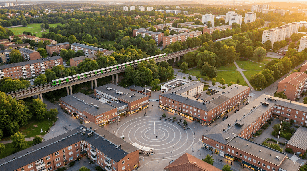
A historic ceremony took place in Vällingby, located about 10 kilometers west of Stockholm, Sweden, on November 14, 1954. The town was officially opened by then Prime Minister Tage Erlander, and it is recorded that around 100,000 people flocked to the venue.
What they witnessed was not just a suburban residential area (bedroom community), but a fully self-sustaining city, with workplaces, residences, and cultural facilities such as theaters and libraries all integrated around a subway station.
More than 70 years have passed since then. While many new towns in Japan are struggling with rapid aging and becoming old towns, why has Velingby managed to maintain its status as a desirable place to live and achieve revitalization? And what ray of hope does this insight shed on regional cities in Hokkaido, which are facing population decline and harsh winters?
In this article, we will dissect the deeper aspects of the "ABC model," which is considered a milestone in the history of urban planning, and explore concrete paths to "Shrinking Smart" in modern Japan.
1. Historical Inevitability: The 1952 Master Plan and the "String of Pearls"
Sven Markelius and Decentralized Growth
In the late 1940s, Sweden, which had escaped the ravages of World War II, was experiencing industrial development and rapid urbanization as a neutral country. Overcrowding in central Stockholm (the Norrmalm district) had reached its limit, and a housing shortage had become a serious social issue.
Sven Markelius, head of urban planning at the time, was influenced by the trends of CIAM (International Congress of Modern Architecture), but he sought a growth model that was more suited to Sweden's social structure than simply building high-rise buildings. While he was involved in the redevelopment of the city center, he strongly promoted "decentralized growth" in the suburbs as a system design that synchronized subways with local hubs.
The subway is the backbone of the city
The answer was the legendary master plan, the General Plan of 1952, which was formulated in 1952.
The highlight of this plan was the "perfect synchronization" of urban development and transportation infrastructure. Specifically, it involved building a subway (Tunnelbana) network radiating from the city center, with independent communities (satellite cities) located at each station, separated by green spaces. When viewed on a map, this concept was dubbed the "String of Pearls" (Pärlbandet), as it looked like jewels strung together on a green thread.
What's particularly noteworthy is the order in which this was done. The subway was extended to Vellingby before residents began moving in (1952), and the station initially began operating as a temporary station. The full-scale station facilities and centre were completed in 1954, marking the official opening. "Build a railway before people move in." This golden rule was decisive in preventing subsequent reliance on cars.
▲ Vellingby is located about 10km west of central Stockholm on the Green Line of the subway.
2. The full picture of the ABC model: a social experiment in proximity of work and home
When talking about Vellingby, it is essential to mention the "ABC model," which is an acronym for the Swedish words for this model. This was not simply a list of functions, but a system that embodied the "welfare state for all (Folkhemmet)" that the social democratic government of the time aimed for.
A – Arbete (Work): Escape from the city where you go to sleep
At the time, the conventional wisdom in suburban development was to create a "bedroom town" for commuters to the city center, but Vellingby resisted this.
With a focus on securing employment within the local area, the plan incorporated office functions for the power company and other businesses, as well as a light industrial zone with a low environmental impact. This has resulted in people commuting in the opposite direction to work in Velingby, rather than just heading to the city center during the morning rush hour, thereby dispersing traffic load and fostering a sense of belonging to the community.
B – Bostad (Housing): A density gradient that embraces diversity
In housing planning, a uniform enumeration of housing complexes was avoided and a "concentric density gradient" was adopted.
-
Walking distance from station:
High-rise apartment buildings (point houses) and mid-rise housing complexes are designed to accommodate singles, couples, and seniors, allowing them to live without using a car. -
Outer edge:
Terrace houses and low-rise apartment buildings. Continuity with gardens and green spaces was emphasized for families with children.
This layout makes it possible for couples to move within their familiar neighborhoods even if their life stage changes (for example, when their children move out and they become just a couple).
C – Centrum: Culture makes citizens
Vällingby Centrum is more than just a shopping mall: it's a "city hall with no roof" and a community hub.
A library, a cinema, a church, a community centre and a medical centre were all located around the square in front of the station. In particular, the civic cultural facility "Trappan" opened in 1956, a little after the town's founding, and continues to function as a hub for local cultural activities to this day.
3. Data comparison: Vellingby vs. Japanese new towns
The philosophy of Velingbee also influenced Senri New Town and Tama New Town, but their subsequent paths have been very different. We will examine what made the difference between success and failure using specific comparative criteria.
*Please scroll horizontally to view the table.
| Comparison items | Vellingby (Sweden) | A typical new town in Japan |
|---|---|---|
| Land Sovereignty |
[Planned monopoly and leasing system] The city will own the land and lease it to developers on a long-term basis, allowing the city to exercise strong leadership in redevelopment even half a century later. |
[Condominium sales and privatization] Land and buildings are subdivided and sold separately, making the rights complex. Even when buildings become dilapidated, it is extremely difficult to reach an agreement on rebuilding. |
| Transportation Infrastructure |
[Subway-first model] When the station was first occupied (1952), service began at a temporary station, and the station building was completed in 1954. From the early days, a "car-free lifestyle" became established. |
[Train-following type] In many cases, it takes several years to even decades from the time people move in until the railway opens, and during that time, a lifestyle dependent on private cars becomes established. |
| urban structure |
[Finger Plan] The high-density development centered around the station and the preserved green space (green wedge) that stretches out behind it interlock like fingers. |
[Surface sprawl] Mountains are cut open and residential areas spread out in a flat pattern. Areas far from stations are dependent on buses, making it difficult for elderly people to get around. |
| Commercial Functions |
[Wide-area base] The revitalization of the area in the 2000s led to its successful expansion into a regional shopping center, attracting customers from the surrounding area and maintaining its economic independence. |
[Decline of neighborhood centers] The shopping district within the housing complex has become deserted, and is losing customers to large malls along the suburban bypass. |
Visual comparison of travel share (modal share)
The graph below compares the proportion of transportation methods in the Stockholm area and regional urban areas in Japan.
■ Comparison of transportation means share (actual values)
The graph can be scrolled horizontally.
Source: Resvaneundersökning 2019 (Region Stockholm) / Nationwide Urban Transport Characteristics Survey 2021 (Ministry of Land, Infrastructure, Transport and Tourism)
Survey results show that the share of people using cars in the Stockholm region as a whole is only 40%, and that in the western part of the city (Västerort), which includes Väringby, public transport use reaches 39%.In contrast, in Japan's regional cities (weekdays), car use exceeds 60%, highlighting the fact that urban structure determines people's means of transportation.
4. Contemporary Challenges: Regeneration into a "Vellingby City" and Multicultural Coexistence
However, even ideal cities age. In the 1990s, Vellingby faced two major crises: the deterioration of its facilities and commercial obsolescence, and social changes brought about by an influx of immigrants.
Preserving history while injecting newness
In the early 2000s, Stockholm's housing authority embarked on a major regeneration project, and what's remarkable here is that it didn't opt for a "scrap and build" approach.
The restoration was carried out while respecting historical buildings (K-märkt) such as the Trappan (cultural facility) and the distinctive landscape elements of the 1950s. On top of that, the modern-looking fashion building "K:fem" was added. This contrast between old and new transformed the city's outdated image into a "retro-future" charm, and succeeded in attracting young people from a wide area back to "Vellingby City."
Fighting an invisible wall
On the other hand, social division is difficult to solve. Western Stockholm, including Vallingby, is becoming increasingly multicultural and multiethnic. While this brings vitality to the city, it also creates segregation of residential areas due to income disparities and differences in unemployment rates.
In response to this, the local government is focusing on "integration" not only in terms of hardware but also in terms of software, such as holding events in the square and establishing an employment support center for young people. The litmus test for the future will be whether the square can continue to function as a "social node" where people of different backgrounds can naturally interact.
5. Proposal: "Snow Country ABC Model" in Toyako Town, Hokkaido
Finally, we will consider how to apply this Nordic wisdom to our field, Toyako Town, Hokkaido, and propose "aggressive urban planning" in a shrinking society.
The era of attracting large factories is over. The "A" in Toyako is the fusion of tourism and local life.
For example, the tourist information center could be equipped with a "co-working space for residents" and an "agricultural product processing lab." By opening up tourist facilities as workplaces for residents, we can create employment opportunities that are resilient to seasonal fluctuations.
We present the powerful benefit of "If you come here, you won't have to shovel snow."
We will designate central areas where functions are concentrated as priority snow removal and road heating zones, and encourage elderly housing there. Rather than forcing residents to relocate, we will promote natural "downsizing" by using winter comfort as an incentive.
C (Central) × TOD: Bus stop "station" transformation project
In Toyako Town, which does not have a subway, the replacement for Velingby's Tunnelbana is an "advanced bus system."
The current "bus stops where people wait in the cold" should be evolved into "waiting stations equipped with heating, Wi-Fi, and parcel lockers." These will not be just bus stops, but small "centres" where local residents can get warm and exchange information.
When the time spent waiting for the bus changes from a "pain" to a "time for interaction," public transportation will regain its function as the backbone of the community.
Conclusion: Cities are shaped by "intentions"
What we should take home from our visit to Velingby is not sophisticated design drawings, but the underlying strong will to "leave the kind of society we want to leave to the next generation."
Our Swedish ancestors connected the often-separate areas of "work, living, and leisure" with a single thread: the subway. As Japan faces the harsh winter of population decline and aging, what we need is the determination to reunite our fragmented administrative functions and communities under a vision of "consolidation."
Toyako Town boasts a world-class landscape. If we can add the script of "walkable living," it will become a new "ABC model" for Japan and serve as a guidepost for the future.
Related Links
- Ministry of Land, Infrastructure, Transport and Tourism: Sustainable urban development and public transportation
- Region Stockholm: Travel habits surveys
Inquiries and requests
We help solve local issues.
Please feel free to contact us even if it is a small matter.


