〜How did Lucio Costa's airplane-shaped plan come about, and what reality did it face?〜
*This article is based on official data as of February 2026.
Drawing a line in a blank space on a map is the most ambitious and terrifying act for an architect, almost like an act of God.
Let's turn back the clock to the mid-1950s. At the time, Brazil was suffering from a chronic illness: population concentration on the coast and economic disparity. In an attempt to break through this sense of stagnation, President Joscelino Kubitschek put forward a reckless slogan:
"50 years of progress in 5 years"。
He set his sights on the Cerrado, an inland wilderness isolated from civilization. It was there, with its expansive red soil and shrubs, that he decided to transplant a new heart for the nation: Brasilia, the largest modernist experimental city in human history.
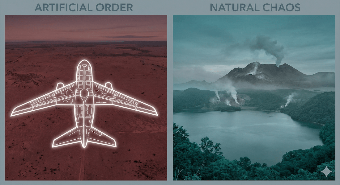
When viewed from above, this city resembles a gigantic airplane. What ideals were envisioned in the planning stages, and what did it face in the course of time? This article will explore Brasilia's construction process in detail, while attempting to draw a comparative urban perspective with Toyako Town in Hokkaido, which coincidentally shares a "frontier" background.
A thoroughly artificially planned city and a hot spring resort that coexists with the uncontrollable natural environment of an active volcano. It is in these two extreme contrasts that hints lie for the future of "maximizing capital" and "designing relationships."
1. "Cross" on the Red Earth: Lucio Costa's Philosophy and Strategy
First, we must understand that Brasilia was never a "spontaneous" city. It was the product of pure will and logic.
The impact of a simple sketch
In 1957, a competition was held to design the new capital city. With the world watching, many architects submitted proposals that were packed with detailed data, but it was not these that captured the hearts of the judges. The proposal that was selected was:Lucio Costa's proposal, consisting of only a few sketches and a brief reportThat was it.
Costa begins his report with a highly philosophical definition of the origins of cities.
"A city begins with a deliberate act of possession, like someone drawing a cross on the ground to reserve a place."
He gently curved one axis of this primitive "cross" to fit the local topography, like a sail or a bow. This was the birth of the famous "Plano Piloto." This shape visually symbolized Brazil's desire for takeoff at the time, and resonated perfectly with the developmentalist zeitgeist.
Complete control of space with four scales
Brasilia's uniqueness lies in its strict separation of functions. Costa faithfully embodied the Athens Charter of the International Congress of Modern Architecture (CIAM) proposed by Le Corbusier, in fact even more purely than the original. He strictly classified urban space into the following four scales, and did not allow mixing of them.
| Scale Division | Overview and Functional Roles | Spatial characteristics and intentions |
|---|---|---|
| A. Monumental Scale (Escala Monumental) |
The "fuselage" part of an airplane. The central functions of the nation, such as the Three Powers Plaza, various ministries and agencies, and the cathedral, are concentrated here. |
A vast space that transcends the physical scale of humans. A place that visualizes the prestige of the "nation" and overwhelms individuals. |
| B. Residential Scale (Escala Residencial) |
The "wing" part of an airplane. It is made up of neighborhood units called "Super Quadra." |
A group of housing complexes floating amongst greenery. Pedestrians and vehicles are strictly separated, allowing residents to live without crossing the road. |
| C. Scale of Gathering (Escala Gregária) |
The intersection of both axes. Commercial, entertainment and bus terminals. |
It is the heart of the city and a place where people interact, but it is currently not functioning as a transportation hub. |
| D. Rural scale (Escala Bucólica) |
Green spaces and artificial lakes surround the city. Recreation and climate regulation. |
Roberto Burle-Marx's organic planting scheme brings moisture to the dry savanna. |
*The table can be scrolled horizontally.
In this way, each function was separated like a surgical operation. This was the result of eliminating "mixture" and "disorder" and pursuing the utmost in efficiency and hygiene, but at the same time it also led to the robbery of the city of its "labyrinth-like charm" and "chance encounters."
▼ Google Map: "Airplane-shaped" city shape seen from above
If you zoom out on the map, you can clearly see that the center is shaped like an airplane, with a curved edge.
2. Niemeyer's beautiful curves and the "Candungos" hidden behind the construction
If Costa created the framework of the city, it was the genius architect Oscar Niemeyer who breathed life into that framework.
"Right angles are man-made, but curves belong to God."
His buildings, while made of the heavy material concrete, have a lightness that seems to be liberated from gravity. The symmetrical dome of the Parliament Building and the Cathedral symbolizing praying hands function as poetic accents against the strict geometry of urban planning.
However, we must not forget that behind the construction of this utopia were tens of thousands of laborers known as "Candangos." They came from poor areas, mainly in the northeast, in search of hope, and supported the grueling, round-the-clock construction.
However, once the planned city was completed, there was no place for them to live. They were deemed no longer useful and were pushed out to the periphery, ironically forming unplanned "satellite cities." This created a microcosm of the division that Brazil faces today, between the wealthy city center and the poor periphery.
The gap between plans and reality: A graph of the population explosion
The construction of Brasilia was a national project that placed an enormous burden on the national finances, which ultimately contributed to the deterioration of the national finances and increased inflationary pressure at the time. Even more serious was the population explosion, which far exceeded predictions.
The graph below compares the original planned population with the actual population trends.
Difference between population trends and planned figures in Brasilia (Federal District)
Source: Created based on data from the Brazilian Institute of Geography and Statistics (IBGE)
The graph can be scrolled horizontally.
Contrary to the ideal of living close to work, many citizens are forced to commute long distances from satellite cities to the city center. The current situation is that airplane-shaped cities have so many people that they cannot fit on their wings, causing arteriosclerosis in the form of traffic congestion.
3. Comparative Urban Studies: Brasilia and Toyako Town, Hokkaido
Now, let's turn our attention to the other side of the globe, to Hokkaido, Japan. At first glance, the huge capital of South America and the tourist destinations of the northern part of the country may seem incomparable in terms of scale and functionality.
However, in terms of the historical background of "frontier development" and the fundamental question of "how to deal with nature," the two are like two sides of the same coin.
Rigid planning vs. adaptive development
Brazil's "March to the West" and Japan's "Hokkaido Development" since the Meiji era were both frontier integration processes led by the central government. However, their approaches to urban development, especially their attitudes toward nature, are polar opposites.
| Comparison items | Brasilia (Planned City) | Toyako Town (nature-adaptive) |
|---|---|---|
| Attitude towards nature | Overcoming and Overriding (Rigid) They bulldozed the fields, created artificial lakes, and "overwritten" the earth with a theoretical geometric order. Nature is something that needs to be managed. |
Symbiosis and Adaptive Accepting the risk of an eruption from Mount Usu, an active volcano, the town has been "transforming" to adapt to natural changes, including developing hazard maps and turning the town into a geopark. Nature is a formidable partner. |
| Economic infrastructure | Dependent on the national budget (consumption type) The city is primarily an administrative center, and huge federal subsidies are essential for maintaining the city. Its self-sustaining economic cycle is weak. |
Utilizing local resources (recycling) The city is primarily based on tourism and agriculture, and has an autonomous financial base funded by natural bounty, including a hot spring tax (approximately 120 million yen per year). |
| Intersection in 2008 | In 2008, Brazil (then representing emerging countries) participated in the Hokkaido Toyako Summit. This marked a symbolic and historic crossroads where a "representative of artificial cities" discussed environmental issues in a "city that coexists with nature." |
|
*The table can be scrolled horizontally.
What is particularly noteworthy is that while Brasilia tried to impose a "finished blueprint" on reality, Toyako Town has survived devastating natural forces, such as the 2000 eruption of Mount Usu, by flexibly changing its infrastructure and industrial structure.
For example, Toyako Town has chosen to leave the remains of the eruption intact and turned them into a tourist resource known as a "geopark." This is a good example of "resilience," which transforms risk into value.
▼ Google Map: Toyako Town, adjacent to a caldera lake and an active volcano
The position of the circular caldera lake with an island floating in the center and Mount Usu towering to the south.
4. Flight Plan for the Future: "Revised" for 2060
Long-term vision for 100 years of construction
More than 60 years have passed since its construction, and this once futuristic city is facing aging and institutional fatigue. Currently, the Federal District Government is looking ahead to 2060, the 100th anniversary of its construction,Subway extension, BRT (Bus Rapid Transit) system development, and pedestrian space reorganizationWe are gradually implementing our long-term urban restructuring vision, including the following:
This is not simply an infrastructure repair. It is an attempt to boldly incorporate public transportation into a road network designed with automobiles in mind, and to reclaim pedestrian-centered space. In other words, they are trying to transform what was once a "future city as hardware" into a "city that can be updated to suit the times."
There are also technical connections with Japan. Through the Japan International Cooperation Agency (JICA), Japanese universities and research institutes (including Hokkaido University) have a track record of providing technical cooperation in land readjustment and urban infrastructure development in Latin American countries. The know-how cultivated in Japan's cold-climate and frontier development has the potential to contribute in a different form to solving urban problems in South America.
Conclusion: Unfinished experiments teach us the importance of "white space"
The plane depicted by Lucio Costa has indeed taken off from the wilderness. However, a diverse range of passengers (citizens) not originally envisioned board the plane, forcing the destination to change from a "perfect utopia" to a "growing organic city."
The biggest lesson we can learn from the lessons of Brasilia and the contrast with Toyako Town is the importance of urban planning.The Importance of "White Space" and "Adaptability"What is needed is not a "rigid" plan that fixes a perfect solution from the start, but an "adaptive" plan that can adapt flexibly to changes in the times, the activities of residents, and the fury of nature.
"Capital maximization" does not simply mean building an efficient building in the shortest possible time. It is nothing other than designing the "relationships" that take place there, leaving room for potential, so that they will be sustainable 50 or 100 years from now.
The giant airplane painted on the red clay continues to quietly but powerfully ask us what a city should be like.
Related Links
- Ministry of Foreign Affairs: Basic Information on the Federative Republic of Brazil
- Lake Toya and Mount Usu Geopark
- JICA (Japan International Cooperation Agency): Cooperation in Brazil
Inquiries and requests
We help solve local issues.
Please feel free to contact us even if it is a small matter.


