〜Why is this technique, which has been used since the Meiji era, called "magic" and sometimes feared as "the devil"?〜
*This article is based on official documents and historical facts as of February 2026.
"The mother of urban planning" -- in the field of urban development in Japan, land readjustment projects are referred to with a sense of awe, or perhaps even a certain fear.
At times, it is praised as a "magic wand" that clears out disorderly slums and creates orderly modern cities, but at other times it is criticized as a "cold scalpel" that cuts apart ancestral land and inflicts unbearable pain on residents.
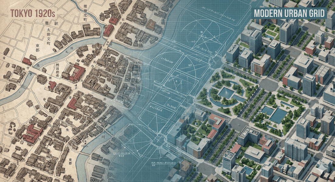
Marunouchi and Shinjuku in Tokyo, Hirokoji-dori in Nagoya, and new towns across the country - many of these orderly cityscapes did not emerge naturally, but were artificially and mathematically reconstructed through this project.
However, few people fully understand that this mechanism is based on a method that is rare even by global standards: residents' contribution of their private property (reduction). "Why does my land have to be reduced?" "Why doesn't the government buy up the land?" The answers to these questions lie hidden in 19th century German jurisprudence and the historical torrent of the reconstruction of the imperial capital after the Great Kanto Earthquake.
This article thoroughly examines the historical evolution of this system, which originated in Germany and was used by Goto Shinpei as a trump card in Japan's reconstruction, as well as its merits and demerits, and its most recent application in Toyako Town, Hokkaido, where "relocation to save lives" is being implemented. In modern Japan, where population decline and disaster risk are a concern, how should we approach and utilize this "mother" system?
1. The "magical" mechanisms and mathematics of reorganizing urban space
Definition: Aerial transfer of rights called "exchange of land"
The legal definition of Land Readjustment Projects is "projects related to the change of land parcel characteristics and the construction or modification of public facilities on land within urban planning areas, in order to improve and develop public facilities and increase the use of residential land."
However, this definition alone does not reveal the true essence of the project. The core of this project is that, unlike "Eminent Domain" where the government forcibly purchases land, it rearranges the shape and location of the land like a puzzle while maintaining the rights of residents (ownership, leasehold, mortgages, etc.).
The most important concept here is"Replotting"is.
| term | Definition and Role | Impact on landowners and legal consequences |
|---|---|---|
| Former territory (100th anniversary) |
The original land before the reorganization project began. | The roads are often narrow and irregularly shaped. |
| land exchange (Kanchi) |
New land after reorganization. Legally, it is "regarded as the previous residential land" (Article 104 of the Act). |
The location will be moved and the area will be reduced, but the facility will be reshaped and equipped with infrastructure. There is no need to rewrite the registration, and the mortgage is automatically transferred. |
| reservation land (Horyuuchi) |
Land that is not allocated to landowners but is sold by the project implementer to cover project costs. | Land created through the "pain" (reduction of land area) of landowners. Whether or not this can be sold at a high price will determine the success of the business. |
The logic of "genbu": Why is it not a loss if the amount of land is reduced?
The biggest point of contention in land readjustment is "contribution," which refers to the phenomenon in which the area of one's land is reduced by 20 to 30 percent after the project is completed.
Why is this acceptable?"Proportionality Principle"This is based on the legal and institutional principles of fairness inherent in land readjustment.
[Theoretical model: Omelette theory]
A common example is the omelet.
Eggs (undeveloped land) are cheap as they are. However, if you cook them into an omelet (developed land), the unit price (taste) increases dramatically, even if the quantity decreases slightly, and the total value increases.
[Illustration] Mechanism of asset value increase (theoretical value)
Unit price 10
Previous land
Total assets 1,000
Unit price 15
Land after reorganization
Total assets 1,200
*Scroll horizontally to see the details.
*The area will decrease by 20% (reduction), but if the unit price increases by 1.5 times due to infrastructure development, the total asset value will increase. This is called "increase."
2. History: From the Adices Law to the restoration of the imperial capital and post-war reconstruction
Origin: "Lex Adickes" in Frankfurt
At the end of the 19th century, Germany was in the midst of the Industrial Revolution. Frankfurt's housing supply could not keep up with the rapid influx of people. The reason for this was that land ownership was fragmented and complicated, making it difficult to build roads or buildings.
The mayor at the time, Franz Adickes, introduced a groundbreaking bill.
"We will have the local government take over all the land in the area, redraw the boundaries neatly, and then return it to the original landowners."
This law, commonly known as the "Lex Adickes," was enacted in Prussia in 1902. Initially, the upper limit on the amount of land that the government could secure free of charge for infrastructure use was around 301 TP3T, but this was later expanded to 351 TP3T to 401 TP3T, becoming a powerful engine for the formation of modern cities.
1923 Great Kanto Earthquake: Goto Shinpei's decision
The father of Japanese urban planning, Goto Shinpei, was interested in this German method.
On September 1, 1923 (Taisho 12), the Great Kanto Earthquake struck Tokyo, causing devastating damage. With the land reduced to burnt ruins, boundary posts gone, and no one knowing who owned the land, Goto Shinpei (president of the Imperial Capital Reconstruction Agency) decided that "now is the time to carry out land readjustment."
At the time, land acquisition was a complex process, with complicated rights and negotiating processes alone taking decades, making reconstruction impossible. Goto entrusted his dream of modernization, which he had envisioned in the "Tokyo Municipal Government Outline (commonly known as the 800 Million Yen Plan)" before the earthquake, to reconstruction during this emergency.
In the reconstruction land readjustment that was carried out,"Free step reduction 10%"Although it varied depending on the area, the total reduction rate reached around 15% (some sources say around 17%), but this resulted in the creation of major arterial roads that form the backbone of Tokyo, such as today's Showa-dori and Yasukuni-dori.
War-damage reconstruction and the "100m Road"
After World War II, the "War Damage Reconstruction Land Readjustment Project" was implemented in 115 cities across Japan that had been destroyed by air raids. Nagoya City is particularly noteworthy.
Anticipating the arrival of a car-oriented society in the future and the need for firebreaks, Nagoya City constructed 100-meter-wide roads (present-day Hisaya Odori and Wakamiya Odori) in the city center through land readjustment. At the time, there was criticism that "they're building an airport," but today these vast green spaces and road spaces are Nagoya's greatest assets, supporting its prosperity.
Map: The 100m Road, a symbol of post-war reconstruction (Hisaya Odori, Nagoya City)
The vast space secured through land readjustment is currently used as a park.
3. International Comparison: Japan and Germany: The Definitively Different Concepts of "Ownership"
The Japanese system was modeled on the German system, but after 100 years, the two systems have diverged to the point that they can be considered completely different. Behind this lies a crucial difference in legal philosophy regarding land ownership.
| Comparison items | Japan (Land Readjustment Project) | Germany (Umlegung / Baulandlegung) |
|---|---|---|
| Who will do it? (Enforcement entity) |
“Union enforcement”is the mainstream. In many cases, landowners form associations and run their own businesses. |
“Administration-led”is the basic principle. Local governments will take strong leadership in this effort. |
| Barriers to consensus building | Very expensive. The establishment of a union requires the number of landowners and the area of residential land.More than two-thirdsThe consent of the government is required, and it can take decades to persuade them. |
Relatively low. This can be implemented as an administrative measure based on city planning decisions. There is a strong tendency for public interest to take priority over private rights. |
| Cost thinking | "Self-sustaining"。 The ideal situation would be to sell the reserved land and cover the entire construction cost. This was highly valued as a way to develop the city without using tax money. |
"Public funding"is the premise. Infrastructure development is the responsibility of the government, and landowners' burden is limited. There is little thought given to selling land to raise funds for construction. |
| philosophical background | Absolute respect for private rights. The spirit of mutual aid: "Everyone loses a little, and everyone gains." |
"Social Obligations of Property Rights"(Basic Law). The strictness of the obligation of those who own land to serve the public welfare. |
In Germany, once a city planning decision is made, it becomes "legal" and binds the landowners. In contrast, in Japan, emphasis is placed on the "agreement" of landowners. This "democratic process" is what characterizes Japan, but at the same time, it can also cause projects to be prolonged and lead to deadlocks caused by some opponents (the holdout problem).
4. Pros and Cons: Asset Protection or Exploitation?
Land readjustment is an extremely rational method for government and developers, but for residents it can be the biggest gamble of their lives. Depending on your position, you will see completely different views.
Minimizing public expenditure and renovating urban infrastructure
-
✅ Dramatic reduction in fiscal spending
If the "reservation land" could be sold at a high price, roads, parks, and sewers could be built all at once with almost no tax money. This was once even called "alchemy." -
✅ Maximizing land potential
"Dead lots (such as cul-de-sac lots)" that do not meet the road access requirements of the Building Standards Act will be transformed into regular residential lots through land exchange design, which will raise the utility value of the entire area. -
✅ Community continuity
With the land acquisition method, only residents who fall on the planned lines are forced to move out, but with land readjustment, residents can continue to live in the area. A major advantage is that local festivals and neighborhood associations can be maintained.
Loss of assets and fragmentation of lives
-
⚠️ Loss of assets due to "reduction"
Since the collapse of the bubble economy, we have been living in a deflationary economy where land prices do not rise even when it is developed. As a result, the area of land has decreased by 30% while the price has remained flat, resulting in a simple decline in assets. -
⚠️ The pain of prolonged "temporary housing"
On average, these projects take 15 to 20 years. During this time, people are forced to move to temporary prefabricated housing sites, their ability to rebuild their homes is restricted, and their life plans are frozen. This is far too long for the elderly. -
⚠️ Settlement money and double loans
If the land's assessed value after land exchange is deemed too high, there is a risk of being charged a "settlement fee (collection fee)" of several million yen. In addition, cases where the cost of building a new home following relocation exceeds the compensation amount, leading to bankruptcy due to double loans, have become a social problem.
5. Toyako Town, Hokkaido: A survival strategy of "building a town for escape"
Here, we will introduce an example of town development under extreme conditions that goes beyond the context of urban development. Toyako Town, Hokkaido. Here, the single biggest mission was to "survive."
2000 Usu eruption: Why mass relocation was chosen over land readjustment
Mount Usu, towering behind the Toyako Onsen hot spring resort, is one of the world's most active volcanoes, having erupted four times in the 20th century alone (1910, 1944, 1977, and 2000).
The 2000 eruption caused severe crustal movements at the foot of the western volcano. The national highway rose in a stepped pattern, and many houses were destroyed or submerged. It is now physically impossible to live in the original locations.
In a normal land readjustment, the rights are transferred through "land exchange," but Toyako Town has taken a step further."Disaster Prevention Group Relocation Promotion Project (Boushu)"was adopted.
This is a method in which local governments purchase land in dangerous areas and relocate residents en masse to new housing complexes built on safe, elevated ground (such as the Senboku district). Unlike land readjustment, which involves "converting" rights, this method involves a one-time "liquidation (purchase)" of the land, but the goal of "evacuating the entire community to a safe place" is the same.
Map: Site of disaster and restoration (Toyako Town, Hokkaido, around the crater at the foot of Mt. Nishiyama)
Near the raised remains of the road is a new residential area that was developed by relocating people to higher ground.
On the other hand, in the reconstruction efforts following the Great East Japan Earthquake (in Iwate, Miyagi, etc.), land readjustment projects were widely used as a means of relocating people to higher ground.
The methods are different, but they are the same in Japan, a country prone to disasters."Pre-disaster recovery (planning how to escape before a disaster occurs)"Research is currently underway on these two pillars.
A necessity in the north: Land readjustment as a measure against snow
Furthermore, land readjustment in Hokkaido is faced with a serious problem: snow.
Snowplows cannot enter unpaved roads that are only four meters wide in winter. There is no snow storage area (snow belt), so the roads are buried in snow, making it impossible for even ambulances to pass.
Widening roads to over eight meters and creating wide sidewalks and green spaces through land readjustment directly means securing "snow removal space." Snow removal costs in Sapporo vary from year to year, but in years with heavy snowfall they can exceed 20 billion yen. Efficient block formation reduces these enormous maintenance costs and dramatically reduces the burden on residents of removing snow themselves.
Conclusion: From expansion to contraction: A new contract for a mature society
Land readjustment projects are undergoing a 180-degree shift in their role from a tool for expanding cities indefinitely (to combat sprawl) to a tool for collapsing and protecting cities (compact cities and disaster prevention).
As the population decline accelerates, land readjustment techniques are showing their true value in situations that could be called "end-of-life planning for cities," such as "land exchange" to gather scattered suburban residents into the city center, and "three-dimensional land exchange" (converting land rights into apartment floor rights) to free elderly people from land management.
The image of the imperial capital that Goto Shinpei dreamed of, and Toyako Town's determination to survive.
The underlying idea is that "an individual's land is their own, but at the same time, it is also part of the community that is the town."
If the topic of land readjustment comes up in your city, will you view it as a mere "burden" or "exploitation," or as an "investment" in the future? This shift in perspective will be the key to carving out a sustainable future for cities.
The "mother of urban planning" is now asking us a question.Who, where and how do you want to survive?and.
Related Links
- Ministry of Land, Infrastructure, Transport and Tourism: Land readjustment projects
- Urban Development and Land Readjustment Association: Land readjustment system
- Hokkaido Iburi General Bureau: Record of the 2000 Usuzan eruption
Inquiries and requests
We help solve local issues.
Please feel free to contact us even if it is a small matter.


