〜How can Kevin Lynch's concept of "imaginability" be applied in an age where Google Maps and AI are widespread?〜
*This article is based on information as of February 2026.
"We shape our buildings; thereafter they shape us." This is how former British Prime Minister Winston Churchill beautifully expressed the irreversible impact that physical space has on the human mind, behavior, and even the very structure of society in a speech to Parliament in 1943. In other words, the urban spaces we live in are not simply inorganic aggregates of concrete and asphalt, but are nothing less than gigantic devices that unconsciously define and shape the consciousness and behavior of the people who live there.
With this fundamental premise in mind, there is one classic work that cannot be avoided when discussing modern urban planning and city development. This is The Image of the City, a book by urban planner Kevin Lynch, published by the Massachusetts Institute of Technology (MIT) Press in 1960. The groundbreaking concept of "imageability" that he proposed in this book fundamentally reexamined the characteristics and capabilities of space, asking how clearly and easily the physical environment of a city evokes a mental map in the minds of observers (citizens and visitors).
However, times have changed dramatically, and since their introduction in 2005, GPS-linked digital maps such as Google Maps have dramatically changed our "navigation techniques." In an age where every location is reduced to digital "points" and routes are automatically optimized, the importance of physical signposts and the continuity of landscapes seems to have diminished at first glance. Has Lynch's theory really become a relic of the past due to technological advances?
The bottom line is that this is not the case at all. In fact, its importance is being reevaluated in a new context, especially in today's information-saturated world. In this article, we will build on Lynch's theory and compare it with modern AI and big data technologies, as well as the urgent challenges facing local communities. We will also delve deeply from multiple perspectives, comparing data from Japan and abroad, to explore the possibilities for new "placemaking" that is needed in an age where digital and physical spaces are merging.
1. A Copernican revolution in urban evaluation: from "beauty" to "understandability"
A paradigm shift brought about by imaginability
Before Kevin Lynch came on the scene, conventional urban planning and architectural design reigned supreme based on the "beauty of proportions" and "geometric style" seen from above, as exemplified by Le Corbusier. However, Lynch's ideas are thought to have been largely developed during his time in Tuscany, based in Florence from 1952 to 1953. While walking the complex, organic streets of the Middle Ages, he discovered a new approach based on the objective, psychological criteria of human perception. In other words, he successfully shifted the evaluation axis of urban space from the "formal beauty" of a select few experts to "clarity and legibility" for the people walking on the ground.
It is worth noting here that clarity of urban space does more than simply improve the convenience of transportation. It frees people from the fear of getting lost and other unconscious anxieties, and provides a solid foundation for nurturing psychological satisfaction and civic pride within a stable emotional environment. According to Lynch's theory, the image of the environment we have is strictly defined as consisting of three components: "identity," which states that an object is a unique and distinctive entity; "structure," which indicates the spatial and structural relationships between elements and the observer; and "meaning," which has practical and emotional significance.
Positioning and clear differences from similar concepts
Expanding on this, Lynch's "imaginability" is often confused with "placemaking," a term frequently used in modern urban development, and the "Landscape Act," a legal system unique to Japan. However, there are clear differences based on the philosophies underlying their respective focuses and evaluation criteria. The table below provides a detailed summary of the differences in each of their objectives, evaluation criteria, and approach methods.
| Comparison element | Imaginability (K. Lynch's concept) |
Placemaking (Modern space creation techniques) |
Landscape Act (Japanese regulations and plans) |
|---|---|---|---|
| Main Objective | By ensuring the legibility of urban spaces and forming solid cognitive maps in people's minds, it brings about deep psychological stability. | By fostering a sense of place in the space and intentionally creating functional and social vitality, we can create a sustainable community. | The purpose of the law is to create and preserve beautiful landscapes and to create "a beautiful and dignified land and a rich and pleasant living environment" (from the purpose of the law). |
| Evaluation axis | The evaluation places the greatest emphasis on human subjective "perceptual structures," such as the visual clarity of the space, the strength of elements, and the ease with which a sense of direction can be obtained. | It places emphasis on "human experience and functional dynamism" such as liveability, social interaction, and diversity of activities. | Regulations and guidance are based primarily on "physical and objective design standards" such as the shape, color, height, and harmony of the design with the surrounding area of a building. |
| Contemporary challenges | With the widespread use of digital maps, the need for physical navigation has diminished, creating an urgent need to move towards the integration of semantic data (Meaning). | While it is linked to economic value (place branding), there are concerns about gentrification (the expulsion of former residents) due to rising land prices. | As guidelines become stricter, there is a risk of losing diversity in architectural expression and increasing costs for businesses to comply with regulations, which are always issues to be addressed. |
2. The "Five Elements of a City" in People's Minds
A universal framework for cities derived from empirical research
To verify his hypothesis, Lynch received funding from the Rockefeller Foundation and led the large-scale Perceptual Form of the City study from 1954 to 1959. He conducted in-depth interviews with residents of three contrasting American cities: Boston, with its historic, complex streets; Jersey City, with its sprawling, car-driven cityscape; and Los Angeles, with its vast, sprawling streets. He then had them draw mental maps of the areas they used daily, relying solely on memory.
This meticulous analysis revealed that people unconsciously select the following five basic elements as fragments to construct an overall image of a city in their minds. These are universal concepts that remain relevant even today, more than half a century later, when infrastructure has become more advanced and modern living spaces have become more accessible.
- 1. Paths:
Roads, sidewalks, railways, canals, and other spatial pathways that people move through continuously on a daily basis. For many people, these are the backbone that connects other elements to understand a city. In Japanese cities, examples of these would be the Yamanote Line tracks, the main street Omotesando, and Kyoto's grid pattern. - 2. Edges:
Linear elements that do not function as paths, such as riverbanks, coastlines, solid walls, and development boundaries, serve to separate areas and physically or visually interrupt or protect the continuity of space. Examples of these include the Sumida River in Tokyo and the vast moat of the Imperial Palace, which function as extremely powerful edges in urban structures. - 3. Districts:
A medium to large, two-dimensional area with common characteristics and a unique identity. It is an area with a homogeneity that allows the observer to intuitively perceive it as being "inside" the area, such as a "historic downtown," a "glass-walled high-rise business district," or a "neon-lit entertainment district." - 4. Nodes:
Intersections, squares, terminal stations, and other focal points where activity is highly concentrated and people can enter. They are places where paths intersect and core locations where behavioral modes switch from movement to staying. Shibuya Scramble Crossing, said to be the busiest in the world, is a typical example of a huge node with a strong magnetic force. - 5. Landmarks:
Symbolic elements are used as visual reference points from the outside, rather than from inside. They can be towers, mountains, distinctive skyscrapers, or unusual signs. They are important signs that help people recognize their direction and location even from a distance. Examples of these are Tokyo Tower, Mount Fuji, or the Kaminarimon Gate in Asakusa.
What is important here is that these elements do not exist in isolation, but rather intertwine and complement each other to form a strong and rich "image of the city as a whole." This discovery had a major impact on subsequent world-class urban planners such as Jane Jacobs (author of "The Death and Life of Great American Cities") and Jan Gehl, and was a powerful driving force behind the shift in mainstream urban planning from "automobile-centered efficiency" to "a human-centered scale of perception."
Lynch conducted his empirical research in Boston, a city characterized by a complex network of streets (paths) and the Charles River (a strong edge) that separates them.
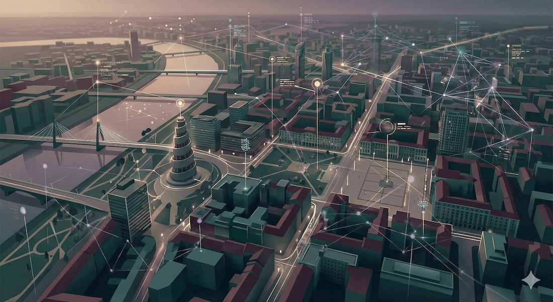
3. Digital maps and AI give rise to the "sixth element"
However, as time passed, the explosive spread of ICT technology since the launch of Google Maps in 2005 has completely overturned our understanding of space. In Lynch's time, places that had never been visited were treated as "blank areas" in the brain, and people had to construct information on their own while they were there. However, today's digital maps function in the palm of our hands as meticulous "miniature" reproductions of even the most remote corners of the world. What advantages and disadvantages does this dramatic environmental change bring to modern urban planning?
Semantic data extraction and objective urban assessment:
In recent years, research has emerged that attempts to objectively extract and map spatial meaning from the vast amounts of review text on TripAdvisor, Google Maps, and other sites using NLP (Natural Language Processing) and LLM (Large Scale Language Models).
Lynch previously excluded this "meaning" from his analysis as being "too subjective," but by 2025 he plans to turn this "meaning" into data and identify clusters of meanings common to multiple locations."Meaning Patch"This concept has been named "Smart City Planning" and is attracting global attention as a research proposal stage for data-driven smart city development, with research being published (such as a paper by the Urban Analytics Lab at the National University of Singapore) that seeks to incorporate this as a sixth element that expands on Lynch's five elements.
Impaired spatial awareness and algorithmic distortion:
On the other hand, excessive reliance on digital devices is significantly reducing the spatial cognitive abilities that humans were born with. According to a study published in the international scientific journal Nature (Scientific Reports) and a Japanese research paper by Ishikawa et al., users who rely on GPS navigation have significantly lower "spatial memory and sketch map accuracy" for their surroundings after moving compared to those who use analog methods of reading maps independently. This poses a serious risk when it comes to evacuation behavior when communication networks are cut off, such as during a large-scale disaster.
Furthermore, it has been pointed out that quantifying "meaning" through algorithms tends to place emphasis on the opinions of "loud" groups, such as tourists who are more likely to express their opinions on social media, and that this leaves out the real feelings of people rooted in the local area and the subtle nuances regarding public safety.
4. Global Perspective: Comparison of spatial management in Japan and overseas
As the way we perceive space changes in this way, comparing urban environments in Japan with those overseas (particularly in Europe and the United States) from the perspective of imagination reveals clear numerical differences in the distinctive legal systems and social backgrounds. Here, we will focus on the dynamics of land use that form the "edges" of space and the attitude toward investment in public facilities that serve as the "nodes" of cities.
The difference between blurring the "edge" and strictly managing it
In the UK (England), approximately 9,907 "Conservation Areas" have been designated as of 2024 to preserve the historical significance and identity unique to each region (according to Historic England). Furthermore, approximately 24% of the country's land area is managed as National Parks (9.5%) and Areas of Outstanding Natural Beauty (AONB) (14.5%) with strict "Districts" and clear "Edges" that restrict development, preserving a strong imagination at the national level.
Meanwhile, in Japan, boundary management is carried out through a demarcation system (urbanization areas and urbanization control areas) based on the City Planning Act. However, according to statistics from the Ministry of Agriculture, Forestry and Fisheries, agricultural land (cultivated area), which functioned as the edge of urban suburbs, has decreased significantly from approximately 6 million hectares in 1960 to 4.397 million hectares in 2019. The main causes of this decline are believed to be conversion to residential land and the deterioration of farmland due to abandonment of farmland due to aging, and the edge separating urban and natural areas is rapidly becoming blurred, raising concerns about the progression of sprawl (disorderly urban expansion).
Investing in Public Space: An International Comparison of Libraries as a Node
Additionally, the level of capital investment in public facilities that serve as important "nodes" in a city is also an important indicator for measuring the maturity of that city's community. Although it is difficult to make a simple side-by-side comparison because statistical definitions and scope differ from country to country, comparing the operating expenditures for public libraries in major countries as a reference value reveals the investment challenges for nodes in Japan.
Per capita expenditure on public libraries in major countries (reference range)
| United States (US) |
Approximately $41.55
|
| United Kingdom (UK) |
Approximately £12.7
|
| Japan (JP) |
(relatively low level)
|
*Source and calculation basis (reference value): For the US, per capita operating expenditure is based on IMLS (FY2020). For the UK, expenditure per 1,000 people (£12,732) is converted based on CIPFA (2023/24).
*Many comparative studies have pointed out that Japan's public spending is in a relatively low range compared to other countries.
The low level of investment in nodes where people gather on a daily basis and where spontaneous communications and activities intersect is an extremely serious issue that will, in the long term, lead to a decline in the centripetal force of local communities and ultimately to a loss of civic pride among residents.
5. The cutting edge of local practice: A new "connection point" created by natural capital and disaster prevention
So how can the concept of imaginability be applied and implemented in regional cities that have outstanding natural landscapes (large landmarks and edges), but face the structural challenge of "population decline" that is unique to Japan?Here, we will consider the area around Toyako Town in Hokkaido as a model case for practice, which combines the powerful natural presence of the majestic Lake Toya and the active volcano Mount Usu with unique social challenges.
The area around Toyako Town in Hokkaido encompasses the strong edge of a caldera lake and the landmarks of Mount Usu and Mount Showa-Shinzan.
The risk of losing "nodes" due to population decline and the need to break away from tourism dependence
The greatest threat facing regional cities today is none other than population decline (particularly the decline in the working-age population and children). Population decline means the physical disappearance of the "social nodes" where residents interacted on a daily basis, which were once represented by shopping districts, schools, and local meeting places. The loss of these nodes leads to a decline in young people's social participation, weakened collaboration between industries (for example, agriculture and tourism), and the exposure of "town weaknesses," such as the insufficient distribution of local products within the town.
Furthermore, excessive reliance on the stereotypical image of the area as a tourist destination for consumption by outside travelers makes the local economy extremely vulnerable to the risks of pandemics and global economic fluctuations. What is needed here is to rebuild an intrinsic identity and meaning that the townspeople themselves can feel deeply attached to.
In this regard, an academic case study (published in MDPI) of Shibamata, Tokyo, provides important insights. The study found that visitors' "willingness to pay (WTP)" through hometown tax donations, etc., is not simply a matter of consuming the scenery, but rather,"Interaction with local residents (i.e., experiences at attractive nodes)" is a type of behavioral investment that has a positive effectIn Toyako Town, there is also a great deal of potential for preventing mere passing-through tourism and creating a virtuous cycle of attracting external funds and maintaining the community by redeveloping attractive "paths" and "nodes" where residents and tourists can interact on a daily basis, with the magnificent scenery as a backdrop.
Redefining "paths" and "edges" in disaster prevention urban development
Furthermore, in a town that is constantly faced with natural threats (disaster risks) such as the eruption of Mount Usu, imaginability goes beyond simply making the town more attractive and is directly linked to "infrastructure that protects lives." The boundaries of dangerous areas on hazard maps need to be made deeply recognized by residents as clear "edges" in their living spaces. Evacuation routes that can be intuitively understood and navigated without getting lost in an emergency need to be developed as "paths," and safe evacuation centers need to function as "nodes" that are an extension of everyday life.
It is essential to apply this perspective of disaster prevention to Lynch's concept and share local information through participatory mapping that goes beyond government-led initiatives and involves local residents' associations, chambers of commerce, etc. The process of rediscovering the city's structure with the help of local residents themselves and updating it to suit the times is itself the most powerful form of placemaking in the modern era.
Conclusion: Integrating with technology to visualize the "meaning" of the city
In response to the fundamental question of "What makes a great city?", Kevin Lynch once answered with a bold statement: "A Legible City."
It is predicted that in the near future, a few years after 2025, the approach to urban planning around the world will undergo a definite paradigm shift from "shaping physical forms" to "the complete integration of digital twins and semantic data."With the advancement of AI and natural language processing, people's emotions and historical backgrounds accumulated in the invisible layers of urban space will be analyzed and mapped in real time as a "sixth element (Meaning Patch)" that expands and strengthens Lynch's five elements.
In this day and age, where people can reach their destinations without getting lost, all they need is a smartphone, even without physical signposts or a continuous landscape. This is why urban identity itself is being questioned more sharply than ever before: "Why do people choose to stay in a certain place?" and "What are the unique memories and meanings that a city holds?"
In the future, regional cities and tourist destinations must go beyond superficial landscape regulations that restrict building forms through legal regulations. The key to true regional revitalization lies in focusing on "creating a framework of experiences (reorganizing nodes and paths)" that generate chains of people's actions and emotions and are deeply etched in their memories. In a time when physical cities and digital information are highly integrated, Lynch's "imaginability" is no longer a forgotten theory of the past, but must be reevaluated now as an extremely sharp and innovative lens for visualizing and reconstructing the soul of a city.
Related Links
- Ministry of Land, Infrastructure, Transport and Tourism Landscape and Urban Development
- United Nations Human Settlements Programme (UN-Habitat)
- Town development information site "Machiko Net"
Inquiries and requests
We help solve local issues.
Please feel free to contact us even if it is a small matter.


