〜From a car-centric society to a "city for people"〜
*This article is based on the latest research and data as of February 2026.
Think about the streetscape you walk through every day. Who is the "main character" in that space?
Is it a flesh-and-blood human being waiting for the traffic light to change, or a mass of metal occupying the road as if it owns it - a car?
In the 20th century, urban planning prioritized industrial development and efficient logistics, and prioritized smooth automobile movement. However, in the 21st century, where sustainability and quality of life (QOL) are at stake, this paradigm is reaching a dramatic turning point.
At the center of this transformation is the Danish architect and urban planner Jan Gehl, who has been advocating for over half a century."Cities for People"This concept redefines urban space not simply as infrastructure for transportation, but as a "social infrastructure" where people can stay, interact, and foster culture.
Gale makes the following insightful statement when assessing the quality of a city:
"A good city is like a good party. People stay there longer than they should because they're having fun."
This article explores the history and logic behind this human-scale urban planning, exploring how it came about and has revitalized major cities around the world, such as New York and Melbourne. It also delves deeply from multiple perspectives into the "changes in modern people's walking habits" revealed by the latest AI analysis, and the specific strategies for implementing this philosophy in Toyako Town, Hokkaido, a cold, snowy region.
1. A Quiet Rebellion Against Modernism: Jan Gehl's Origins and the "12 Quality Standards"
Copenhagen in the 1960s: Questioning urban planning without people
Let's turn the clock back to the 1960s. At the time, developed countries were experiencing rapid motorization (the popularization of automobiles) and the heyday of modernist architecture, as represented by Le Corbusier and others. The landscape of forests of skyscrapers with highways weaving through them was seen as a symbol of "progress."
However, while studying architecture in the Danish capital of Copenhagen, a young Jan Gehl began to feel a fundamental sense of discomfort during conversations with his wife, psychologist Ingrid Gehl: "Why do architects and urban planners only discuss the shapes of buildings and the width of roads, and yet are indifferent to the behavior and psychology of the 'people' who live there?"
At the time, government agencies had departments that measured vehicle traffic, but no city in the world had a department that investigated how people were enjoying conversations in plazas or how long they were resting on benches. Gehl realized that this "data vacuum" was the root cause of cities lacking people.
The Miracle of Strøget and the Establishment of the PSPL Survey
In 1962, an experimental project was proposed to turn Copenhagen's main street, Strøget, into a pedestrian-only street. Initially, there was fierce opposition from local media and citizens, with comments such as, "Danish people are not Italian. We don't have a culture of enjoying cafes outdoors in the cold," and "Businesses will go out of business."
However, Gehl and his colleagues implemented a unique method that would later be called the "Public Space Public Life (PSPL) Survey." This involved thoroughly observing and recording people's subtle behavior from an "insect's eye level" perspective, at the same height as pedestrians, rather than from a "bird's eye view" looking down from above.
History has proven the results. Freed from the noise of cars, people poured into the space, and a new culture of enjoying outdoor terraces wrapped in blankets even in winter took root. Based on this successful experience, Gehl systematized the "conditions for human comfort" and compiled them into the following "12 quality standards," which are cited by organizations such as UN-Habitat.
[Jan Gehl's 12 quality criteria (summary)]
- 1. Protection: Protection from traffic accidents, crime and unpleasant weather (wind, rain, cold).
- 2. Comfort: Comfortable to walk, stand, sit, look and talk.
- 3. Enjoyment: Human scale, quality detail and the opportunity to enjoy seasonality.
2. Global Paradigm Shift: The Impact of Times Square, New York and Data Comparison
Keeping cars out of the 'world's most famous intersection'
Gale's philosophy achieved a decisive victory in New York in the 2000s, when then-Mayor Michael Bloomberg and Transportation Commissioner Janette Sadik-Khan set out to reform Times Square, a district plagued by chronic congestion and accidents.
In February 2009, they announced plans for a "pilot program," which began in stages at the end of May. By the end of August, they had completed the pedestrianization process with a simple paint job and the installation of cheap beach chairs. The effectiveness of this experiment was assessed using indicators such as taxi speeds measured by GPS data, the number of accidents and injuries, pedestrian volume, and surveys of public satisfaction with the space.
As a result, traffic flow in the area improved rather than slowed down, pedestrian injuries dropped dramatically, and pedestrian volume and satisfaction with the space improved dramatically. Following this success, the area was designed by Snøhetta and developed into a permanent plaza by 2017.
[Comparative Data] Traditional Urban Planning vs. the Gaelic Approach
So, what are the specific differences between traditional methods and Gale's approach? The table below summarizes the key differences.
| Comparison items | Traditional (Modernism) | Jan Gehl Style (Human) |
|---|---|---|
| Design Priorities | Smooth movement of automobiles and efficient logistics. Pedestrians are treated as a "traffic obstruction." |
Human behavior, bodily sensations, and sojourn. Pedestrians and bicycles are at the top, while cars are at the bottom. |
| Defining space | "Pipes of transportation." The aim is to maximize passing and processing capacity. |
"Destination (Place)". Social infrastructure that fosters interaction. |
| Evaluation Data | Cross-sectional traffic volume, congestion length, and average speed. Depends on macro-numerical data. |
Number of people there, whether they are talking, and direction of gaze. Qualitative and quantitative observation using PSPL techniques. |
| Typical measures | Road widening, overpasses, and footbridges. Strict separation of zoning. |
Pedestrian malls, parklets, and bike paths. Mixed use. |
3. Modern Issues Revealed by AI Analysis: Accelerating Cities and the Disappearance of "Staying"
The impact of a 15% increase in walking speed and a 14% decrease in the share of people staying
In recent years, advances in AI and computer vision (image recognition technology) have transformed Gehl's analogue methods into digital ones, but the data they have uncovered has revealed serious problems facing modern cities.
A related study by the National Bureau of Economic Research (NBER) used AI to compare pedestrian data from the past 30 years in public spaces in New York, Boston, and Philadelphia, revealing some shocking facts.Average walking speed increased by 151 TP3T between 1980 and 2010, while the proportion of "lingerers" who spend their time walking at less than a certain speed, such as stopping in a space, decreased by 141 TP3T.That's why.
▼ Changes in urban pedestrian behavior over the past 30 years (image)
* Visualization of trends based on related research data from NBER etc.
What does this data tell us? It shows that the pursuit of efficiency through smartphones and digitalization has transformed urban spaces from places to be "seen" to places to simply pass through. People walk quickly, as if constantly being chased by something, and the "white space" they have, such as the chance to meet a friend on a street corner and have a quick chat, is disappearing.
That is why, in future urban planning, it will be more important than ever to not just install hard infrastructure such as benches, but also to design "activities" and "mechanisms (software)" that will make people want to stop and take a look.
4. Pros and Cons: Economic Benefits and Side Effects of Public Space Investment
Economic returns from walkable cities
The old criticism that pedestrian-oriented urban planning will stagnate the economy is now refuted by the latest data. As evidence from around the world shows, walkable urban environments bring about tangible benefits, such as:
- Increased commercial sales: According to a survey by Transport for London (TfL) and others, in areas where the walking environment has been improved, the number of vacant stores has decreased by 171 TP3T and rents have increased by 7.51 TP3T. Furthermore, it has been shown that people who walk or cycle spend 401 TP3T more per month on shopping trips than people who use cars.
- Reduced health costs: Promoting daily walking reduces the risk of lifestyle-related diseases and brings great social benefits such as reduced medical costs.
- Gentrification: When a city becomes too attractive, rents skyrocket, leading to "environmental gentrification," which drives out long-time residents and independent businesses.
- Elimination Artification: In order to prevent homeless people and others from staying for long periods of time, "uncomfortable benches" and excessive management rules have been introduced, creating a dilemma that undermines public interest.
- The last mile of logistics: Securing delivery networks in vehicle-restricted areas is becoming more complicated, and there are concerns that this will be passed on to logistics costs.
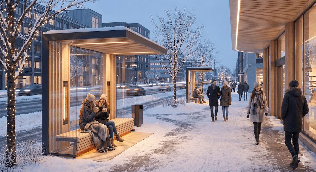
5. Implementation Strategy in Toyako Town, Hokkaido: Making Winter Your Ally
Redefining "walkability" in snowy, cold regions
So far, we have looked at examples from major cities around the world, but these examples cannot be directly applied to rural areas of Japan, especially to cold, snowy regions like Hokkaido, because the severe cold and snow in winter are the biggest enemies of spending time outdoors.
To implement a Gaelic approach in a tourist destination like Toyako, three site-specific perspectives are essential:
1. Switching to "winter activities"
The idea is to use snow as a resource, rather than simply viewing it as an obstacle to be removed. In parallel with the hard aspects of developing underground spaces and covered arcades, outdoor bonfire spots and food stalls offering hot drinks will be set up, and by combining these with the soft aspects of events to enjoy the cold, we will intentionally create a winter stay.
2. Active facades that encourage tourists to circulate throughout the area
One of the current challenges facing Toyako Onsen is that tourists tend to do all their eating, drinking and shopping inside the huge hotels, making it difficult for money to be spent on the streets of the hot spring town.
An effective solution to this problem is an "active facade" that increases the transparency of the building's first floor (facade). A design that allows the bustle inside the restaurant to be seen from the street and has terrace seating spilling out onto the sidewalk piques pedestrians' curiosity, motivating them to "go outside the hotel and take a walk."
3. Mobility rights of the elderly and demand-responsive transportation
Completely eliminating cars would deprive elderly people who cannot live without them of their means of transportation. A hybrid transportation plan based on the idea of a "compact plus network" is needed, which would involve making the center a shared space with pedestrian priority (vehicles are allowed but must drive slowly), while combining AI on-demand buses and winter-safe electric micromobility for access from the periphery.
6. Future Predictions: Towards "Adaptive Public Spaces" Using AI
From a static square to a dynamic city
Finally, we will predict how public spaces will evolve in the future.
The keyword is"Adaptive"is.
Until now, squares and parks have been static once they were built, but in the future, AI and sensors will analyze environmental data in real time, and cities will change shape like living organisms.
For example, canopies automatically deploy when strong sunlight is detected, bench placement is optimized according to the level of congestion, and lighting intensity changes at night to match the flow of people. Such "thoughtful urban spaces" are already becoming technologically possible.
It also incorporates "green infrastructure" as a measure against climate change. Removing asphalt and replacing it with highly permeable green space not only lowers urban temperatures, but also functions as disaster prevention infrastructure, improving drainage during heavy rain.
Conclusion: Eye-level perspective transforms cityscapes
The question posed to us by Jan Gehl resonates even more urgently now, half a century later.
What kind of city do we want to live in?
In the pursuit of efficiency and speed, we have lost the time to chat on street corners or look up at the sky from benches. The data shown by AI showing a "decrease in the rate of people staying overnight" may be a warning that we are slowly losing our humanity.
What is needed for future urban development is not huge, bulky buildings or impressive roads, but designs that are based on the "human experience" - how people behave and exchange smiles.
By adopting this perspective, regional cities like Toyako Town in Hokkaido have the potential to rebuild rich, unique communities that stand out from standardized urban development.
Today, when you walk around town, please stop and take a look around you from an insect's eye level. Is it an impersonal space where cars just pass by, or is it a place where you would like to stay for a long time?
This realization will surely be the first step in driving urban development for the next generation.
Related Links
- Ministry of Land, Infrastructure, Transport and Tourism: A comfortable city that makes you want to walk (walkable city)
- Gehl Architects: Making Cities for People
- NYC DOT: NYC Plaza Program
Inquiries and requests
We help solve local issues.
Please feel free to contact us even if it is a small matter.


