〜Perspectives on sustainable urban planning that Japanese regional cities facing population decline should learn.〜
*This article is based on primary sources and various research data from 2024 to 2026.
To what extent should cities continue to expand, and where does nature begin that should be protected? There is a city that has consistently provided clear answers to these fundamental questions through physical and legal "boundaries." That city is Portland, the largest city in Oregon, USA.
The "Urban Growth Boundary (UGB)" introduced by the city is, in short, a zoning method that strictly divides the inner area, where urban development is permitted, from the outer area, which is protected as nature or farmland. The primary purpose of this system is to physically prevent uncontrolled suburban expansion, or "urban sprawl." As a result, investment in public infrastructure such as water and sewage systems, roads, and schools is concentrated within the boundary, maximizing the ROI (return on investment) of the city's vast capital.
However, while this strict implementation over half a century has resulted in the preservation of a beautiful natural environment and the creation of pedestrian-friendly, compact cityscapes, it has also brought about the drastic side effects (trade-offs) of "severely soaring housing prices" and "exclusion of social minorities." The challenge of how to balance the environment and the economy now plagues urban planners not only in Portland but around the world.
This article meticulously unravels the historical evolution of UGB in Portland and the current challenges revealed by the data. Furthermore, it examines, from a strategic perspective, what we can learn from this concept of "boundaries" and how we should apply it to build sustainable ecosystems in regional Japanese cities (such as Toyako Town in Hokkaido), which face the opposite challenges of population decline and aging infrastructure.
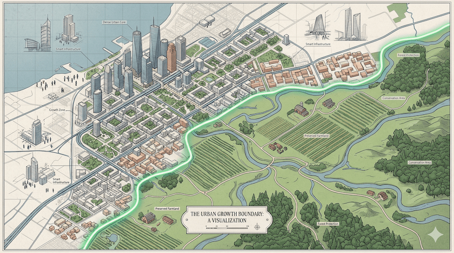
[Figure: Portland, Oregon metropolitan area. Uncontrolled development outside this area is strictly restricted.]
1. Defining the contours of cities: The birth and historical transformation of the Growth Boundary (UGB)
The origins of environmental protection and growth management in the United States
Tracing the history of growth management, the introduction of the Urban Services Boundary (USB) by Lexington, Kentucky in 1958 is cited as a precedent for broad-based growth boundaries in the United States. However, it was undoubtedly Portland, Oregon, that established it as the world's most famous and rigorous "institutionalized growth management program."
Let's turn back the clock a little. In 1973, Oregon passed Senate Bill 100 (State Land Use Act), which institutionalized urban growth management (UGBs, etc.) (signed in May 1973). This bill was groundbreaking as it legally mandated the establishment of UGBs around all cities and metropolitan areas within the state. Following this, the Portland metropolitan area's UGB was officially established in 1979 after several years of discussion and adjustments, covering a vast area of approximately 227,415 acres.
What is particularly noteworthy is that, under the Oregon system, Metro, the regional administrative body that manages the Portland metropolitan area, is obligated, based on state planning goals (Goal 14), to always ensure that "enough developable land to support future housing and economic growth for the next 20 years" is available within the boundary. In other words, the boundary is not a permanent "wall" that is drawn once and then forgotten, but a living "outline" that is rigorously reviewed by the Metro Council at least every six years based on population projections and development trend data.
In fact, since its establishment in 1979, the Portland metropolitan area boundary has been adjusted (expanded or exchanged) approximately 30 times. Large-scale expansions have also been implemented during periods of rapid population growth, with 3,207 acres added in 1998 and a record-breaking 18,867 acres added in 2002. Since then, approximately 2,100 to 2,210 acres have been added in areas such as Beaverton and Hillsboro in 2018.
More recently, in a dynamic development, approximately 494 acres of boundary lines were exchanged around Tigard in 2023. Furthermore, the Metro Council adopted the UGB expansion ordinance in Sherwood West in December 2024, and the DLCD (Department of Land Conservation and Development) published its decision in April 2025. This additional area amounts to approximately 1,291 acres and aims to secure housing and employment capacity for the next 20 years. Importantly, this expansion comes with stringent conditions, such as requiring "at least 3,120 housing units (9.2 units/net acre) in the area" and "securing and creating two industrial plots of 50 acres or more," incorporating a sophisticated design that simultaneously accommodates housing and industrial locations.
The crucial difference from Japan's "zone-drawing system"
A question might arise here: "Doesn't Japan also have a 'zoning system' for urban planning areas (distinguishing between urbanized areas and urban development control areas)?" While the concepts are indeed similar and often confused, there are crucial differences in their legal binding force, practical application, and ultimately, in how land as capital is viewed.
| Comparison element | [Portland's Growth Boundary (UGB)] | [Japanese Urban Planning: Approaches for Regional Cities] |
|---|---|---|
| Legal binding force and Difficulty of expansion |
It is extremely strict. Legally, you must prove "land supply demand for 20 years" with data, and the procedure requires state review (reviewed at least every 6 years). New development outside the boundary is virtually impossible. | The zoning system is relatively flexible. There are cases where development is permitted as an exception even in urban development control areas, so it does not completely prevent urban sprawl. There are also many areas in rural areas that are not designated as urban development zones. |
| Management entity and Wide-area cooperation |
Metro (the regional administrative body) centrally manages the boundaries of the entire Portland metropolitan area, enabling overall optimization across multiple counties. | Each prefecture and municipality is primarily responsible. However, it is difficult to coordinate development regulations across local government boundaries, which can lead to development competition among neighboring municipalities for the purpose of generating tax revenue. |
| Impact on land prices mechanism |
Because the very existence of a boundary line directly determines whether or not "development rights" exist, extreme artificial discrepancies in land values are likely to occur even on adjacent properties separated by a road. | While differences arise due to designated land use zones, the situation largely depends on infrastructure development and market forces, making it unlikely for extreme fault lines to form along boundary lines. |
| Infrastructure costs Approach to |
This strategy aims to "prevent" the increase in infrastructure costs associated with growth by physically limiting the area that can be developed, thereby forcibly shortening the distance required for new construction of water and sewage systems and roads. | With the declining population, maintaining and managing the dispersed infrastructure is reaching its limits. Currently, the focus is on gradually maintaining services and encouraging residential development through reactive measures such as "location optimization plans" and "regional public transportation plans." |
2. Light and Shadow: The Social Impact of Enforced Land Use Control
UGB (Unified Groundbreaking), which involves strong government intervention in the limited capital of land, offers clear benefits such as environmental protection and improved infrastructure efficiency. However, it also comes with serious side effects (disadvantages) due to its distortion of economic market principles. This article presents a quantitative analysis based on facts from both proponents and opponents of UGB.
① Dramatic reduction in infrastructure investment and maintenance costs:
By limiting development areas to within the boundaries, the need to haphazardly expand public services such as road networks, water and sewage systems, public transportation, schools, and police and fire services into the suburbs is eliminated. As a result, the financial burden on local governments and infrastructure maintenance costs are significantly reduced. Compact development is a rational approach that maximizes the ROI of resources invested in administrative services and also results in long-term cost savings for taxpayers.
② Protection of agricultural land and forests, and ensuring the preservation of open spaces:
Blocking urban expansion through strong zoning ensures the protection of rich natural environments and agricultural land extending beyond the boundaries. Studies in Oregon and Washington have demonstrated that growth management policies such as UGBs have a statistically significant effect over a 30-year period on forest and agricultural land conservation by curbing low-density housing development.
③ Promoting urban center redevelopment and efficient land use:
Because development on new vacant lots (greenfields) is strictly restricted, the redevelopment of underutilized land within the city (infill development) and densification are inevitably promoted. In fact, according to academic estimates, Portland's urban population increased by 541 TP3T between 1980 and 2000, but the urbanized land area increased by only 361 TP3T. This has resulted in the formation of a pedestrian- and public transport-friendly, sustainable community.
① Severe surge in housing prices and collapse of affordability:
Because the supply of developable land is artificially limited, a constant shortage of supply relative to demand leads to a sharp rise in housing prices and rents. According to research from Columbia University and others (see NAHB data), the median housing price in Portland rose by 69.411 TP3T (from 85,000 TP4T to 144,000 TP4T) between 1991 and 1996. Combined with recent macroeconomic factors, it is now extremely difficult for anyone other than dual-income households to purchase a home.
② Extreme land price disparities and exclusion of social minorities:
Despite being nearly adjacent, the land values of properties inside (development permitted) and outside (development prohibited) the boundary line result in extreme disparities. This price surge is driving gentrification, and according to the Portland Housing Bureau (PHB) 2024 report, only one neighborhood in "122nd Division" will be available for under $1 TP4T400,000, creating a critical situation where housing options are extremely limited.
③ Depletion of development land and decreased housing supply flexibility:
According to estimates by think tanks at the time, the vacancy rate within UGB plummeted from approximately 401 TP3T in 1980 to 19.81 TP3T in 1997. As a result, private compilations based on data from Census and HUD SOCDS predict that the number of new housing construction permits in Portland City in 2025 will be 648 units (a decrease of 211 TP3T from the previous year), and in the entire metropolitan area, it will be 1,752 units (a decrease of 351 TP3T), leading to market rigidity that prevents a rapid response to changing demand.
Deciphering with Data: Economic Fault Lines Created by Boundaries
To gain a clearer understanding of the economic impact of UGBs, let's visualize specific data points. The graph below clearly shows the "fault lines" in land prices occurring both inside and outside the boundary, as well as the recent stagnation in housing development.
Figure 1: Estimated difference in land valuation (per acre) inside and outside the UGB boundary.
*This estimate is based on a private analysis using 2010 tax assessment data from Washington County. It shows how artificial policies can dramatically distort the capital value of land, even when separated by just one road.
Figure 2: Trends and forecasts for the number of new housing construction permits in the Portland metropolitan area.
*This is a privately compiled summary based on data from Census/HUD SOCDS, etc. The depletion of developable land and macroeconomic factors (high interest rates, etc.) have highlighted the situation, which is far from the state's target of supplying 36,000 housing units per year.
3. Portland at a turning point: Deregulation and a shift towards hybridization
The fate of the "absolute boundary" that has reached its limit
As the aforementioned data shows, the UGB system is at a historic turning point in Portland and throughout Oregon. Due to the severe housing shortage and tight rental market in recent years (according to the PHB report, the average desired rent in 2024 will rise by 3.31 TP3T year-on-year, and the vacancy rate will rise by 8.81 TP3T), residents are leaving the area, unable to bear the high tax burden and cost of living. Since the pandemic, the area has faced a "net outflow" that exceeds natural increase.
To overcome this crisis, Oregon was forced to adopt a hybrid approach that would "maintain the basic framework of the UGB (protection of farmland and forests) while maximizing internal density and simultaneously lowering the hurdles for exceptional boundary expansions."
Specifically, the government is working to increase internal density by enacting legislation (such as HB 2001) that allows for the construction of middle housing such as duplexes and townhouses in existing single-family housing areas. Furthermore, a decisive change is the introduction of the special law "SB 1537." This system allows for the expedited process of expanding UGBs, which normally takes many years, when the purpose is to develop specific infrastructure or construct affordable housing. In short, the "absolute boundary" that was once upheld as an ideal is clearly transforming into a "flexible boundary" that is in line with the urgent demands of the real economy.
4. Application to regional cities in Japan: "Management of contraction" as seen in Toyako Town, Hokkaido
A major shift in policy objectives: From "containing expansion" to "managing withdrawal."
As we have seen, Portland's UGB has functioned as a growth management tool, focusing on "how to curb sprawl that accompanies population growth and economic growth." However, when this mechanism is applied to Japan, particularly to regional cities in Hokkaido where population decline is significant, its policy objective fundamentally changes from "restraining expansion" to "managing contraction (managing retreat)."
Let's examine a specific, region-specific issue using Toyako Town in Hokkaido as an example.
[Figure: Toyako Town, Hokkaido. While possessing abundant natural resources and a vast area, maintaining infrastructure efficiently remains a challenge.]
According to census data, the total population of Toyako Town has been steadily declining (8,416 people as of 2020), and the aging rate has already reached approximately 441 TP3T. In stark contrast to the "infrastructure shortage due to growth" faced by Portland, the biggest bottleneck in Toyako Town is the "persistent high cost of maintaining infrastructure due to low-density, dispersed housing."
With the tax base shrinking due to population decline, it is urgent to extend the lifespan of aging public facilities and infrastructure networks, implement preventive maintenance, and consider "appropriate placement" and "reorganization of regional transportation networks," rather than maintaining them haphazardly throughout the entire region.
The invisible boundary for "smart shrinking"
The approach taken by Toyako Town to maintain essential infrastructure, such as its "Regional Public Transportation Plan," is not a legal land-use regulation (UGB) like in Portland, but it can be seen as an attempt to explore de facto "boundaries (coverage areas) for daily mobility and service provision." The following quantitative facts are noteworthy here.
[The reality of infrastructure coverage]
According to our own calculations using the current state of the regional public transportation network and various basic data (※estimates based on mesh population apportionment targeting areas within a straight-line distance of 800m from living facilities), out of a total population of 8,416 as of 2020, approximately 4,294 people reside within the coverage area.Coverage is approximately 50.91 TP3TIt is suggested that it will remain at that level.
These estimates suggest that approximately half of the town's residents live in suburban areas with relatively inconvenient access to essential services. This indicates that the costs of maintaining administrative services, such as water and sewage systems, road maintenance, snow removal in winter, garbage collection, and community bus services, are structurally prone to inefficiency across a vast area.
On the other hand, according to official statistics, the town has a strong industrial base with agricultural output of approximately 5.64 billion yen (2.32 billion yen from crop farming and 3.32 billion yen from livestock farming, estimated for 2023) and manufactured goods shipments of approximately 7.99 billion yen (actual figures for 2021), and also possesses world-class tourism resources. In terms of protecting these green spaces and beautiful landscapes suitable for production from uncontrolled development of solar panels and haphazard residential development, and maintaining the region's brand value (capital), the formulation of future land-use guidelines will bring similar benefits to Portland.
If local cities can strategically define "residence and service provision boundaries" linked to their public transportation networks, and increase this infrastructure coverage rate to 70% or 80% in the future (by strongly promoting residential development), they can dramatically reduce the per capita burden of infrastructure maintenance. In the context of regional revitalization and community development, this kind of rigorous overall optimization based on "spatial ROI calculation" is essential, rather than mere emotional arguments.
Conclusion: Draw the outline of the "lifeboat" necessary to maintain urban functions.
Former British Prime Minister Winston Churchill once said,"We shape our buildings; thereafter they shape us."He left behind these words. This applies not only to individual buildings, but also to macro-level structures such as "boundaries" in urban planning.
The historical fact that Portland's UGB has demonstrated over the past half-century is that while land-use regulations achieve their initial objectives of "environmental preservation and maximizing infrastructure efficiency" to a high degree, they simultaneously bring about intense economic and social side effects such as "soaring housing prices, land monopolization, and the exclusion of minorities." UGB is not a magic wand that solves all urban problems; it is nothing more than a potent medicine that forces citizens to make a tough trade-off between "absolute protection of the natural environment" and "economic comfort in their living environment."
Turning to Japanese readers, especially those in rural areas experiencing population decline, what is the most important perspective they should learn from this case? It is to rethink the tool of boundaries not as "walls to curb urban expansion," but as "the outlines of lifeboats to maintain urban functions."
In areas like Toyako Town, where the population continues to decline and optimizing the coverage of urban functions is an urgent necessity, a social consensus is needed to draw a ruthless but essential boundary (a line of withdrawal) somewhere—a line that signifies that "we can no longer maintain administrative services and infrastructure indefinitely"—in order to envision a sustainable future that is a win-win for the surrounding ecosystem. Learning from the affordability crisis facing Portland, we must deepen the discussion on a "boundary for smart shrinking" that is appropriate for Japan in this era of contraction. This is the most important task for maximizing the ROI of invested resources and passing on capital to the next generation.
Related Links
- Metro (Portland Metropolitan Government): Urban Growth Boundary
- Ministry of Land, Infrastructure, Transport and Tourism: Overview of the Urban Planning System
Inquiries and requests
We help solve local issues.
Please feel free to contact us even if it is a small matter.


