〜The fundamental question of "Who owns the roads?" in cities〜
*This article is based on research information as of February 2026.
Who did the road originally belong to?
This simple question, which shakes the very foundations of modern cities, has been troubling urban planners around the world ever since the explosive spread of automobiles began 100 years ago.
In the past, roads were innocent playgrounds for children, places for neighborhood residents to chat, and stages for business. However, the arrival of the "Motor Age" in the early 20th century completely changed that landscape. Roads transformed from "places where people lived" to "transportation pipelines for high-speed automobiles," and pedestrians were pushed to the edges of roads, or onto underground streets or footbridges.
This revolutionary urban design concept was devised to resist this trend and "protect our lives from cars."Radburn Planis.
Interestingly, this century-old classic theory is now making a vivid comeback in modern urban planning, which aims to decarbonize and improve quality of life (QOL), particularly in the form of Barcelona's "Superblocks" concept. Why Radburn now? And what implications does it offer for regional cities in Japan, particularly those in cold, snowy regions like Toyako Town in Hokkaido?
In this article, we will explore the historical lineage of the Radburn Project in detail, and thoroughly consider, based on facts and data, its impact on new town development in Japan and the possibility of "pedestrian and vehicle separation" in the next generation.
1. What is the Radburn Project? A response to the automobile society
A house with a car entrance and a garden entrance
The origins of the Radburn Project date back to 1928 in New Jersey, USA. Architects Clarence Stein and Henry Wright proposed a solution to the situation at the time when the Model T Ford was becoming popular and traffic accidents in residential areas were becoming a social problem.
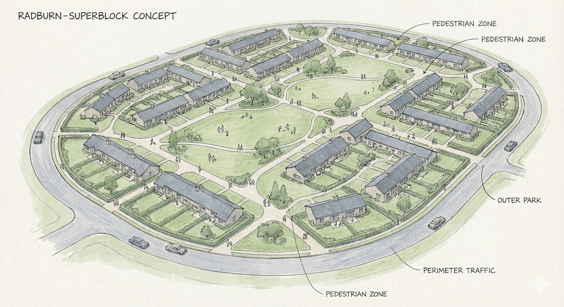
The essence of the Radburn system they proposed was:"Comprehensive separation of pedestrians and vehicles to maintain livability"Specifically, it consists of the following four elements:
-
Superblock:
The traditional small grid-like blocks were abolished and replaced with huge blocks (12-20 hectares) surrounded by arterial roads, completely eliminating through traffic within the blocks. -
Cul-de-sac:
The road for cars is a dead end (cul-de-sac) and is limited to providing access to each dwelling unit, making it physically impossible to pass through. -
Separation:
The house has two facades: a rear entrance facing the roadway and a front entrance facing the park. Pedestrians can move between the two buildings only on the footpath, without using the roadway. -
Park System:
A large shared green space is located in the center of the superblock, and the layout plan allows all homes to be directly connected to the park.
In other words, the Radburn Plan allows children to travel safely from home to school, parks, and swimming pools along greenways without ever crossing the road. This was not just a road design technique, but a highly socially reformist urban idea that prioritized "building community" and "child safety."
The differences between the Radburn system and conventional road configurations can be summarized as follows:
| Comparison items | Radburn method | Traditional Grid |
|---|---|---|
| Road connectivity | Low (dead end, no through access) | Tall (can move in any direction) |
| Traffic accident risk | Extremely low (zero through traffic) | High (many head-on collisions) |
| Pedestrian environment | Stroll along the private greenway | Moving along the side of the road (sidewalk) |
| Crime prevention | There are issues with blind spots | "Eyes on the Street" Surveillance |
*The table can be scrolled horizontally.
The Radburn neighborhood in Fair Lawn, New Jersey, USA. Irregular cul-de-sacs and green spaces can be seen.
2. Historical Changes: The Light and Shadow of the Ideal City
From an unfinished dream to Japan's new towns
Although the Radburn Project began with noble ideals, the road to realization was not always smooth. Due to the stock market crash of 1929 and the subsequent Great Depression, Radburn was unable to realize all of his original ideas, and only about a quarter of the entire design was completed.
The original plan was for the development to cover approximately 1,200 acres, but only about 149 acres were actually built. The housing supply included only 469 detached homes, 48 townhouses, 30 duplexes, and 93 apartment buildings (all figures based on data from the International Garden Cities Institute and other sources).
However, despite its commercial setbacks, its design philosophy was systematized by prominent urban theorists such as Lewis Mumford and spread overseas. The Radburn System was adopted as the "standard solution" for new town policies in Britain after World War II, and above all for large-scale housing developments in Japan during the period of rapid economic growth.
Representative examples are Senri New Town in Osaka Prefecture and Tama New Town in Tokyo, both of which opened in 1962. However, unlike Radburn's original plan (flat separation), Japan's examples have evolved into a unique "three-dimensional separation of pedestrians and vehicles" using pedestrian decks and bridges. This functioned as a vital breakwater to protect children's lives in Japan at the time, which was called the "traffic war."
Emerging issues and "New Urbanism"
On the other hand, since the 1980s, the Radburn method has also come under criticism, with the following two main points being raised:
It has been pointed out that in UK public housing estates, pedestrian-only paths behind buildings that are not visible from the roadway can become blind spots in terms of crime prevention. This has highlighted the structural risk that the "eyes on the street" concept proposed by Jane Jacobs, that is, natural surveillance through the gaze of passersby and drivers, is difficult to function.
The complex cul-de-sacs and superblocks tend to act like a maze to visitors, and some urban critics have pointed out the paradox that pedestrians are often forced to take detours compared to grid-like roads that allow them to travel in a straight line to their destination, resulting in a city that is inconvenient without a car.
3. Modern Update: Barcelona "Superblocks"
Radburn's ideas were criticized at the end of the 20th century, but in the 21st century they have made a dramatic comeback in the new context of climate change countermeasures."Superilles"It's a project.
While the former Radburn method was used to regenerate low-density suburban residential areas, modern superblocks are being applied as a method to revitalize high-density established urban areas.
The magic of "3x3" and the elimination of through traffic
Superblocks are a method of redefining nine (3x3) city blocks as a single unit and concentrating through traffic on the periphery. The important thing is that they do not "completely eliminate cars."
On internal roads, the speed limit will be kept to around 10km/h, giving priority to pedestrians and cyclists, while still allowing access for residents and those handling goods. The core of the operational design is to ensure access to the building, but not to allow people to pass through the blocks (entering and exiting via a loop).
As a result, intersections that were once covered with asphalt have been transformed into "public squares" with benches and playground equipment. This has reduced noise and air pollution, and alleviated the heat island effect. The "safety philosophy" of 100 years ago has now become "environmental and health philosophy," and is fundamentally rewriting the operating system of cities.
▼Superblock experimental area in the Poblenou district of Barcelona.
4. Data comparison and spatial analysis
Here, we will compare and analyze the original Radburn system, the general urban structure of Japan, and the latest Barcelona system from a quantitative perspective. The table below shows how each design philosophy affects urban functions.
| Comparison items | ① Radburn method (USA, suburbs) |
② Traditional grid (Japan, existing city) |
3) Barcelona Method (Modern city center) |
|---|---|---|---|
| Road connectivity (Connectivity) |
low Dead end/no passing through |
expensive Can move in any direction |
moderate Pedestrians are free, but passing is restricted |
| Traffic accident risk (Safety) |
Extremely low Zero through traffic |
expensive Frequent head-on collisions |
low Reduced by slowing down (10km/h) |
| Pedestrian environment (Walkability) |
Stroll along the private greenway A space where you don't have to worry about cars |
Side of the road (sidewalk) Noise and exhaust fumes |
The entire road is a pedestrian space The concept of "share" |
| Main Objective (Purpose) |
Ensuring child safety Realization of the Garden City |
Improving vehicle traffic efficiency Maximizing land use |
Environmental improvement and decarbonization Reclaiming public space |
*The table can be scrolled horizontally.
[Reference analysis] Image of road space redistribution
We visualized the paradigm shift in spatial usage in a typical city and a city that has introduced superblocks.
▼ Traditional urban model (car-centric)
▼ Superblock model (people-centered)
The graph can be scrolled horizontally.
*This diagram is a conceptual diagram. The Barcelona discussions have highlighted the problem that while car travel is only a part of the whole, it takes up a large amount of road space (for example, 20% of travel takes up 60% of space), and have suggested that the majority of the space occupied by through traffic should be reallocated to civic space.
5. Possible expansion in Toyako Town, Hokkaido
"Winter Radburn" wall in snowy, cold regions
So, what challenges would arise if this theory were to be applied to modern-day Japan, especially to a cold, snowy region like Toyako Town in Hokkaido? The biggest obstacle, needless to say, is snow.
The cul-de-sac, a defining feature of the Radburn system, is a structure that can become a bottleneck in snow removal operations. On a normal straight road, a snow plow can pass through by pushing the snow aside, but on a cul-de-sac, the snowplow must repeatedly reverse direction and maneuver around the dead end. Furthermore, a space (snow dump) must be secured at the back of the cul-de-sac to deposit the collected snow.
In fact, in residential areas of Hokkaido, dead-end roads are often cited as a problem due to increased snow removal costs and the risk of vehicles getting stuck during heavy snowfall. Therefore, the introduction of a pure Radburn system in residential areas should be discussed in conjunction with infrastructure investments such as road heating and underground snow melting tanks, as well as a thorough snow removal plan.
Tourist Superblocks: Redefining Hot Spring Towns
However, when we shift our perspective from a "settled residential area" to an "interactive tourist destination," Radburn and the idea of superblocks shed new light on Toyako Town.
Specifically, the plan is to introduce "tourist-oriented superblocks" in the central city area of Toyako Onsen. Currently, the lakeside promenade is beautifully maintained, but the main street on the mountain side of the hotel complex still prioritizes cars, including through traffic. In this area, approximately 3x3 city blocks will be treated as a single unit, and the interior will be converted into a zone for pedestrians and emergency vehicles only (10km/h or less).
▼ The downtown area of Toyako Onsen. The grid-like road network has the potential to be developed into superblocks.
This measure is expected to create the following virtuous cycle:
- Increased mobility and economic impact:
By becoming a "walkable city," tourists will definitely leave their hotels more often and visit restaurants and souvenir shops around town. - Rebranding the value of your stay:
A tranquil space free from the noise and exhaust fumes of cars enhances the resort's status. In particular, during the snowy season, being able to stroll through the snowy scenery without worrying about cars is a highly valued experience for inbound tourists.
Furthermore, in the future, low-speed mobility vehicles (green slow mobility) utilizing autonomous driving technology will circulate within the block, connecting the "last mile" from the parking lot to the hotel and each store. This could be said to be the image of a modern version of Radburn, a "hybrid superblock" that combines technology.
Conclusion: Putting people back in the center of cities
The Radburn Project is not just something that appears in history textbooks as an "unfinished dream" from 1929. It poses a sharp question for modern society: which should take priority: "efficiency (speed)" or "humanity (wealth)?"
Would you rather have the convenience of being able to park your car right in front of your house, or have your children run around safely right in front of your house?
Now, as we face new challenges such as climate change and population decline, Radburn's ideas once again present a solution in the form of the "superblock." Areas with beautiful scenic resources like Toyako Town have the potential to break away from traditional road planning and realize Radburn's vision of a "marriage of rural and urban" using modern technology, demonstrating a next-generation tourism and residential model to the world.
What we should choose are not roads for cars, but roads that are "places" where people's smiles come and go.
Related Links
- Ministry of Land, Infrastructure, Transport and Tourism: Pedestrian Accessibility Improvement Road System (Hokomichi)
- Urban Renaissance Agency: Senri New Town urban development
- Barcelona City: Superblocks (Superilles) Project Official Website
Inquiries and requests
We help solve local issues.
Please feel free to contact us even if it is a small matter.


