〜The Possibilities of the "Neo-Roman Model" as a Sustainable Urban Model in a Shrinking Society〜
*This article is based on the Hokkaido Prefectural Government's road status survey (2023) and knowledge of ancient Roman history and disaster prevention engineering.
"A city is not a collection of stones and bricks, but the will of the people who live there."
These words, left behind by St. Augustine, were intended to explain the spirituality of cities, but in reality, what physically supports cities is the cold, hard-nosed engineering reality of their "infrastructure." And once the earth bares its fangs, no matter how strong the people's will, the fragile infrastructure will instantly collapse and the city's functions will be paralyzed.
The ancient Roman Empire is often spoken of in terms of its military conquests and political drama, but its true nature, which should be reevaluated from a modern urban engineering perspective, is its aspect as an "infrastructure state" constructed with astonishing scale and precision. They did not simply occupy territory; they physically imprinted the "Roman Order (Ordo)" there by embedding systems for supplying water, treating wastewater, and transporting goods. It is particularly noteworthy that in the Italian peninsula, which was prone to volcanic risks such as the tragedy of Pompeii, they aimed for infrastructure that would not break (or would be easy to repair).
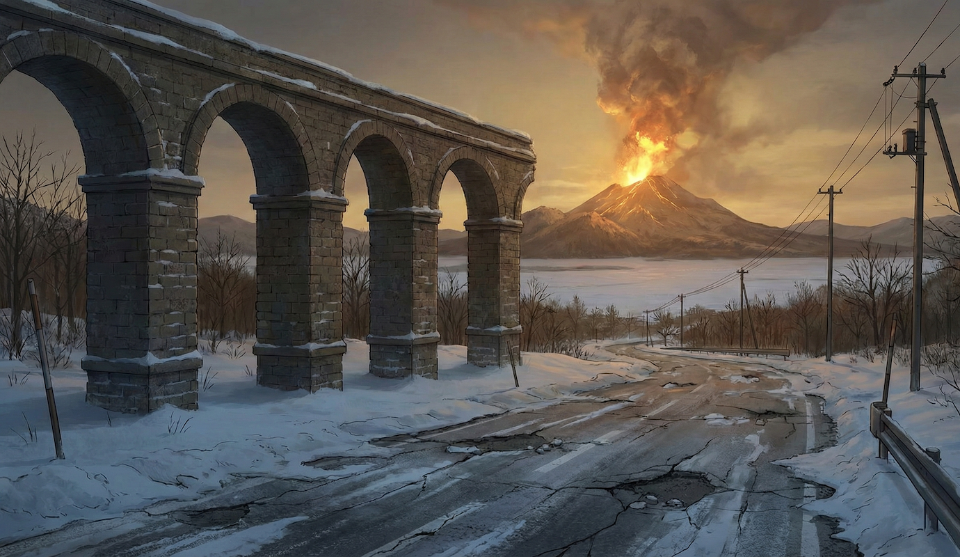
Now, let's turn our attention to modern Japan. Hokkaido, which has seen rapid infrastructure expansion since the Meiji era, clearing virgin forests, is now at a critical historical crossroads. With a declining population and aging infrastructure, it is no longer possible to maintain the "endless expansion" of the past. Furthermore, Toyako Town is being asked to decide whether to live with the "pulsation of the earth" posed by Mount Usu, which erupts every 20 to 30 years.
This paper provides a thorough comparative analysis of the Roman engineering heritage that continues to function for over 2,000 years, the current state of Toyako Town in Hokkaido, and the unavoidable risk of crustal movement. What emerges from this analysis is the outline of a new "urban engineering" to maintain affluence and safety in a shrinking society.
1. The Engineering Foundations of Roman Urban Planning: The Pros and Cons of Castrum and the Grid
The logic of "Castrum" that imprints order
Roman urban planning was born out of a highly practical military discipline rather than aesthetic imperatives, and its origins lie in the "castrum," the camps that Roman legions set up during their campaigns.
In an unknown and hostile environment, they began by aligning two major roads, the Cardo Maximus (north-south axis) and the Decumanus Maximus (east-west axis), at right angles to each other. This intersection (groma) was considered the navel of the city, and the Forum (forum), which served as the administrative, economic, and religious center, was established there.
This strict Cartesian grid system was not merely a method of zoning. It functioned as a device of "standardization," ensuring that Roman citizens enjoyed the same sense of space and convenience throughout the empire. However, more importantly, this grid was a military infrastructure that enabled the "rapid deployment of troops," which in modern terms is synonymous with ensuring "rapid evacuation and rescue routes" in the event of a disaster.
Grid Transplantation in Hokkaido and the Environmental and Disaster Paradox
Meanwhile, this Roman way of thinking was also strongly reflected in the development of Hokkaido in the 19th century. The grid layout seen in Sapporo and other major cities in Hokkaido was the introduction of an "American-style grid" based on advice from Horace Capron, an American advisor invited by the Meiji government. However, just like Rome, its essence was an act of forcibly overwriting the "chaos" of virgin forest with a governable "order."
However, a system that worked in the Mediterranean world is not entirely suited to the northern climate, especially the environment around Lake Toya, where volcanoes and snow coexist. See the comparison table below.
| Comparison items | [Ancient Roman Empire] (Mediterranean climate and seismic zone) | [Modern Hokkaido, Lake Toya] (Subarctic humid zone/active volcanic zone) |
|---|---|---|
| The main purpose of the grid | Visibility of military discipline and governance and rapid deployment of troops | Land commercialization (real estate division) and efficient settlement |
| Climate and disaster adaptation | Straight roads allow air to pass through, releasing heat from the city (cooling effect) | Straight roads become a path for strong winds, triggering ground blizzards / Securing evacuation routes in the event of an eruption |
| Infrastructure redundancy | Backup system with multiple aqueducts (risk diversification) | Dependence on a single lifeline: High risk of disruption in the event of a disaster |
Of particular note is its ability to respond to crustal movements. In the 2000 eruption of Mount Usu, National Route 230 was destroyed in a stepped pattern by ground uplift. The Roman grid is effective for areal control, but when the terrain itself changes shape, its rigid grid structure could actually hinder recovery. Just as a straight road intended to bring about coolness can become a wind corridor for fierce blizzards in Hokkaido, the variables of climate and geology are essential when transplanting technology.
2. Infrastructure durability and economy: gravity vs. electricity vs. variable forces
Roman roads: multi-layered structures built to last 1,000 years
Compared to modern road engineering, the unique feature of Roman roads (Viae Romanae) is their overwhelming "excess quality." While modern asphalt pavement is about 20-30cm thick, including the surface and base layers, it was not uncommon for Roman main roads to be over one meter thick.
They dug deep into the ground and laid a layer of large stones called "Statumen" at the bottom, followed by a layer of clay and gravel called "Rudus," then even finer crushed stone called "Nucleus," and finally a layer of flat, polygonal paving stones called "Summa Crusta" on top, all of which fit together tightly together to create a sturdy four-layer structure (Agger).
This solid structure ensured that the road was maintenance-free in peacetime, and in the event of an emergency (military action or disaster), the roadbed itself would be able to maintain its functionality even if the surface was damaged, ensuring "resilience."
Comparison of design life and disaster resistance of road infrastructure
*Although asphalt is flexible, there is a risk that the entire roadbed will collapse in the event of a large-scale crustal movement.
Energetics of "water" and "heat" in volcanic areas
The approaches of both organizations are also highly suggestive when it comes to water infrastructure.
Roman aqueducts maintained an extremely gentle gradient of approximately 0.11 TP3T on average, and continued to transport water using only "gravitational potential" without the use of external power. This meant that the system was unaffected by power outages, meaning that water would likely continue to flow even in the event of a disaster.
In contrast, modern Japanese water systems consume enormous amounts of electricity to pressurize the water using pumps. In volcanic areas like Toyako Town, there is always the risk of power outages due to eruptions. If the power goes out, the water also goes out, so it has to be said that modern systems are more vulnerable to disasters than the Roman system.
However, Lake Toya has a powerful energy source that Rome lacks: geothermal energy (hot springs). Just as the Romans used gravity, if Toyako Town could convert the thermal energy at its feet into a passive system for snow removal (road heating) and hot water supply, it could reduce its dependence on external electricity and increase its autonomy in the event of a disaster.
3. The double whammy of infrastructure “Ponzi schemes” and geological risks
During the period of rapid economic growth, Japan continued to expand its cities to the suburbs under the premise that "building roads will lead to the development of cities and increase tax revenues." The actual length of roads (in service) in Hokkaido isApproximately 90,775km(2023), which is equivalent to a length that circles the Earth more than twice.
The structure in which the temporary cash flow generated by new development was used to cover the maintenance costs of old infrastructure was a kind of ``viable business.''
However, as the population began to decline, this cycle began to reverse. In the context of urban planning, this is called a "Ponzi scheme of growth," but in Toyako Town's case, it is even more serious.
Add to this the risk of infrastructure deterioration and periodic tectonic shifts that could cause destruction, and maintaining all of this low-density, sprawling urban space on land that "could be repaired but still be destroyed" is a financial disaster.
Correlation between population density and administrative costs: Adding risk coefficients
A study by the Ministry of Land, Infrastructure, Transport and Tourism (MLIT) shows that as population density in DIDs (Densely Inhabited Districts) decreases, administrative costs per capita rise exponentially. The figure below visualizes how sprawling cities are inefficient and disadvantaged in disaster recovery.
Image of rising costs per person due to declining population density
high density
(compact)
standard
local city
more than 3 times
Low density/diffuse
(High risk)
*Conceptual diagram of total costs for infrastructure maintenance, snow removal, disaster recovery, etc.
4. Specific Prospects for Toyako Town: Implementation of the Neo-Roman Model
So, based on these historical and quantitative analyses and the premise of a "changing earth," what kind of strategy should local governments like Toyako Town adopt? We propose a "Neo-Roman model," which reinterprets ancient Roman wisdom for a modern, volcanic region.
① Separation of risks and costs through "zoning"
Just as Roman cities clearly separated the inside and outside of their walls, modern Toyako Town also needs to clearly zone itself into "areas to be protected" and "areas to be left to nature."
- Core Zone (High Density and Durability): Areas where economic activity is concentrated and where risk is relatively easy to control, such as the center of the Abuta district (around the town hall), will be targeted for investment in "highly durable infrastructure" like Roman roads and "electric pole-free and utility tunnels," making these areas bases that can maintain their functionality even in the event of an eruption.
- Buffer Zone (low density/variable): In areas near the crater or directly above the fault line, we will adopt cheap, easily repairable infrastructure (such as boardwalks and simple pavements) that is "assumed to collapse" and limit habitation. We will have the "courage to retreat," just as Rome did when it prohibited building on floodplains.
② Public-private partnerships (euergetism) for infrastructure maintenance
In the Roman Empire, many public buildings and infrastructure were built and maintained through private donations by the emperor and wealthy citizens (Euergetes). In modern times, it is impossible to maintain and update all infrastructure through tax revenues alone.
- ● Clarification of bathing tax and accommodation tax as special purpose taxes: Rather than sinking taxes collected from tourists into general revenue sources, the tax will be made visible as a specific source of revenue for "disaster prevention, landscape maintenance, and infrastructure renewal," thereby strengthening the principle of beneficiary payment.
- ● Infrastructure tourism (Museum of Changing Earth): The remains of the 2000 eruption of Mt. Usu (such as the Konpira crater) are themselves a tourist attraction, and the destroyed infrastructure is itself a tourist resource. Just as the ruins of Rome attract people, we will create a recycling model by preserving and exhibiting "roads destroyed by the forces of nature" and returning the profits to the maintenance costs of "living roads."
- ● Corporate hometown tax donations and naming rights: The maintenance rights for specific evacuation routes and parks will be sold to companies, allowing them to participate in infrastructure maintenance as part of their BCP (business continuity plan) and CSV activities.
Conclusion: Embrace change and remain flexible
The reason why Roman aqueducts continue to fascinate people even after 2,000 years is not simply because they were pipes for transporting water, but because they blended in with the landscape and possessed architectural aesthetics that were the pride of the city.
What is necessary for future urban planning in Hokkaido and Toyako Town is to move away from "rigid engineering" that tries to completely control nature. We need a shift to "flexible infrastructure" that has the robustness of Rome at its core, but can flexibly adapt to the changing landscape.
Reconstructing "cities as infrastructure" is nothing less than building modern-day ramparts to maintain a cultured, human lifestyle amid the twin storms of population decline and volcanic activity. It is the responsibility of those of us living today to return to the basics of stacking stones and laying roads, and leave infrastructure as an "asset" rather than a "liability" to the next generation.
Related Links
- Ministry of Land, Infrastructure, Transport and Tourism: Infrastructure Maintenance Information
- Japan Society of Civil Engineers: Research on the Civil Engineering Heritage of the Roman Empire
- Toyako Town: Second Toyako Town Urban Planning Master Plan
Inquiries and requests
We help solve local issues.
Please feel free to contact us even if it is a small matter.


