〜Successes and challenges of "living heritage" after 70 years〜
*This article is based on information as of February 2026.
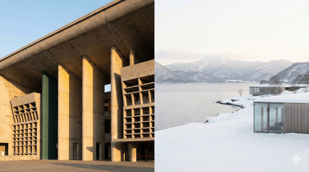
At the foot of the Himalayas, on the border of the northern Indian states of Punjab and Haryana, lies a place that architects and urban planners from all over the world dream of visiting.
The name of the city is Chandigarh.
It is the only experimental site that embodies, on a city-wide scale, the concept of the "shining city" that Le Corbusier, the master of modern architecture of the 20th century, advocated throughout his life. Contrary to the common image of Indian cities as chaotic and noisy, it is home to geometric grids, tranquil buildings made of exposed concrete, and surprisingly abundant green spaces.
But why should we, who are active in the faraway town of Toyako in Hokkaido, pay attention to this Indian city?
This is because Chandigarh is an artificial city that attempted to create an ideal out of a "tabula rasa" (empty wilderness), and its spirituality contains extremely important implications for the history of Hokkaido's development since the Meiji era, as well as the challenge of "urban development in an era of population decline" that we face today.
In this article, we will dissect the urban structure of Chandigarh, a World Heritage Site, and, while providing comparative data with Japanese planned cities such as Sapporo, we will take a deep look at the "Shrinking Smart" and "Relationship Design" that will be necessary for regional cities of the future.
1. A "City of Hope" Born from Tragedy: Historical Background
The construction of Chandigarh was not just an urban development project, but a grand reconstruction undertaking that placed the nation's prestige at stake.
1-1. Scars of Partition in 1947
Its origins date back to the historical tragedy of the partition of India and Pakistan in 1947. The ancient city of Lahore, once the capital of Punjab and a cultural and economic center since the Mughal Empire, became part of Pakistan when the border was demarcated.
This not only left the Indian state of East Punjab without administrative functions, but it also forced it to accept millions of Hindu and Sikh refugees pouring in from across the border. Amid this chaos, Jawaharlal Nehru, India's first Prime Minister, made a decision.
"This new city must not be bound by the traditions of the past. It must symbolize India's faith in its future."
— Jawaharlal Nehru (India's first Prime Minister)
What Nehru wanted was a model case for a "New India" based on democracy and scientific rationality that would overcome the problems of overcrowding and unsanitary conditions that existed in existing Indian cities.
1-2. Shift from Mayer's plan to Le Corbusier's plan
The original plan was commissioned to American urban planners Albert Mayer and Matthew Nowicki, who proposed a "Garden City" with curving roads and neighborhood blocks (superblocks) that followed the topography. However, Nowicki's sudden death in a plane crash in 1950 meant the plan was scrapped.
Le Corbusier was invited to succeed him. He formed a team with his cousin Pierre Jeanneret and the British architects Fry and Drew. While retaining Mayer's concept of "neighborhoods," he completely redesigned the city's structure. He replaced the curvilinear road network with an orthogonal grid system that maximized the efficiency of automobile traffic, transforming the city into a modernist city composed of reinforced concrete and geometric order.
2. Urban Anatomy: Human Body Analogy and the 7V System
The greatest feature of Le Corbusier's urban planning is that he viewed the city not as a machine, but as an organic "living organism."
2-1. The Biological Analogy
The layout of Chandigarh on the map is likened to each part of the human body as shown below.
-
The Head: Capitol Complex (Sector 1)
It is located at the northern end of the city, at the highest point with the Siwalik Hills in the background. The State Assembly Building (legislative), the High Court (judicial), and the Combined Government Building (administrative) are all concentrated here, and it is the city's intelligence and chain of command. In 2016, the architectural works of Le Corbusier, including this area, were registered as a World Heritage Site. -
The Heart: City Center (Sector 17)
Located at the physical center of the city, it is a hub of activity that brings together commercial facilities, offices, the central library, and the bus terminal. The vast pedestrian-only plaza circulates the energy of people throughout the city, like a pump that sends blood throughout the body. -
The Lungs: Leisure Valley
This vast green belt runs north to south through the city. It is home to Rajendra Park and the Rose Garden, and continues to supply fresh oxygen to the living organism that is Chandigarh. This overwhelming green coverage is an important factor in supporting the environmental quality of Chandigarh.
2-2. The "7V" road hierarchy that transports blood
Corbusier, who foresaw the arrival of motorization, strictly separated roads according to purpose of use and speed, a system known as "7V (Les Sept Voies)."
| name | Function and purpose | Features and Evaluation |
|---|---|---|
| V1 | Inter-city highways | Arteries that connect to the outside world |
| V2 | Urban arterials connecting major public facilities and sectors | Commonly known as "Madhya Marg", it functions as a commercial and business hub |
| V3 | Highway surrounding the sector | It forms the boundary of the sector and is designed to prioritize high-speed travel, preventing through traffic from entering residential areas. |
| V4 | Shopping street road in the sector (irregular curves) | The main street of daily life. Shopping is possible while driving at low speed. |
| V5-V6 | Circulation roads within the residential area and access roads to each house | An alley that maintains a quiet living environment |
| V7 | Pedestrian-only road through the green belt | Ideal for "pedestrian and vehicle separation." Safe access to schools and parks. |
*Please scroll the table horizontally to view.
*V8 was later added as a bicycle-only path.
3. Comparative Analysis: Sapporo's "Open Grid" and Chandigarh's "Closed Sector"
Sapporo, Hokkaido, a city familiar to many of us, is also a grid city that was planned during the Meiji period. However, its design philosophy and urban behavior are fundamentally different from Chandigarh.
Understanding this difference is extremely important when considering the balance between "openness" and "closedness" in future urban development.
| Comparison items | Sapporo | Chandigarh |
|---|---|---|
| City character | Development base/commercial city | Administrative capital and symbolic city of modernism |
| Basic Unit | City block (approx. 109m x 109m) A small grid of 60 square meters |
Sector (approximately 800m x 1200m) Giant blocks aimed at self-sufficiency |
| Structural features | Open Grid Accessible from anywhere, the building faces the road and is surrounded by a constant stream of activity. |
Closed Sector The perimeter is blocked off by walls and greenery, and the building faces inwards to exclude through traffic. |
| Metabolism (updateability) |
expensive The plots are small, making it easy to rebuild buildings or change their use. |
Low (rigid) Large planning units and strict regulations make partial renewal difficult. |
| population density | Approximately 1,750 people/km² | Approximately 9,252 people/km² (2011 census) |
*Please scroll the table horizontally to view.
Sapporo's grid is dense and has an "open" structure that allows anyone to move freely, which has allowed the city to repeatedly renew itself in line with the times.
Meanwhile, Chandigarh's "sector" is enormous, approximately 80 times the size of a Sapporo city block. By surrounding it with a highway (V3) and physically blocking through traffic, a tranquil living environment has been created within the sector. This can be described as an "introverted" city.
Chandigarh, which ensures tranquility and safety, and Sapporo, which tolerates bustle and change. It is not a question of which is superior, but rather the difference in the "will" for which the city was designed that has determined the "personality" of the city over the course of more than 70 years.
4. Review after 70 years: Contrast of successes and challenges
More than 70 years have passed since its construction, and Chandigarh has now grown into a complex city that combines both successes and failures. We will examine its current state with data.
4-1. Unexpected population explosion and sprawl
The initial planned population was estimated at 500,000 (150,000 in the first phase, 350,000 in the second phase). However, due to the concentration of administrative functions and economic development, the population has rapidly increased far beyond this estimate.
Chandigarh population trends (administrative districts)
Source: Census of India and recent urban trend estimates
*Since there is no official census data from 2011 onwards, this is an estimate.
*Please scroll the graph horizontally to see it.
4-2. Light and Shadow: QOL and Segregation
This rapid growth has had two effects on the city.
Compared to other Indian cities plagued by disorderly development and traffic congestion, Chandigarh maintains an orderly infrastructure and a stable power supply. Furthermore, thanks to the concentration of educational institutions, including Panjab University (Sector 14), the city boasts a literacy rate of 86.01 TP3T, significantly higher than the national average (approximately 741 TP3T). The city's brand value as a World Heritage Site also contributes to fostering civic pride among its residents.
As land prices within planned sectors soared, service workers and immigrants who support cities were forced to live in unplanned, peripheral areas. As a result, slums and disorderly satellite towns sprang up around wealthy planned cities, creating a spatial segregation of social classes that has become an issue. This has been described as one of the structural contradictions of modern urban planning.
5. Proposal for Toyako Town, Hokkaido: Strategies for "Shrinkage" and "Landscape"
So, what can Hokkaido, where the population is declining and aging, and Toyako Town, where we are based, learn from the example of Chandigarh? Rather than simply "copying the building," we need to apply its design philosophy (algorithm) to modern-day issues.
5-1. Consolidating bases into "compact sectors"
Chandigarh's sector system (approximately 800m x 1200m) was an "expansion model" during a period of population growth. However, the idea of "completing daily life functions within walking distance" is particularly applicable to a society with a declining population.
【suggestion】
The Toyako hot springs area and the main settlements (Toya and Abuta) will each be redefined as a "compact sector." Within this sector, town hall branches, clinics, shops, and elderly housing will be concentrated.
- Realizing a "walkable village" where people can live without a car
- Reduce administrative costs by prioritizing snow removal areas
- Ensuring safe movement for the elderly through pedestrian-only roads (V7 concept)
5-2. Protecting landscape assets through modern-day "Edicts"
To protect the city's dignity, Le Corbusier established the "Edict of Chandigarh," a set of powerful landscape control rules that included a ban on the erection of personal statues and restrictions on buildings that obstructed views of natural areas (lakes and mountains).
In Toyako Town, the views of Mt. Yotei and Nakajima Island, as well as the tranquility of the caldera lake, are irreplaceable "capital." Now is the time for us to formulate stronger and more specific "Landscape Formation Guidelines (a modern version of Edict)."
It's not about "what to make,""What not to build (skyscrapers, flashy signs, walls that block the view)"What is needed is a will to legally decide this and protect this aesthetic sense for 100 years to come.
5-3. Becoming a mecca for architectural tourism
Just as Chandigarh attracts people from all over the world as a "holy land of architecture," Toyako Town can also brand itself as a tourist destination with the theme of "modernism in harmony with nature."
The groundwork is already in place, with a hotel overseen by Kengo Kuma and a nearby work by Tadao Ando. Rather than simply demolishing the aging hot spring hotel, the building's skeleton will be preserved and renovated, revitalizing it as a co-working space and artist-in-residence facility. The design code, which contrasts the strength of concrete with the natural beauty of Lake Toya, will be a catalyst for attracting a new type of tourist.
Conclusion: The quality of a city is determined by its structure and will.
In the Capitol Complex in Chandigarh, a huge monument called the "Open Hand" spins in the wind.
“Open to give, Open to receive”
(Open to give, open to receive)
It is a symbol of peace and reconciliation, and also represents Corbusier's testament that cities should not be closed off to the outside world.
Urban planning is not just about laying out roads and arranging buildings. It is also about the philosophy of the people who live there and how they interact with nature and other people."Relationship design"That's it.
Hokkaido's frontier spirit and the rational spirit of modernism can be combined with modern digital technology (smart cities) to send a new definition of "prosperity" in an era of declining population to the world from here in Toyako. This is the baton we must take up from the great experimental city of Chandigarh, and is our responsibility to future generations.
Related Links
- UNESCO World Heritage Center – The Architectural Work of Le Corbusier
- Chandigarh Administration (Official Website)
- Cabinet Secretariat – Digital Garden City-State Initiative
Inquiries and requests
We help solve local issues.
Please feel free to contact us even if it is a small matter.


