〜Rethinking the 2,500-year-old Hippodamos System, an urban operating system〜
*This article is based on survey information and public data as of December 2025.
The shape of the "town" that we walk through every day without even thinking about it.
In particular, the orderly grid plans seen in Sapporo, Kyoto, and other major cities around the world have become a familiar sight in our daily lives. But when you stop to look at a map, have you ever stopped to think about the hidden intentions behind it?
"Why did the roads have to intersect at right angles?"
"Why did the blocks have to be square?"
To find the answer, we need to turn back the clock to ancient Greece in the 5th century BC. There, we find the obsession of one genius architect who sought to inscribe human reason and law into the chaotic natural world.
This paper delves into the depths of the Hippodamus Method, the most robust operating system in the history of urban planning. It then applies this historical insight to the contemporary field of Toyako Town in Hokkaido, which is currently experiencing population decline and changes in tourism, and proposes ways of developing towns in the future.
1. The Triumph of Reason: The Philosophical Origins of the Hippodamus Method
From Chaos to Cosmos
Naturally occurring settlements tend to spread irregularly along the terrain and animal trails. Winding alleys, dead ends, and irregular squares are organic and attractive, but they pose many challenges in terms of governance, defense, and fairness.
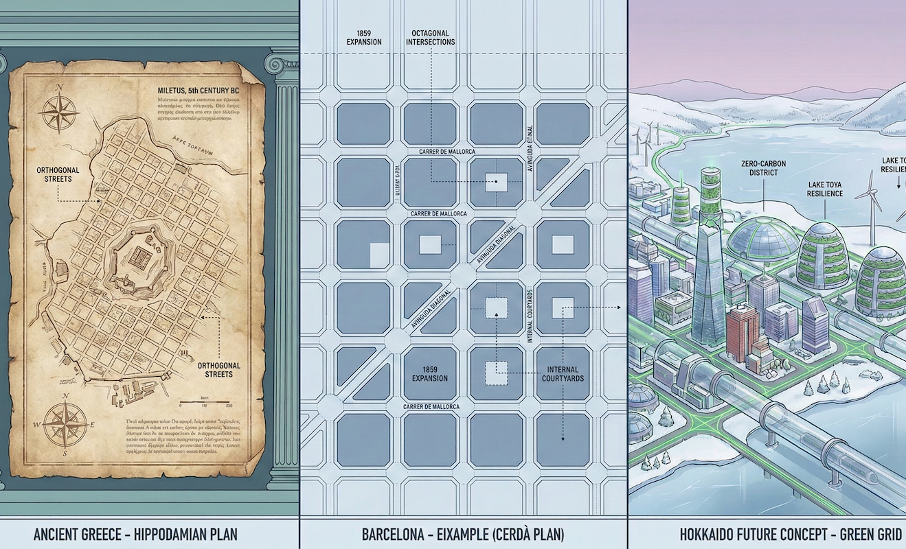
In the 5th century BC, Hippodamus of Miletus appeared and overturned this conventional wisdom. Described by Aristotle as "the first political theorist" in his Politics, Hippodamus was no mere engineer. He clearly separated the functions of cities into three areas: "sanctuaries" for religious ceremonies, "public spaces" for politics and commerce, and "private spaces" for the lives of citizens, and attempted to integrate these areas on an orthogonal grid.
In other words, for Hippodamus, the "straight line" symbolized human "reason" in the face of the vagaries of nature, and the "right angle" was the "ruler of democracy" for the fair distribution of land among citizens.
The Genealogy of Grids Covering the World
This revolutionary invention was later spread to the Hellenistic world by Alexander the Great's eastern expedition, and then throughout Europe by the Roman Empire.
The Romans, in particular, made extensive use of this system in building their military bases (castrum). Using a surveying instrument called a "groma," they defined the north-south axis (cardo) and the east-west axis (decumanus), and constructed artificial structures one after another in the wilderness. Roman grids are still embedded deep within modern-day major cities such as London, Paris, and Turin.
The following timeline graph visualizes how the grid plan has reappeared and changed over the course of history.
▼ Paradigm shift in urban planning
2. Two Grids: Barcelona for "Life" and New York for "Desire"
In modern times, cities were hit hard by a population explosion caused by the Industrial Revolution. Two cities confronted this crisis using the same "grid" method but with completely different ideas: Barcelona in Spain and New York in the United States.
Barcelona: Anatomy of a Breathing City
In 1859, Ildefonso Cerda drew up a plan for the expansion of Barcelona (the Eixample), which was based on a thorough humanist approach.
Shocked by the short average life expectancy of the working class at the time, he brought a medical approach to urban planning. He determined the width of streets based on the calculation that "the amount of air each person needs to live healthily is 6 cubic meters per hour." Even more noteworthy is his "octagonal city blocks," in which the corners of intersections are cut off at 45 degrees. This was an astonishing example of foresight, anticipating the arrival of steam automobiles, which did not yet exist at the time, in order to ensure visibility and a good turning radius at intersections.
New York: Standardization of Real Estate as a Product
On the other hand, the New York Manhattan Commission Plan of 1811 was permeated with an extremely dry "pragmatism."
The grid here was adopted not for philosophical or hygienic reasons, but as a packaging technique for efficiently buying and selling land. Right-angled land reduces the amount of dead space when constructing buildings, minimizing construction costs. The long, narrow east-west shape of Manhattan's blocks is the crystallization of cold-hearted economic rationality, allowing for maximum logistical access to the Hudson River and East River while also packing in as many lots as possible.
The comparison table below provides a detailed analysis of the differences in the design specifications of the two cities. Please pay attention to the differences in the "philosophy" behind the numbers separated by dashed lines.
| Comparison items | [Hygiene and Life] Barcelona (Cerda Plan) |
[Economy and efficiency] New York (1811 plan) |
|---|---|---|
| Basic idea | Egalitarianism/Hygiene Sunshine and air for all classes |
Capitalism/Practical Land mobility and construction cost reduction |
| Block size | 113.3m x 113.3m Near-square uniformity |
Approximately 60m x 240m A long rectangle from east to west (emphasis on ports) |
| Intersection Shape | 45 degree chamfer (octagonal) Ensuring plaza-like space and visibility |
Right angle (90 degrees) Eliminate land waste to the maximum extent possible |
| Green spaces and white space | Courtyard (patio) The interior of the block will be turned into a shared garden for residents |
Extremely small Later, we needed Central Park. |
3. Modern challenges and the "superblock" solution
Dividing cities by automobiles
The advent of motorization posed a challenge to the grid plan. The structural feature of the grid, namely the large number of intersections, increased the risk of chronic congestion caused by waiting at traffic lights and head-on collisions.
Straight roads, once symbols of fairness, became dangerous channels that drew through traffic (rat runs) deep into residential areas, bringing noise and exhaust fumes. Cities were fragmented by cars, and communities became increasingly divided. This was the reality of the late 20th century.
Superblocks (Superilles)
Once again, Barcelona broke the deadlock by rewriting the "rules of operation" rather than destroying the existing grid.
Specifically, nine 3x3 city blocks are considered as one large unit (superblock). Vehicle access within the unit is limited to residents and emergency vehicles, with passing traffic directed to the outer roads. This has dramatically transformed the asphalt within from a "road" to a "living space for citizens." Noise levels have decreased and sales in the shopping district have increased. The flexibility of the grid has made the transition to a modern environmentally friendly city possible.
4. Proposal for Toyako Town, Hokkaido: "Micro-Grid" for Tourism and Disaster Prevention
Data analysis of local issues
Now, let's shift our focus to Toyako Town in Hokkaido, Japan. Since the Meiji era, Hokkaido has been one of Japan's leading "grid advanced areas," adopting American methods. However, Toyako Town is currently facing the following structural challenges:
-
1. Population decline and sponge-like effects:
As urban areas become increasingly hollowed out, maintenance costs are rising, and compact city development is an urgent priority. -
2. Changes in tourism style:
From group travel to individual travel (FIT), and from a hotel-based stay to a city walk-style stay. -
3. Disaster risk (volcanoes):
Memories of the 2000 eruption of Mount Usu. Balancing tourism and evacuation is the top priority.
What solutions can be found to these issues by applying a modern interpretation of the Hippodamus method? Below, we propose three specific strategies.
Strategy 1: Transforming the hot spring town into a "super block"
Utilizing the current grid structure of Toyako Onsen Town, vehicle traffic will be restricted by time period or made one-way on the street (shopping street area) that runs parallel to Lakeside Street.
As the example of Barcelona shows, expanding pedestrian space increases the length of time tourists stay. By transforming a "road that is simply passed through" into a "space to stay in," it encourages people to stop by restaurants and souvenir shops, creating a circulation in the local economy. This is a low-cost, highly efficient method of urban regeneration that does not involve large-scale redevelopment.
Strategy 2: "Disaster prevention axis (escape grid)" that makes use of visibility
The Hippodamos system's greatest advantage, its excellent visibility, will be fully utilized for disaster prevention.
The "east-west grid" heading inland from Lake Toya to the high ground (mountain side) will be positioned as a clear "evacuation axis." Unlike complex, winding alleys, the straight roads provide an intuitive sense of direction, even in times of panic, that "if you run in that direction you will be saved."
Specifically, the road along this axis will be focused on burying utility poles underground and installing colored pavement to indicate evacuation directions. In normal times, it will function as a beautiful scenic axis leading to the lake, and in times of emergency, it will function as a resilient infrastructure to protect lives.
Strategy 3: Master the snow with the "Snow Corner"
Finally, there is an approach to dealing with snow, a problem unique to Hokkaido. At intersections in winter, piles of cleared snow (snow accumulations) obstruct the view of drivers and pedestrians, causing a constant stream of accidents.
Here, we apply the idea of "cutting off the corners of city blocks (chamfering)" that Cerda previously came up with in Barcelona.
Local governments can take the lead in designating vacant lots and parking lots at the corners of intersections as "public snow accumulation spaces" or set them back. This will physically ensure visibility at the intersection (site triangle). If these areas are opened to tourists as pocket parks or footbaths in the summer, they will function as a "variable grid" that changes appearance with the seasons.
Conclusion: The grid is not a legacy but a platform for the future
For a long time, grid plans have been criticized as being "monotonous" and "inorganic."
However, with the spread of autonomous driving technology and MaaS (Mobility as a Service) and drone delivery becoming a reality, predictable and orderly grid-like infrastructure is now being reevaluated as the "foundation of smart cities" that is most compatible with AI control.
The important thing is not to view the lines drawn by Hippodamus 2,500 years ago as an immovable "cage," but to make full use of them as a "platform" that allows apps to be freely swapped out to meet the needs of the times.
The grid that remains in Toyako Town is not simply a vestige of past development. It is a blank canvas full of possibilities for us to design a sustainable local community that combines safety and vitality.
Related Links
- Ministry of Land, Infrastructure, Transport and Tourism: Overview of the city planning system and land use
- Toyako Town: Toyako Town Comprehensive Strategy for Revitalizing Towns, People, and Jobs
- Barcelona Ecology Agency: Superblock Conceptual Diagram
Inquiries and requests
We help solve local issues.
Please feel free to contact us even if it is a small matter.


