〜How is the idea of "environmental regions," which protect pedestrian living spaces from unregulated automobile traffic, being applied to modern Japan's "Zone 30 Plus" and regional MaaS?〜
*This article is based on information as of February 2026.
Are the roads we walk on every day and the neighborhoods where we live our lives "inorganic infrastructure for efficient vehicle passage" or "rich community infrastructure where people can breathe safely, interact, and foster culture"?
More than half a century ago, in 1963, a clear blueprint was presented to answer this essential and fundamental question. This was the historic "Buchanan Report" (officially titled "Traffic in Towns: A study of the long-term problems of traffic in urban areas"), a set of guidelines commissioned by the UK Department for Transport. Led by Colin Buchanan, a professor of traffic engineering at Imperial College London, and others, this report discussed how to achieve compatibility and coexistence between the "convenience of automobile transport" and "safe and comfortable urban and residential environments." It remains a shining example that remains undiminished to this day, as a firm starting point for modern urban planning and transport demand management (TDM).
To begin with, there is an absolute limit to the number of automobiles that can be accommodated in the limited space of a city. However, the wave of motorization has relentlessly encroached on people's living space. In this article, we delve deeper into the groundbreaking concepts of "environmental capacity" and "environmental areas," which were first clearly articulated by Vachanan. Furthermore, rather than dismissing these historical theories as mere relics of the past, we will consider the forefront of sustainable and vibrant urban design by comparing them with the vital issues facing residential roads in contemporary Japan, particularly the development of "Zone 30 Plus" and the dilemmas surrounding regional transportation reorganization in regional cities such as Toyako Town in Hokkaido.
1. A Raging Bull Enters a Pottery Shop: A Warning Against Motorization
Explosive demand for cars and a sense of national crisis in the UK
Let's rewind the time to the 1950s and 1960s in Britain, a time when motorization (the popularization of automobiles) was exploding on an unprecedented scale and at a rapid pace. According to data cited as statistics from the ONS (Office for National Statistics), when the Buchanan Report was published in 1963, approximately 361 TP3T of all households already owned a car, and it was predicted that this number would rapidly reach 721 TP3T by 1998. (Although early transport plans tended to view "modernization" as an end in itself and overestimate demand, the broad wave of motorization was brilliantly predicted.)
What happened as a result? In the pursuit of convenience, large numbers of automobiles flowed uncontrollably into the narrow alleys of historic cities. Traffic congestion paralyzed urban functions, and traffic accidents skyrocketed. The severe noise and exhaust fumes became the "greatest threat," relentlessly destroying the irreplaceable spaces where people walk, talk, and live.
Witnessing this devastation, Colin Buchanan sounded the alarm to society using a highly visceral and shocking metaphor.
"Urban space in the automobile age is like a bull in a china shop."
When a powerful and uncontrollable "bull" (automobile) is unleashed upon the "fragile pottery" of historic architecture and the delicate lives of people, destruction is inevitable. Buchanan presented us with two uncompromising options: one was to "kill the bull," i.e., to completely ban and remove automobiles from the city center; the other was to "build new, sturdy pottery shops for the bull," i.e., to physically restructure the city into one fully adapted for the automobile age. He chose to draw up a grand blueprint for the latter.
Integration of international knowledge and discovery of "environmental capacity"
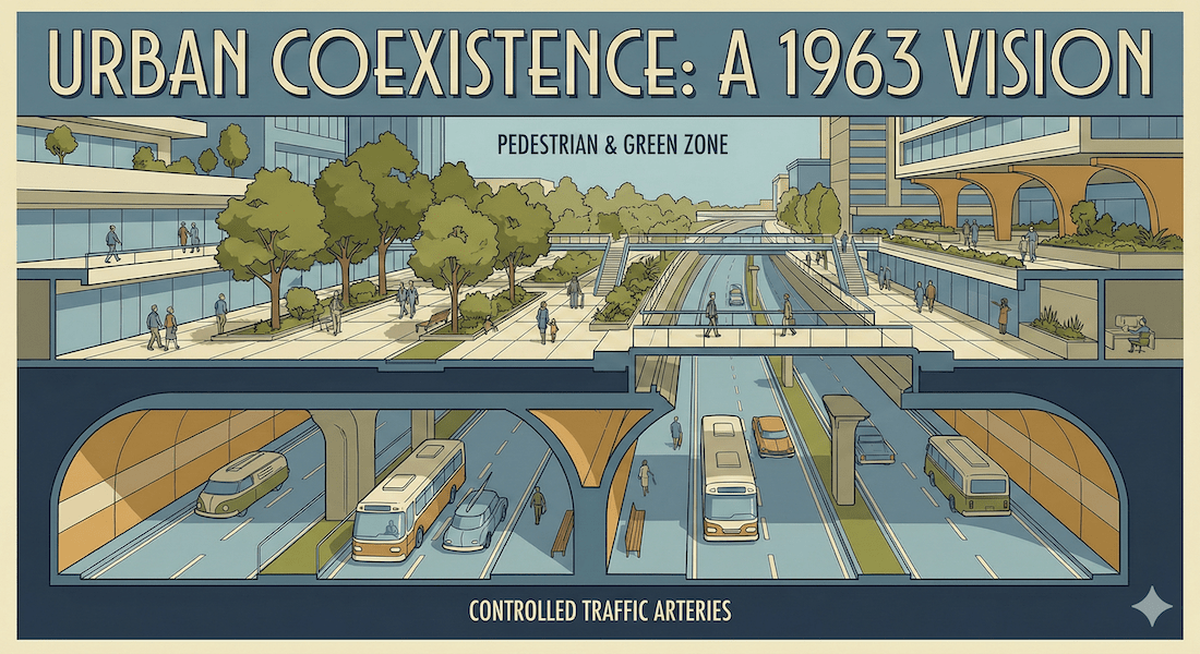
In drawing up this historic blueprint, Bachanan was far from just an armchair hypothesis. He is said to have conducted extensive research to learn lessons from urban planning methods overseas, where motorization was at the forefront at the time. The core concept he derived from this was"Environmental Capacity"This was an extremely revolutionary idea at the time, as it meant that each city block had an "absolute ceiling" for the number of vehicles that could be accommodated without damaging the "environment" such as pedestrian safety and the scenery.
To meet this limit, the report proposed that urban road networks be clearly divided into two tiers: "distributors" (arterial roads for movement) for large numbers of vehicles to travel at high speed, and "access roads" for accessing individual buildings and residences. The report also proposed the creation of blocks that completely exclude through traffic."Environmental Areas"This was strictly set as follows.
[Illustrated] Four practical case studies from the Vachanan Report
The report presented specific examples based on the size of the city and examined the effectiveness of the measures.
- Newbury (small town):He pointed out that before resorting to the easy external expansion of building a bypass, the internal circulation problem should first be fundamentally resolved.
- Leeds (large city):He proposed an innovative highway network that would include a hexagonal road pattern in the center (though he noted that this was unrealistic).
- Norwich (historic city):The conclusion was that historical buildings, which are the heritage of the English-speaking world, must be protected at all costs, even if it means restricting the use of automobiles.
- Fitzrovia, London (City Center):The project presents a redevelopment option for a three-dimensional megastructure called "traffic architecture," consisting of multi-level pedestrian decks and underground roadways.
The official report, published by HMSO in 1963, is widely cited as an expensive official document, costing 50 shillings, but its importance and impact led to a shortened paperback edition being published by Penguin Books in later years, and its ideas have since spread widely throughout society.
2. The genealogy of ideas and clear differences with similar systems
Buchanan's ideas were never fully realized in the UK as a policy outcome, due to the "astronomical costs" of completely redeveloping urban centers and building a network of urban expressways. However, his ideas had a major impact on Sweden, Italy, and Australia, and inspired the concept of the "Bonnnerf" (a road for both pedestrians and vehicles) in the Netherlands. He also indirectly influenced the Big Dig project, a project to convert elevated highways into underground highways in Boston, USA, several decades later.
The concepts of vehicle regulation and block design in urban development are often confused. Here, we will structure and compare the clear differences in the philosophy and approach of each method. Please scroll horizontally to view on a smartphone.
| System/concept name | Year proposed/Origin | Objectives and Approach | Clear differences from the Vachanan report |
|---|---|---|---|
| environmental region (Bacchanal Report) |
1963 uk |
The "environmental capacity" of urban blocks is set, and through traffic exceeding this capacity is completely and physically eliminated to protect pedestrian living space. | This is not simply a no-entry policy, but a macro-level concept that involves three-dimensional reorganization of the entire city, accompanied by TDM including electronic road pricing. |
| Zone 30 Zone 30 Plus |
From September 2011 From August 2021 Japan |
Residential roads will be treated as a whole, and through traffic will be restricted or eliminated through a maximum speed limit of 30 km/h and physical devices (such as road humps). | Rather than fundamentally creating multi-level elevated intersections, this is a "gradual and low-cost" approach that retrofits existing at-grade roads with police regulations and simple hard measures. |
| TOD (Transit-oriented development) |
1990s~ United States, etc. |
The aim is to concentrate high-density facilities around train stations and move away from dependence on automobiles. | While Vachanan assumes that automobile use will increase, TOD focuses on reducing automobile dependency itself. |
| Radburn System | 1929 US |
In new residential areas, the design completely separates the roadway (cul-de-sac) from the pedestrian-only greenway. | Radburn focuses on two-dimensional methods of "new development," while Bachanan includes the three-dimensional reconstruction of "existing densely populated historic cities." |
3. The pros and cons of implementing environmental regions
The creation of "environmental zones" that protect urban centers and historic districts from automobiles creates extremely powerful leverage in urban development, but also carries the risk of creating significant trade-offs (win-lose structures) among stakeholders. Here, we will compare and consider the advantages and disadvantages from the perspectives of the government, which formulates and implements policies, and the citizens and businesses, who use the infrastructure.
Ensuring absolute safety for pedestrians and enjoying the "civilization effect":
By completely eliminating through traffic from residential and commercial areas, we can reduce the risk of fatal accidents that frequently occur on narrow roads. This will enhance the "civilizing effect of walking" that Vachanan pointed out, and create places (human spaces) where citizens can breathe safely and enjoy shopping.
Sustainable mobility based on environmental capacity:
By combining demand control measures such as a permit system for entering designated zones, electronic road pricing, and total parking capacity restrictions and fee increases, it will be possible to break the cycle of endless road expansion and control congestion itself.
Restoring competitiveness of public transport networks and integrating communities:
By relatively limiting the inflow of private cars and improving public transportation, we can maintain and strengthen infrastructure. We can also reconnect communities that have been divided by road infrastructure and restore the value of roads as living spaces.
Astronomical financial costs and landscape destruction:
Realizing "traffic architecture" (multi-story megastructures) such as those proposed for London's Fitzrovia district would be extremely expensive to build, and would necessitate the destruction of historic squares and buildings, potentially irreparably damaging the amenity value inherent in the area.
Strong restrictions and increased burden on car users:
Road pricing and parking fee hikes will have a direct economic impact and a significant reduction in convenience for residents who rely on their own cars for commuting and daily life, as well as for suburban commercial businesses that rely on customers to visit by car.
Strain on the primary road network and chain reaction of traffic paralysis:
The large number of vehicles that are excluded from residential roads will be concentrated on "distributors (arterial roads)," which poses a structural risk of causing widespread bottlenecks if traffic signal control and capacity expansion cannot keep up.
Data reveals the unresolved "raging bull" issue in modern Japan
The threat of mixed pedestrian and vehicle use that was discussed in the UK has not been resolved at all in modern Japan. In fact, the problem is becoming more serious in today's aging society.
An examination of the National Police Agency's statistical data for 2023 reveals a significant fact: while the number of traffic accidents across Japan is on a downward trend, the risk of fatal and injury accidents on narrow roads (so-called residential roads) remains extremely high.
[Graphical representation] Percentage of pedestrian and cyclist fatalities by roadway width
*Data analysis based on National Police Agency statistics for 2023
5.5m or more
(25.9%)
Residential roads less than 5.5m wide
(46.9%)
According to National Police Agency data, the rate of pedestrian and cyclist fatalities and injuries is 46.91 TP3T on residential roads (less than 5.5m wide) and 25.91 TP3T on roads 5.5m or wider, clearly showing a higher rate on residential roads. How can we protect school routes and residential spaces from through traffic that uses them as shortcuts? The government is now under pressure to take immediate action.
4. Local Practices in Japan: Zone 30 Plus and Local Challenges
Progressive Line of Defense: Nationwide rollout of "Zone 30 Plus"
What should we do, given that the enormous cost of multi-level infrastructure redevelopment is impossible? The Japanese government has adapted Vachanan's ideas to suit modern conditions. This began with "Zone 30" (from September 2011), and has now been further developed into "Zone 30 Plus" (from August 2021).
This system treats residential roads as "zones" and restricts speed limits to 30km/h in zones, while also incorporating physical devices such as road humps and narrowing. By retrofitting existing surface road infrastructure with speed limits set by the police and low-cost physical measures by road administrators, the inflow of through traffic is curbed. In other words, it's a highly realistic approach to gradually and artificially creating "environmental zones" without incurring astronomical costs.
Toyako Town, Hokkaido: The dilemma of simultaneously satisfying tourism demand and daily transportation
Furthermore, regional tourist towns are being forced to take a different approach to "relationship design" than the congestion problems faced by large cities. Let's take a look at the example of Toyako Town in Hokkaido.
According to official tourism statistics (2024), Toyako Town is an international tourist destination with 645,881 overnight stays per year and total annual tourist spending of approximately 45.3 billion yen. However, as is the fate of regional cities, the number of users of local buses and other regional transportation services that have long served as transportation for residents has been declining, making maintaining these services an urgent issue.
Simply eliminating or reducing bus routes would make it impossible for elderly people who have surrendered their driver's licenses to continue living. On the other hand, continuing to operate large, conventional route buses empty would significantly strain local government finances. Furthermore, as a tourist destination, transportation design is required that can simultaneously satisfy the conflicting dual needs of "transport for elderly people to go to the hospital or go shopping" and "mobility for tourists traveling over a wide area" within limited resources.
One optimal solution to these issues is to build an ecosystem (circulatory structure) that reinvests existing tourism revenue sources (such as hot spring taxes) into maintaining local transportation and creating new on-demand transportation systems (such as MaaS). Rather than relying on the construction of massive physical infrastructure, we can optimize the capital already in the region using a software approach and create an environment where residents and tourists can enjoy a win-win. This could be said to be a sustainable answer to the modern-day "vacanic challenges" facing regional cities.
Conclusion: The evolution of mobility and the redefinition of community infrastructure
The 1963 Vachanan Report posed a fundamental question to us: how can we protect the "china shops" of cities from the "raging bull" of motorization?
The greatest legacy of the report is not the blueprint for a massively expensive multi-level road network, but"Roads should not simply be spaces for cars to pass through, but places for people to live in civilized ways."This is a firm philosophy.
As we look ahead to future urban development, we must not be distracted solely by "vehicle-side technological advances" such as autonomous driving and the shift to electric vehicles. We must face up to the fact that the structure of a city itself has an absolute upper limit known as "environmental capacity," and consider how we can ensure the safety of our communities with limited resources.
The spread of "Zone 30 Plus," which physically protects Japan's residential roads, and efforts to reorganize local transportation in tourist destinations vividly demonstrate the possibility of achieving "coexistence between automobiles and humans" by combining local resources and wisdom, without relying on astronomical infrastructure investments.
In conclusion, we must reexamine whether the spaces in our neighborhoods are simply consumed as "lines" through which people pass, or whether they are designed as "surfaces" that protect and nurture our lives. Creating a circular structure that is a win-win for both people and the environment is the single shortest route to building a safe and vibrant community foundation for the next generation.
Related Links
- Ministry of Land, Infrastructure, Transport and Tourism: Town development and urban planning
- National Police Agency: Promotion of Zone 30 Plus
- Toyako Town: Statistics for Toyako Town
Inquiries and requests
We help solve local issues.
Please feel free to contact us even if it is a small matter.


