〜How has the green belt, which originated from the British garden city concept, changed in Japan and is it affecting our lives?〜
*This article is based on publicly available information as of February 2026.
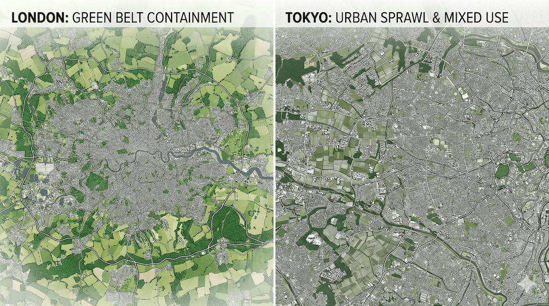
Did you know that when you look down on the world's major cities from high altitudes, you can see clear differences in their "contours"?
In some cities, the grey urban areas and the green forests and farmlands are clearly separated as if drawn by a compass, while in others, concrete buildings and rice paddies blend together in a mosaic, seemingly stretching out without boundaries.
The true nature of this decisive difference in the landscape is the most symbolic and powerful policy tool in urban planning:"Green Belt"is.
This concept, which originated in the UK over a century ago with the romantic ideal of a "marriage between urban and rural areas," has spread throughout the world and functioned as a "green growth management system" to curb the uncontrolled expansion of cities (sprawl).
However, the actual implementation and results of this system vary greatly depending on the country and region. Why are London's suburbs so green, while Japan's suburbs are dominated by a "gray" landscape? And what role should this "invisible boundary" play in today's world, where the population has shifted from a phase of growth to a phase of decline?
In this article, we will delve into the history and current status of green belts from the perspectives of land prices, infrastructure costs, and the "design of relationships."
1. What is a Green Belt? Definition and 5 Functions
It's not a "park" but a "growth management system."
First, we need to clear up a misunderstanding: "Green Belt" does not simply refer to "large parks" or "green spaces" in cities.
In technical terms,"A system of growth management that designates land on the periphery of cities and, in principle, does not permit inappropriate development in order to curb urban sprawl."refers to.
They are often called "belts" because they are designated as rings around cities, but their true nature lies not in their shape, but in the fact that they are a highly political and economic intervention measure known as "urban growth management."
Five Roles in Modern Urban Planning
In the context of modern urban planning, particularly the UK's National Planning Policy Framework (NPPF), green belts are seen to have five main roles:
-
① Curbing urban sprawl
By preventing cities from expanding endlessly into the suburbs like an amoeba and concentrating functions in the center, we will create efficient "compact cities." -
② Preventing city mergers
This prevents neighboring cities from expanding and connecting to form huge megalopolises, preserving the unique identities and independence of each community. -
3) Protecting the countryside and food base
It prevents the natural environment and agricultural land around cities from being encroached upon by urban land uses. -
④ Preservation of historical characteristics
In ancient cities and historic towns, we will preserve the environment that forms the background to these areas and maintain their character as historic cities. -
⑤ Promoting urban regeneration
By restricting careless development in the suburbs (greenfield development), development pressure will be redirected towards the city interior, and the redevelopment of unused land (brownfields) such as former factory sites will be encouraged.
2. Historical Changes: British "Ideals" and Japanese "Reality"
Origins: Howard's Garden City and the London Model
Let's turn back the clock to the end of the 19th century. After the Industrial Revolution, London had become a hotbed of overcrowding, unsanitary conditions, and poverty due to rapid industrialization. To save people from the smog-filled city, social reformer Ebenezer Howard proposed the following in his book, Garden Cities of Tomorrow:
"The city and the country must marry. From this joyous union will come new hopes, new lives, new civilizations."
The "Green Belt Policy" became firmly established in the postwar British urban planning system through this garden city idea, debates on London's regional planning in the first half of the 20th century, and legislation such as the Green Belt Act 1938. As a result, areas were established around London where development was generally prohibited, and "urban containment" was promoted as a national policy.
▲ Around London. You can see that green spaces have been clearly preserved outside the central city area.
Japan's turning point: From air defense green spaces to "line drawing"
However, its introduction in Japan has undergone unique changes. In the 1930s, this concept was referred to as the "Tokyo Green Space Plan," but the background to its introduction at the time was not only to the improvement of urban amenities, but also to the strong need for national defense, namely to secure "air-raid open space to prevent the spread of fires in the event of air raids."
Furthermore, after the war, as Japan entered the period of rapid economic growth, the influx of population into Tokyo exploded. Facing a desperate need for housing and strong opposition from landowners to restrictions on development rights, the government found it difficult to maintain the British-style "complete green belt."
As a result, with the enactment of the New City Planning Act in 1968, JapanThe "Senbiki" system divides "urbanization areas (places where urbanization is prioritized)" and "urbanization control areas (places where urbanization should be restricted)."This was a shift to an approach that organized the order and location of development, similar to the zoning method in the United States, rather than a blanket ban on development.
3. A thorough comparison: London vs. Tokyo
Why have London and Tokyo ended up in such different situations despite both aiming to "suppress the spread"? We will compare the structural factors behind this.
| Comparison items | [UK] Metropolitan Green Belt | [Japan] Urbanization Control Areas (Demarcation Lines) |
|---|---|---|
| Regulatory enforcement |
Strong Containment In principle, inappropriate development is not permitted. Exceptions are limited to agriculture, forestry, outdoor sports facilities, etc., and development rights are severely restricted. |
Moderate Regulation There are many exceptions to the development permit system, such as "farmhouses," "detached houses," and "public facilities," and in many cases development is actually possible. |
| Landscape Features |
Sharp Edge There is a clear division between urban land use and green spaces. |
Ambiguous Gray A sprawling landscape where houses, rice fields, material storage areas, and parking lots intermingle in a mosaic pattern. |
| Side effects and challenges |
Concerns about rising housing prices It has been pointed out that constraints on land supply are one of the reasons for the rise in house prices in London and other areas, as well as long-distance commuting that crosses restricted areas. |
Urban sponges The fragmented development has led to a decline in infrastructure efficiency, making it difficult to "fold up cities" when the population declines. |
*You can view the table by scrolling horizontally.
Conceptual diagram: Strength of urban development regulations and their impact on land prices
*Image showing the strength of regulations and general trends in market prices
4. Japan's Challenges: A "Gray" Landscape and Hidden Costs
The cost of ambiguity and sprawl
Japan's urbanization control zones are supposed to protect farmland, but in reality, development has taken place due to various "exceptions." This has resulted in the landscape shown below.
A typical "adjustment zone" near Tokyo. Housing, farmland, and warehouses are mixed together.
This "gray" development has huge hidden costs."Infrastructure inefficiency"is.
For example, just to accommodate a single farmhouse standing alone, local governments must lay hundreds of meters of water pipes, run garbage trucks, and, in some areas, remove snow in the winter. In times of continuous population growth, this could be covered by increased tax revenues, but in a society with a declining population, this thinly spread urban structure is becoming the biggest factor putting pressure on local government finances.
The future of productive green spaces and urban farmland
Furthermore, "productive green spaces," the remaining farmland within cities, are also facing a turning point. With the deadline for dedesignation approaching in many areas in 2022, efforts are being made to preserve this through the designated productive green space system, but how to maintain urban farmland remains an issue.
What is important here is to shift our perspective on the remaining green spaces in cities: whether we view them as "reserve land to be converted into residential land one day" or as "infrastructure essential for urban life" with disaster prevention and environmental adjustment functions.
5. Proposal for the future: "Green Belt 2.0" in an era of population decline
As heavy rain disasters caused by climate change become more severe, concrete levees alone are reaching their limits in protecting cities.
Therefore, from the perspective of "watershed flood control," there is a movement to designate riverside control areas and farmland as "flood plains" where water is deliberately allowed to overflow."A buffer zone to protect lives"This can be seen as an attempt to redefine it.
In rural areas where population decline is progressing, the 20th century objective of "preventing urban expansion" is disappearing.
The challenge going forward is to make the area outside the residentially-invited zone a de facto green belt, and by not encouraging people to live there, reduce the costs of snow removal and infrastructure maintenance."A border for withdrawal"This is a strategic decision to maintain sustainable government services.
Regional Case: Transformation of "Values" in Toyako Town
In Toyako Town, Hokkaido, one of the target areas of this survey, it is suggested that green belt-like regulations could be used as a lever for "brand formation."
In this region, which is home to Shikotsu-Toya National Park, strict building regulations and landscape protection measures limit the freedom of short-term development, but also curb uncontrolled development and help preserve the "world-class landscape." This very landscape attracts wealthy inbound tourists and can be a source of maximizing the long-term regional economy (capital).
Here, a paradox arises in which the "restrictions" that come from regulations create overwhelming "value."
Conclusion: Landscape is the "contract" of society
Having completed our journey through the debate over green belts, there is one truth we must discover: the urban landscapes that unfold before our eyes are not the product of chance, but something like a "contract" that shows what a society has chosen and what it has discarded.
Londoners traded extremely high housing costs for clear green spaces and access to nature, while Japanese people have prioritized freedom of land use and economic rationality in exchange for a certain degree of landscape chaos.
However, with the two enormous waves of climate change and population decline sweeping in, past contracts are being forced to be reconsidered. We need to be more imaginative about "hidden costs" and rethink green spaces as "infrastructure for survival" rather than simply vacant lots.
The next time you stand on the edge of a city, listen to what its boundaries have to say. They may paint a blueprint for our future.
Related Links
- Ministry of Land, Infrastructure, Transport and Tourism: Overview of the City Planning System
- UK Government (GOV.UK): Green Belt policy
- Ministry of Land, Infrastructure, Transport and Tourism: Green Infrastructure Portal Site
Inquiries and requests
We help solve local issues.
Please feel free to contact us even if it is a small matter.


