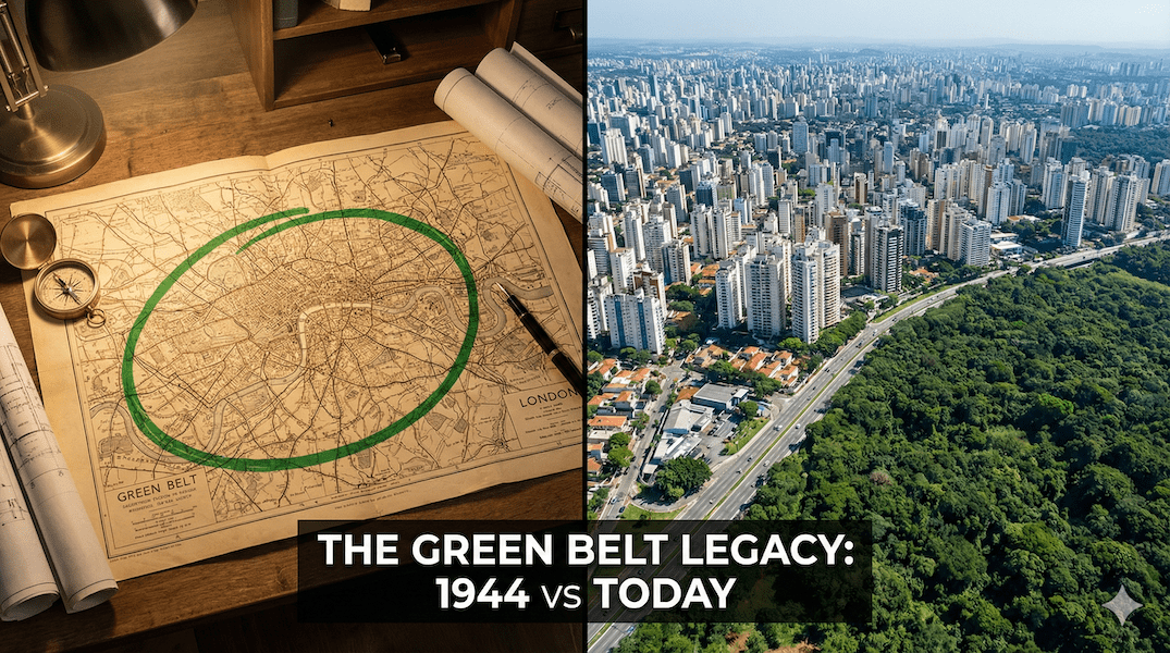
〜In 1944, what saved London from war damage was the decision to create a "Green Belt" to physically contain urban expansion.〜
*This article is based on official data as of February 2026.
A city needs a will. If it had no will, it would simply expand according to its own desires and eventually suffocate under its own weight.
Let's turn the clock back to 1944. In the midst of World War II, London has suffered extensive damage from air raids. However, amid the rubble, a grand and cold-hearted plan is quietly underway.
It was created by urban planner Patrick Abercrombie."Greater London Plan 1944"is.
This plan was not simply a blueprint for reconstruction. It was a massive, state-sponsored social experiment that physically blocked the city's uncontrolled expansion (sprawl) with a "green belt" and dispersed the overflowing population into planned new cities.
And now, more than 80 years after its creation, the "lines" Abercrombie drew have come to define London's landscape, while also presenting a new challenge: stagnant housing supply. Meanwhile, what can Tokyo, which continued to expand during its period of rapid economic growth, and regional cities in Hokkaido, which coexist in harmony with nature, learn from this historic plan?
In this article, we will unravel the full picture of the Abercrombie Plan and delve deeper into the paradoxical relationship between "regulation" and "assets" in modern urban development.
1. The Abercrombie Plan: Containment by the "Four Rings"
Destruction creates a reset button for utopia
First, we need to understand the background to the creation of the Abercrombie Scheme. Since the Industrial Revolution, London had continued to expand as the world's largest city, but it was suffering from poor living conditions and traffic congestion.
The destruction caused by war was tragic, but for urban planners, it was also a moment when the existing complex rights relationships could be reset and physical space created for radical "reconstruction."
Iron Discipline: The "Four Rings" Structure
Abercrombie's solution was to manage the city through a "four rings" structure of concentric circles, with London at its centre.
| Ring Name | Role and Purpose | Specific measures |
|---|---|---|
| 1. Inner City Ring (Inner Urban Ring) |
Eliminating overcrowding | In order to reduce population density, residents are deliberately forced to move out and industries are dispersed. |
| 2. Suburban Ring (Suburban Ring) |
Maintaining and stabilizing the status quo | The "edge" of an existing urban area does not allow any further expansion. |
| 3. Green Belt (Green Belt Ring) |
"Physical Blockage" of Urban Expansion | A development control zone approximately 10km wide, a buffer zone to stop urban expansion. |
| 4. External Country Ring (Outer Country Ring) |
Creating a platform | A self-sustaining "new town" was built in the countryside, cut off from London. |
*You can view the table by scrolling left and right.
The most important thing here was the third ring, namely"Green Belt"The Town and Country Planning Act of 1947 effectively nationalized land development rights (making it a permit system), giving this idea strong legal backing.
The map below shows the current state of the Green Belt surrounding London. You can see that the green belt completely surrounds the city center (gray).
Central London and surrounding areas. The green belt outside the city center acts as a physical barrier to urban expansion.
2. [Comparative Verification] London's "Lockdown" vs. Tokyo's "Expansion"
The uniqueness of Abercrombie's ideas becomes clear when compared to Japan's postwar reconstruction, particularly the Capital Region Development Plan.
In fact, Tokyo also had a green belt plan in the 1950s, but the outcome was different.
Differences in urban structure and development policy
| Comparison items | London (Abercrombie style) | Tokyo (high economic growth period) |
|---|---|---|
| Green Belt (Development regulations) |
[Strong and permanent] It functions as a "wall to stop urban expansion" and currently occupies approximately 12.51 TP3T of England's land area (as of 2025). |
[Concept only, policy change] Initially, it was conceived as a "suburban area," but due to the growing demand for housing, this was not fully realized, and in fact the urban area expanded outward. |
| New Town (Population support) |
Self-contained city The principle was to have workplaces and homes close to each other. Factories and offices were relocated as a set, and the aim was to create an "independent country" where people could live without having to commute to London. (e.g. Stevenage, Harlow) |
[Dormitory] It is a "city where people go to sleep" where people commute to the city center. The daytime population is low, making it easy for people to commute long distances. (Example: Tama New Town) |
*You can view the table by scrolling left and right.
[Data] Expansion of commuting areas and differences in density
Comparison of urban structure models
*You can scroll the image horizontally to see the details.
*London has a clear, empty area called the Green Belt (GB), whereas Tokyo has a continuous, expansive urban area.
3. Light and Shadow: Abercrombie's Legacy and "Modern Anguish"
Eighty years after the plan was first put into place, London's Green Belt is still maintained to this day, but this overly powerful "ideal" has had some side effects in modern times.
- Preventing converging:
The boundaries between urban and rural areas were made clearer, and the identity of surrounding municipalities was preserved. - Access to nature:
The "lungs of the city" for the citizens were guaranteed a place for weekend recreation.
- Rising housing prices:
Due in part to limited land supply, the median house price in London is expected to reach approximately 11 times the median annual gross salary of full-time employees (ONS data for 2024), indicating a decline in affordability. - Leaping frog phenomenon:
Development pressures spilled over into areas outside the green belt, creating traffic congestion due to long-distance commutes.
The "Grey Belt" became a political hotbed
In recent years, the nature of this regulation has been debated in the UK. In particular, even within the green belt, land with low environmental value (such as former gas station sites) is being restricted."Grey Belt"There have also been policy proposals to classify these areas as such and allow development there.
This is not a complete rejection of Abercrombie's philosophy, but rather an attempt to update urban planning to suit the times, from "absolute sanctuaries" to "strategic green space management."
4. Implications for Toyako and Hokkaido: Abercrombie's Reversal in an Era of Population Decline
Now, here comes the highlight of this article. How can Japan, especially Hokkaido and Toyako Town, in the 2020s, where the population is declining, apply the wisdom of London in 1944, which fought against overcrowding?
"Natural Green Belt" based on the National Parks Act and hazard maps
Toyako Town is located within Shikotsu-Toya National Park,natural park lawFurthermore, Mount Usu is an active volcano that has erupted repeatedly at intervals of about 20 to 30 years, so land use zoning based on hazard maps is essential.
At first glance, these may seem like "hindrances to development," but from an Abercrombie perspective, they are its strongest assets. This is because Toyako Town can make the following "promises" to immigrants and investors:
[Toyako Town's Promise (Value Proposition)]
"This beautiful lake and forest landscape will be protected for the future because the Natural Parks Act and disaster prevention zoning protect it from uncontrolled development."
The view of Tokyo will disappear if a building is built next door, but the view within the national park is a legally protected asset. In addition, the geological heritage recognized as a UNESCO Global Geopark also enhances the brand value of the region.
The area around Lake Toya. The natural environment itself functions as the "strongest restriction line" in urban planning.
"Resort telework settlement area" where work and home are close to each other
Modern digital infrastructure has rendered physical distance ineffective. The lifestyle of "work globally, live within the national park" is a modern version of the Garden City. With a view to wide-area collaboration, the area has the potential to become a "premium commuter town" that offers a high-quality living environment while sharing functions with surrounding areas such as the Niseko area.
Bottom line: drawing boundaries means choosing your future.
The biggest lesson we can learn from Abercrombie's London Plan is"The courage to envision a city as a physical boundary"is.
Post-war London rejected the limitless expansion of the future by drawing the Green Belt, and tried to maintain the "ideal state" of the city. As a result, the surrounding countryside has been preserved to this day.
What will be required of Japan's regional cities in the future is not just "what to build (development)" but also "what to create (development).""Where not to build (conservation)"It is our intention to clearly define this. We will reject hasty development and manage the beauty of the region over a period of 100 years. From a global perspective, these inconveniences and restrictions will become our most luxurious and valuable assets, and will act as a magnet that draws people to the area.
Related Links
- Ministry of Land, Infrastructure, Transport and Tourism: Progress of the Capital Region Development
- Ministry of the Environment: Shikotsu-Toya National Park and Park Plan
Inquiries and requests
We help solve local issues.
Please feel free to contact us even if it is a small matter.


